Big Laurel Falls Earthcache EarthCache
Big Laurel Falls Earthcache
-
Difficulty:
-

-
Terrain:
-

Size:  (other)
Please note Use of geocaching.com services is subject to the terms and conditions
in our disclaimer.
Big Laurel Falls
Earthcache
Virgin Falls Pocket
Wilderness

Welcome to one of the most fascinating
places that I have ever visited in my Geocaching experience to
date. This area has proved itself to be the most head-scratching
area, and most unique location for a bunch of caches to find. It is
places like this that makes the whole reason for Geocaching for
me..to discover new places that you never knew existed, but yet
they are located in your backyard. Who would have even known that
this was here except for this addicting hobby that does things like
this to you.
This is the Virgin Falls Pocket Wilderness. The trailhead is on
Scott's Gulf Road which is at the extreme eastern end of White
County. The trail descends to meet Fork River Gorge providing
access to Big Branch Falls, Big Laurel Falls and Virgin Falls.
Expect to take seven to eight hours for the round trip if you go
all the way in. The trail is moderate to difficult and good hiking
boots are strongly recommended. Despite the challenges, it is an
absolute pleasure to walk and soak in the scenery.
The focus of this earthcache lies on one of the unique landforms
that you will come across when hiking the Virgin Falls Pocket
Wilderness trail. It is known as Big Laurel Falls, and it is about
halfway to the end of the trail which is the amazing Virgin Falls
(See GCZEZA).
As you hike down the trail, you find yourself stepping across, and
later wading across, a progression of larger and larger mountain
streams. Ultimately, these streams all join to form Big Laurel
Creek, which the lower trail follows for some distance. After a
little over 2 miles, the rushing water suddenly tumbles over a
40-foot high drop-off to create Big Laurel Falls, the second
waterfall you encounter along the Virgin Falls Pocket Wilderness
trail.
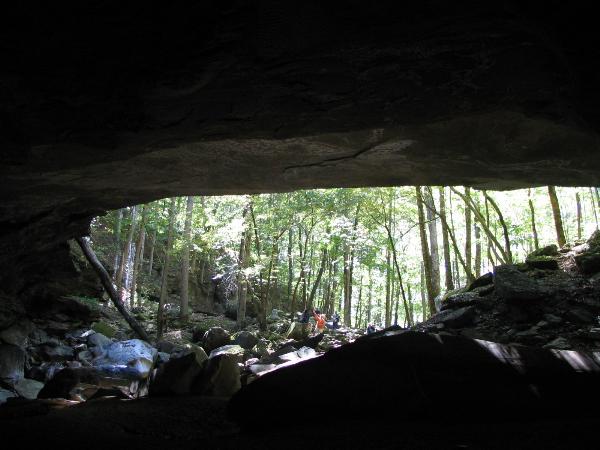
Big Laurel Falls is actually a huge sandstone rock house or rock
shelter. The water from the falls sinks at a couple of different
places near the rear wall of the rock shelter. This same water
eventually turns up in Sheep Cave and later Virgin Falls Pit. This
presents an enticing puzzle for cavers and speleologists: Where
does the water go? So far, no one has been able to find out, but
one thing is known for sure: Water in the Virgin Falls Pocket
Wilderness, and in Scott's Gulf as a whole, spends as much time
underground, as it does aboveground.
Logging Requirments
1) Take a picture of you and your GPS standing
at the falls! You can be on top of the falls, behind the falls, in
front of the falls, to the side of the falls, or however you want
around the falls....I really don't care. What I do want though, is
for you to be clearly identified with your GPS in your hand at the
falls.
2) With your GPS, mark the two sets of coordinates for the far ends
of the mouth of the falls...once you have the coordinates, measure
the distance between the two marks and you will have the width of
the opening. Send those measurments to me via email!
3) Go inside the room and observe the ground....Email me what you
see. I am mainly looking for the formation that runs along
the back wall.
4) Tell me if you don't think this is a great place to pitch a
tent and spend the night 
Additional Hints
(No hints available.)