
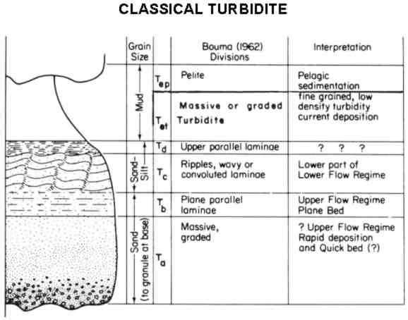
 Turbidites form in the deep ocean near the continental
shelf. Classic turbidite sequences are made up of fining
upward beds of sediment. This means that the grains at the
bottom of the sequence are larger than the grains at the top
of the sequence. In a complete sequence the bottom sediments
are pebble sized conglomerates, followed by coarse then
fine-grained cross-bedded sandstone, then shale, and finally
silt. This series is called the Bouma cycle.
Turbidites form in the deep ocean near the continental
shelf. Classic turbidite sequences are made up of fining
upward beds of sediment. This means that the grains at the
bottom of the sequence are larger than the grains at the top
of the sequence. In a complete sequence the bottom sediments
are pebble sized conglomerates, followed by coarse then
fine-grained cross-bedded sandstone, then shale, and finally
silt. This series is called the Bouma cycle.
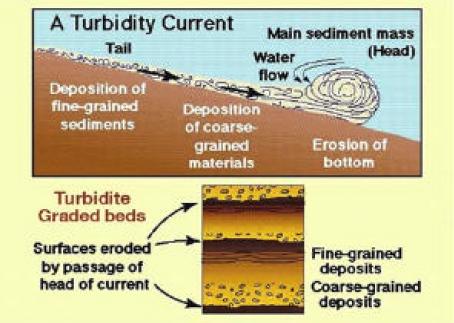
A turbidite is formed by a density flow. In this type of flow,
the fine grained sediments suspended in the water increases the
density of the water. The denser water is then able to suspend
larger particles than it normally would be able to. For example a
rock will sink quickly in pure water, but sink much more slowly in
thick mud.
 Typically, the entire sequence is not seen
because each successive flow will erode off some of the top of
the last sequence, or if the deposit is at the end of the
flow, only the finer layers will be seen.
Typically, the entire sequence is not seen
because each successive flow will erode off some of the top of
the last sequence, or if the deposit is at the end of the
flow, only the finer layers will be seen.
Usually turbidites form off of a convergent plate margin (where
two plates are colliding). A convergent margin provides the
mountains that are good sources of sediment, sufficiently steep
off-shore slopes and periodic earthquakes to trigger the undersea
landslides.
 That is the case in the sequence of rocks at this
location. Only the fine-grained sand, shale and silt layers
are seen in these cliffs, suggesting that they formed at the
far end of the turbidite. Hundreds and possibly thousands of
density flows occurred to create the tall cliffs of repeating
sand, shale, and silt layers you see in these cliffs.
That is the case in the sequence of rocks at this
location. Only the fine-grained sand, shale and silt layers
are seen in these cliffs, suggesting that they formed at the
far end of the turbidite. Hundreds and possibly thousands of
density flows occurred to create the tall cliffs of repeating
sand, shale, and silt layers you see in these cliffs.
Turbidites continue to form just off the coast. A pair of deep
marine canyons extend out into the Santa Monica Bay from Mugu
Lagoon and Port Hueneme. These canyons transport loads of sediment
down into the Santa Monica Basin.
Logging requirements:
Send me a note with :
- The text "GCZJNF Point Mugu Turbidites" on the first line
- The number of people in your group.
- In a 3-foot section, how many density flows occurred? Include
how you determined the start and end of each flow.
- Based on the thickness of each of the layers was each event the
same size? Include how you came to that conclusion.
The above information was compiled from the
following sources:
- Wikipedia,
http://en.wikipedia.org/wiki/Turbidite
- SUZANNE REYNOLDS (1987) A recent turbidity
current event, Hueneme Fan, California: reconstruction of flow
properties Sedimentology 34 (1), 129–137.
doi:10.1111/j.1365-3091.1987.tb00565.x
- Field trip guide to the Marin Headlands (Golden
Gate National Recreation Area) and the Point Reyes National
Seashore; Geology of the National Parks, San Francisco State
University, April 20, 2002