🇹🇼
歡迎光臨到【蘭嶼【寶】島】 (風化)
為了回答那些在最下面那裏所寫的問題,只需要靠著在這個地質寶的寶頁上的資料,而不用特地去搜尋任何的其他的事情。我已經很努力把所有的資料寫得清清楚楚,寫得像白話文一樣,因此您只要認真看一看寶頁上的事情就可以了。所以記得去找這個寶之前要先認真看寶頁的資料哦。先跟您說一聲謝謝,謝謝您去找這個地質寶,希望您找得愉快跟順利哦!加油!
在這個【地質寶】您會學到【風化】,學到了之後您可以到場然後去回答一些問題來【找到】這個地質寶。(問題在這個寶頁最下面)。準備好了嗎?來啊,一起學習【風化】吧!
|
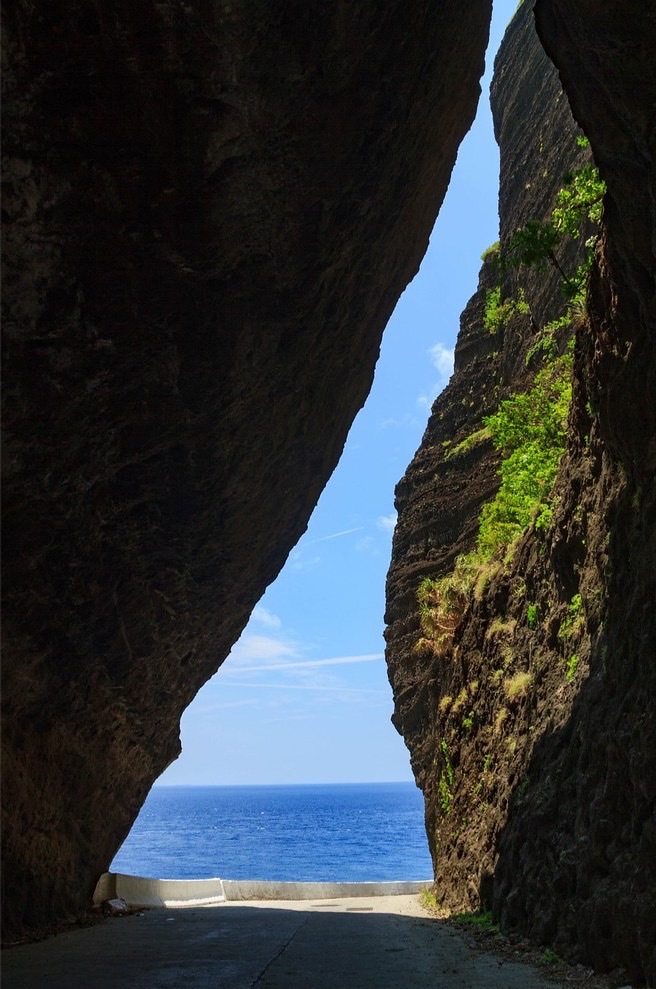
風真的強到可以把這麼大這麼硬的巨石打碎嗎?
當您到這個地方時您會發現這裡的風不是普通的強哦,而是強到差點會被吹倒或者吹走。跟這個巨石比起來我們像是一根羽毛而已所以我們被風移走的是有道理的,但是這塊巨石呢?怎麼可能也會被風【移走】呢?
【風化】或者【風蝕】是一種【塑造法】。什麼叫做【塑造法】呢?就是大自然用其力量去塑造地球上的岩石,像這塊巨石。大自然這麼塑造呢?用【風】的力量!沒錯!就是【風】!風把沙子啊,小小石頭啊,等物吹來吹去。當這些小小東西被吹到這個巨石時,他們都會摩擦到巨石。這樣的過程不斷地重複好幾百萬年,慢慢塑造了石頭上的【條紋】。這些條紋叫做【風成波痕】。您在這巨石上可以看到好多好多這樣的【條紋】。酷吧?
下面這個圖可以進一步地去瞭解這些【條紋】是如何被塑造的:
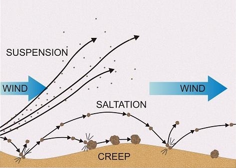
⇒ 懸移(Suspension) — 一粒一粒被吹得很高很高然後可以被吹到好遠很遠的地方去了
⇒ 躍移 (Saltation)— 一粒一粒被吹得很平而且不會被吹到很遠去了
⇒ 潛移(Creep) — 一粒一粒被吹但只會在地上滾來滾去
所以在這個巨石上可以看到很多很多因為懸移,躍移,還有潛移而塑造的【條紋】。這些條紋可能會看起來蠻直的或者也許看起來蠻【畢卡索性的】,就是歪歪的嘛,呵呵。巨石上可以看得到:
⇒ 小小的波痕 — 這種條紋是因為躍移作用而塑造直直的或者首位曲曲的一條一條【波痕】。通常這種條紋才幾公分之長而已但還是在這能看得到一些些。
⇒ 大大的波痕 — 這種跟【小小的波痕】的塑造法一樣,只是這種會長很多,可能達到二十五公分之長。在這個巨石上可以看到很多很多的這種波痕
⇒ 快速波痕 — 這種波痕因為一粒一粒移得蠻遠而且移得時候移蠻快的所以塑造了很多很長又很平的條紋在這個巨石上。
這塊石頭並不只是一種無趣的石頭,它是一種證據來證明大自然的力量相當的強壯!不然這個石頭怎麼會被塑造成這樣呢?
|
如何【找到】這個【地質寶】呢?
為了【找到】這個【地質寶】,請您前往【寶頁中所寫的座標】然後再回答下列幾個問題。
一。 根據您對【風化】的瞭解還有根據您在這裡的觀察,您能看得到什麼樣的【異物】被吹來吹去?這些【異物】是從哪個方向來呢?
二。根據您對【懸移】,【躍移】,還有【潛移】的瞭解還有根據您在【第一題】所觀察到的,哪一種風化過程是最明顯呢?您覺得為什麼那種風化過程最明顯呢?
三。 根據您對【波痕】的瞭解,哪一種波痕是最看得見的?還有這些條紋在巨石上的哪個位置呢?這些條紋的位置告訴您風化是怎麼影響這個巨石?
四。 根據您從上面那些題目所得到的知識,您覺得這塊巨石為什麼只有一些部分被風化了?為什麼其他的地方看起來比較沒有被風化或者沒有很明顯的條紋呢?您覺得這些【尚未風化】的部分以後會被風化嗎?為什麼會這麼認為或不認為呢?
五。如果想的話,可以PO上去一張您在這裡的個人照,或PO上去一張跟【地理尋寶】有關的照片。
到場後並回答所有的問題,可以直接【Log Found!】。如果我覺得答案需要稍微進一步地去回答的話我會跟您聯繫。
小小的溫馨叮嚀哦,不要把任何的答案寫在您的【Log】裡面哦,乖。
祝您有著美好的時光造訪此地質寶。
🇺🇸
Welcome to Lanyu — An Island of Geological Wonder! (WIND EROSION)
All information presented in this Earth Cache is all the information you need to complete the on-site tasks, which you can find at the bottom of this web page. There is no need to do any other additional research as I have made every effort to present all the necessary things in a clear and simple way to ensure quick and easy understanding. So just stick to the information here on this Earth Cache page and make sure to read through everything before venturing out to find this Earth Cache. Thanks in advance for visiting and I hope you enjoy your time on Lanyu! Cheers!
In this earth cache, you will learn about wind erosion — and how this magical geological process helped shape this unique rock face right along the northwest tip of this island. And upon learning everything there is to know about wind erosion, you will be ready to put on your Geological Science Caps on location here. And after you answer the task questions and complete all your Wind Erosion Studies and Observations (which can all be found at the bottom of this page), you can log a “Found It!” for this Earth Cache. I hope you enjoy! Are you ready? Let's begin . .
|
How Can Something Like the Wind Be So Powerful to Weather Such a Massive Monolith Here?
As you will experience at this location the wind is unbelievably strong and powerful. Almost so strong at times that it seems to sweep you off your feet, right? But we are a mere feather in weight compared to the colossal rock here so it makes sense why we might be moved by the wind but this huge rock face? How can it be "moved" by the wind, or rather more accurately stayed, weathered by this wind?
Geologically speaking, wind erosion, which is also known as "Aeolian process", is when small "dust-like" particles like dirt and sand are moved by the wind and cause weathering or erosion upon the land. But how does something as small and fine like dust and sand cause a reshaping of the land? Well, as these particles of dirt and sand move in the wind, they brush up against things in their way. And after brushing up against things in their way over again for many, many years, those particles of dirt and sand leave their mark on rocks and other landforms. And this is exactly what happened to this huge rock face here at the Posted Coordinates — the wind left its "mark" — ripple marks that is along sections of this rock face.
Here is a diagram outlining the different Aeolian processes that took place here that left these ripple marks upon the rock :
⇒ Suspension — this is when particples are catapulted high in the air and usually travel great distances
⇒ Saltation — this is when particples are blown horizontally and usually travel just a short distance
⇒ Creep — this is when the particles just roll on the ground
So here upon this rock face you can see streaks or these "ripple marks" caused by suspension, saltation, and creep. They vary in size and symmetry to the "perfect" symmetrical lines to the more "Picasso" style of asymmetrical creativity. You can see:
⇒ Impact Ripples — these are located near where saltation occured and take on a straight or slightly wavy design. They are usually just a few centimeters in length and you can see patches of these kinds here
⇒ Megaripples — formed the same way as impact ripples but these are much longer in length — upwards of 25 meters long and there are definitely quite a few examples of these here too.
⇒ Aerodynamic Ripples — these form by long saltation paths taken by grains in suspension and grains on the ground surface and this high velocity of grain movement result in long, flat designs, which is also clearly visible here as well.
So this rock here is more than just a monolith of Mother Nature — it is a testament to the power of the wind and how it has reshaped and rescuplted this unique location over the past eons.
|
Logging Requirements:
Lanyu is an island of Geological Wonder with so many unique landforms and hidden geological treasures, with one in particular — The Rock That Harnessed the Wind (as I like to call it) — which is a place where you can get up close and personal with a "forgotten" sculptor — The Wind.
In order to log a Found It! for this Earth Cache, please go to the Posted Coordinates to complete the following tasks:
1. Based on what you what you have learned about how learned about Aeolian processes, and based on your observations here, in which direction(s) is the "debris" being blown in to brush up against and sculpt this rock face? And what kind of "debris" can you observe here?
2. Based on what you have learned about suspension, saltation, and creep, and based on your observations in Task 1, which process is most prevalent here at this rock? Why do you think this is so?
3. Based on what you have learned about ripple marks, which one is the most prevalent here and where on the rock face is it located? What does this tell you about the overall Aeolian process and how it has affected this location?
4. Based on all the knowledge gained from the tasks and observations above, why do you feel that only particular sections of the rock are affected by Aeolian process? Do you feel that other "unaffected" areas will also be reshaped by the wind? Why or why not? How did you come to your conclusions?
5. Optional — Post a photo of yourself or a "Geocaching" item identifying yourself here at "The Rock that Harnessed the Wind."
You may log a Found It! on this cache after you have completed the tasks and emailed me the answers. If there are any issues with your answers, I will contact you. And as a friendly reminder, please do not post any of the answers in your logs. Thank you for visiting this Earth Cache. I hope you enjoy your time here at Rock that Harnessed the Wind.