
 Góra Swietej Anny – Opolski
Wulkan
Góra Swietej Anny – Opolski
Wulkan
 St Anna Moutain -
Volcano
St Anna Moutain -
Volcano
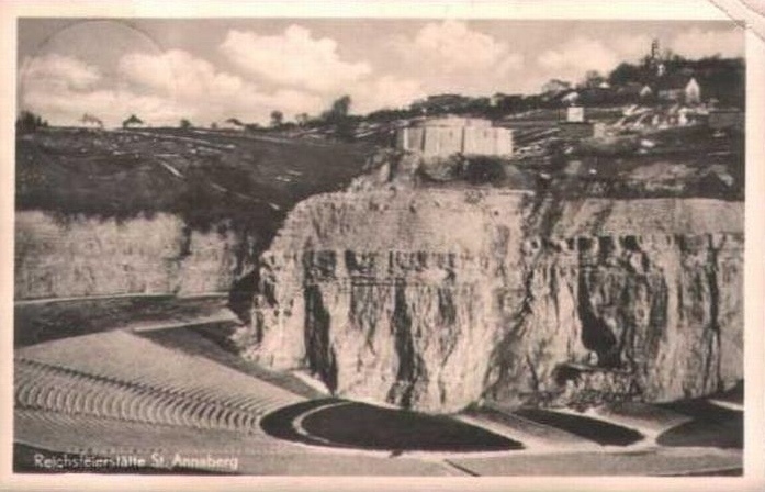
Góra Sw Anny – amfiteatr kiedys
 |
POLSKI
OPIS
|
O miejscu:
„Bazalt na Górze sw. Anny pojawil sie 27 mln lat temu po
powstaniu glebokiego pekniecia siegajacego 50 km w glab ziemi.
Peknieciem tym z otchlani wydostala sie lawa o temperaturze okolo
1100 st. C, formujac na powierzchni stozek wulkaniczny podobny do
Wezuwiusza, choc zapewne znacznie nizszy. Po schlodzeniu zmienila
sie w nefelinit. W pewnym momencie oprózniona z magmy komora
magmowa zawalila sie nagle, powodujac zapadniecie wiekszej czesci
stozka. Takie rozlegle zapadlisko w centrum wulkanu nazywa sie
kaldera.
Trwajaca miliony lat erozja calkowicie zniszczyla stozek, a nawet
gruba warstwe wapieni, na których spoczywala góra. Nastepnie erozja
usunela miekkie skaly osadowe otaczajace komin wulkaniczny laczacy
wulkan z lezaca w glebi komora magmowa. W ten sposób twarde,
bardziej odporne na erozje bazalty komina zaczely wystawac ponad
sasiadujace wapienie, formujac niewielki szczyt zwany naukowo
twardzielcem. Wznosi sie on dzis ponad 20 m nad wsia, a na jego
wierzcholku ulokowano kosciól i klasztor.
Rezerwat Geologiczny ( waypoint):
Przez dlugie lata kamieniolom ten byl trudno dostepny i
niebezpieczny, gdyz silnie zarosniete strome zbocza grozily
kontuzja przy upadku. Jednak w 1996 pracownicy Parku Krajobrazowego
Góra sw. Anny usuneli cztery tony smieci, wykonali sciezki
dydaktyczne i odslonili spod ziemi i roslin najciekawsze punkty
geologiczne, wyposazajac je w tablice z objasnieniami, fotografiami
i rysunkami. Wykonali tez schody na dno najglebszego z tutejszych
wyrobisk i wybrukowali tam bazaltem 45 m drogi .
Wejscie na sciezke dydaktyczna zaczyna sie tuz za
pólnocno-zachodnim rogiem posesji zajazdu Pod Góra Chelmska. Na
dnie najglebszej odkrywki wyeksponowano kilka punktów z pieknie
widocznym ciosem bazaltowym, czyli pionowymi piecio- lub
szesciobocznymi slupami grubosci do 20 cm, na które popekala skala
w czasie szybkiego stygniecia. Tutejsze bazalty sa troche bardziej
zasadowe od klasycznych bazaltów i dlatego w naukowej nomenklaturze
nazywane sa nefelinitami.
Na trasie zejsciowej eksponowany jest kilkumetrowy blok piaskowca
kredowego (cenoman, 100 mln lat) zatopiony w lawie, na kontakcie
widac czerwona warstwe, powstala w efekcie reakcji pomiedzy lawa a
skala. Wychodzac z dna lomu, mija sie odsloniecia piasków i margli
kredowych, bedacych fragmentem znacznie wiekszego bloku. W marglach
(turon, 95-90 mln lat) wystepuja liczne skamienialosci (jezowce,
amonity, malze), jednak nie wolno ich tu zbierac, mozna natomiast
obejrzec w muzeum w siedzibie parku krajobrazowego na Górze sw.
Anny.
Wzdluz górnej krawedzi tej odkrywki dostrzega sie lessy, skale
utworzona z pylu nawianego tutaj z ladolodu zajmujacego pólnocna
Polske 20 tys. lat temu.
Po przejsciu sciezka do wschodniej czesci rezerwatu zwiedzamy punkt
ekspozycyjny przy wlocie do najwiekszej jaskini Góry sw. Anny,
wysokosci 0,5 m i dlugosci 5 m, zalozonej w wapieniu triasowym
(tzw. warstwy karchowickie sprzed 240 mln lat), w którym odkryto
liczne morskie skamienialosci, m.in. gabki, ramienionogi i
liliowce. Stad sciezka prowadzi w góre ku lejowi krasowemu, który
jest o tyle ciekawy, ze powstal w póznej kredzie, podczas gdy
wiekszosc polskich lejów krasowych jest znacznie mlodsza i pochodzi
z trzeciorzedu.
Wracajac sciezka w dól, dojdziemy do jednej z dwóch najwiekszych w
Polsce soczew jaspisu (2x1x0,5 m). Powstala ona wskutek kontaktu
goracych zmineralizowanych roztworów powulkanicznych z wapieniem
bogatym w krzemionke, pochodzaca m.in. ze skamienialych gabek
zawartych w wapieniu. Jaspis ten nie nadaje sie do wyrobów
jubilerskich, gdyz jest silnie porowaty.
Tuz nad soczewa wystepuje piekna strefa metamorfizmu w strefie
granicznej miedzy triasowym wapieniem a wciskajaca sie w niego
rozpalona do 1100 st. C lawa. Widoczne sa tam pokazne przeobrazenia
obu skal, powstale pod wplywem gwaltownego stygniecia bazaltu i
nagrzewania sie wapienia. W efekcie bazalt stal sie niezwykle
kruchy, odbarwiony i porowaty, wapien zrobil sie czarny, zas na
samym kontakcie z wapienia pozostala tylko biala warstwa
kalcytu.
Ostatnim punktem w rezerwacie jest wyniosly wzgórek, górujacy nad
okolica, zbudowany z brekcji piroklastycznej. W czasie erupcji
wulkan wyrzucal w powietrze ostrokrawedziste kawalki starszego, juz
zastygnietego bazaltu oraz strzepy plynnej lawy, która lecac,
stygla, przybierajac czasem formy skreconych bomb wulkanicznych lub
popiolu (tufu). Takie wyrzucone eksplozja i opadle fragmenty lawowe
nazywamy wlasnie piroklastykami.
Dlaczego jednak te dosc miekkie skaly tworza wierzcholek? Otóz, gdy
wydobywano wapienie i bazalty, to wielkie, majace kilkadziesiat
metrów dlugosci bloki piroklastyków byly zupelnie nieprzydatne
gospodarczo, wiec zostawiano je nienaruszone, wybierajac wokól nich
uzyteczne kopaliny. Tak powstal stozek tufowy, objety ochrona
prawna jako pomnik geologiczny juz w latach 20. XX
wieku”
Za Gazeta Opole „Nasz opolski wulkan” Dr Robert
Niedzwiedzki
Amfiteatr
Jeszcze troche historii:
„Gdy Góra Sw. Anny znajdowala sie jeszcze w rekach III
Rzeszy, dokladniej rzecz ujmujac - w latach trzydziestych ubieglego
wieku, hitlerowcy zapragneli stworzyc ogromny amfiteatr, gdzie
moglyby odbywac sie wielkie wiece polityczne, a takze wybudowac
mauzoleum dla uczczenia poleglych Niemców. Tak tez i uczynili, w
miejscu dawnego kamieniolomu w roku 1938 ukonczono budowe tegoz
amfiteatru. Wedlug róznych zródel moze on pomiescic od 30 do 100
tysiecy widzów, to czyni go jednym z najwiekszych w Europie. Warto
tu zaznaczyc, iz w ówczesnym okresie nalezal on do grona
najwiekszych amfiteatrów na swiecie i wyróznial sie znakomita
akustyka.
W mauzoleum - które z wygladu przypominalo wieze czolgu -
znajdowaly sie prochy niemieckich zolnierzy bioracych udzial w III
Powstaniu Slaskim. Jesienia 1945 roku, po przegranej przez
hitlerowców drugiej wojnie swiatowej, mauzoleum zostalo wyburzone.
W jego miejscu Polacy wybudowali Pomnik Czynu Powstanczego, który
zostal zaprojektowany przez Xawerego Dunikowskiego. Uroczystego
odsloniecia pomnika dokonano dnia 19 czerwca 1955
roku.”
Wiecej na :
http://www.goraswanny.yoyo.pl/historia_gory_sw_anny.htm

Góra Sw Anny amfiteatr obecnie
Zdjecia pochodza z serwisu:
http://www.goraswanny.yoyo.pl/historia_gory_sw_anny.htm
Skrytka:
Aby uzyskac zaliczenie Earth-Cache nalezy wybrac sie na miejsce
(Amfiteatr oraz Rezerwat) i przeslac do nas na adres
ms.geoteam@gmail.com odpowiedzi na nastepujace pytania:
1. Budowniczy amfiteatru wykorzystali naturalna niecke krateru
wulkanu - oszacuj wysokosc/glebokosc amfiteatru lub zrób jego
zdjecie.- Amfiteatr
2. W którym roku zostal utworzony rezerwat geologiczny Góra Sw.
Anny? – Rezerwat Geologiczny
3. Kamieniolom ma ksztalt owalny. Jaki jest przebieg jego osi
dluzszej? – Rezerwat Geologiczny
4. W których czesciach kamieniolomu wystepuje nefelinit (bazalt)?
– Rezerwat Geologiczny
 |
ENGLISH
DESCRIPTION
|
About this spot:
St Anna Moutain – Volcano
St. Anne’s Mountain, or in the language of local Germans -
Sankt Annaberg, is a special place on the map of Opole
Silesia.
Basalt at Mount St. Anna appeared 27 million years ago, after the
formation of deep cracks reaching 50 km deep into the earth.
Rupture of the depths of the lava got out at a temperature of about
1100 ° C, forming a volcanic cone on the surface similar to that of
Vesuvius, though probably much lower. After cooling has changed in
nefelinit. At some point, drained of magma magma chamber collapsed
suddenly, causing the collapse of a larger part of the cone. Such
an extensive depression in the center of a volcano called
caldera.
The continuing erosion of millions of years, completely destroyed
the cone, and even a thick layer of limestone, on which rested a
mountain. Then erosion removed the soft sedimentary rocks
surrounding the volcano neck attached as lying in the depths of the
magma chamber. In this way, hard, more resistant to erosion basalt
chimney began to protrude above the adjoining limestone, forming a
small peak called scientific twardzielcem. Today it stands over 20
meters above the village, and on its vertex was located church and
monastery.
Geological Reserve(waypoint):
For many years it was difficult QUARRY available and dangerous,
because the very steep slopes are covered with an injury threatened
to fall. But in 1996, employees of National Park Mountain St. Anna
remove four tons of garbage, have completed didactic and unveiled a
path out of the ground and plants the most notable geological,
equipping them with the information boards, photographs and
drawings. Also have done the stairs to the bottom of the deepest
workings of local there and paved the way 45 m basalt.
The entrance to the trail starts just behind the north-west corner
of the property “Under the mountain Chelm” inn (zajazd
Pod Góra Chelmska). At the bottom of the deepest pit exhibited a
few points with the beautifully visible blow basalt, a five-or
vertical columns szesciobocznymi to 20 cm thick, which had cracked
the scale during rapid cooling. The local basalts are slightly more
alkaline basalts from the classics and that is why the scientific
nomenclature are called nefelinitami.
The route is exposed zejsciowej block of sandstone, several meters
Cretaceous (Cenomanian, 100 million years old) lost in the lava,
the contact can see the red layer, was formed as a result of the
reaction between the lava and rock. Exiting from the bottom lomu,
August unveiling marks the tar sands and marls, which are part of a
much bigger block. In marglach (Turonian, from 1995 to 1990 million
years) occur numerous fossils (urchins, ammonites, bivalves), but
do not collect them here, but you can look at the museum at the
headquarters of a landscaped park on the Mount St. Ann.
Along the top edge of the pit in August sees the loess, a rock
formed from the dust of the ice sheet here nawianego zajmujacego
northern Poland 20 thousand. years ago.
After passing the path to the eastern part of the reserve visit the
exposition at the intake point for the largest cave of Mount St.
Anne, the height of 0.5 m length of 5 m, which was founded in
Triassic limestone (so-called layer karchowickie before 240 million
years), which found numerous marine fossils, including sponges,
brachiopods and crinoids. Stad path leads upwards towards lejowi
krasowemu, which is interesting, as created in the late Cretaceous,
while the majority of Polish karst funnels are much younger and is
from the Tertiary.
Coming back down the path, we come to one of the two largest in
Poland, jasper lenses (2x1x0, 5 m). It was created by contact of
hot mineralized solutions powulkanicznych with limestone rich in
silica, such as datingthe fossil sponges in limestone . Jasper is
not suitable for jewelry, because it is highly porous.
Just above the lens of beauty zone metamorphism occurs in the
border zone between Triassic limestone and press themselves in a
burning him up to 1100 deg C lava. Obviously there are some
substantial transforming both scales was influenced by sudden
cooling of basalt and limestone in August heat. As a result of
basalt became extremely brittle, discolored, and porous, limestone
had become black, while the same contact with the only remaining
white limestone layer of calcite.
The last point in the reserve is exalted hill, towering over the
neighborhood, built of pyroclastic breccia. During the eruption,
the volcano threw up in the air ostrokrawedziste older pieces,
already zastygnietego basalt and shreds of molten lava, which is
flying, stygla, sometimes assuming the form of twisted volcanic
bombs and ash (tuff). Such an explosion and ejected lava fragments
called fallen already piroklastykami.
But why do they form a fairly soft rock vertex? Now, when mined
limestone and basalt, it is huge, with dozens of meters in length
blocks were completely useless piroklastyków economically, so leave
them intact, selecting useful minerals around them. Thus was
created tufowy cone, protected by law as a geological monument
already in the 20s Twentieth century.
For newspaper Opole “Opole volcano” Dr. Robert
Niedzwiedzki
Amphitheater - second place
Just a little history:
When Mount St. Anne was still in the hands of the Third Reich and,
more specifically - in the thirties of last century, the Nazis
wanted to create a huge amphitheater, which could be dealt a big
political rallies, as well as build a mausoleum to commemorate the
fallen Germans. And so is done, the site of a former quarry in 1938
was completed the same amphitheater. According to various sources,
it can accommodate from 30 to 100 thousand spectators, it makes it
one of the largest in Europe. It is worth noting that in the
contemporary period, it belonged to the group of the largest
amphitheaters in the world and was distinguished by excellent
acoustics.
In the mausoleum - which reminded of the appearance of a tank
towers - there were the remains of German soldiers taking part in
the Third Silesian Uprising. In autumn 1945, after defeat by the
Nazis, the Second World War, the mausoleum has been demolished. In
its place they built a monument Polish Silesian Uprisings, which
was designed by Xawery Dunikowski. The ceremonial unveiling of the
monument was made on 19 June 1955.
Photos from the site:
http://www.goraswanny.yoyo.pl/historia_gory_sw_anny.htm
The cache:
To get credit Earth-Cache must go to the place (Amphitheater and
Geological Reserve )and send us an email ms.geoteam @ gmail.com
answers to the following questions:
1. Builder of the amphitheater used the natural volcanic crater
basin - estimate the height / depth of the amphitheater or take his
picture.(optional) - Amphitheater
2. In which year was set up geological reserve of St. Anne's
Mountain? - Geological Reserve(waypoint)
3. Crushed stone is an oval shape. What is the course of its axis
longer? - Geological Reserve(waypoint)
4. In which parts of the quarry nefelinit occurs (basalt)?
(information board)? - Geological Reserve(waypoint)
Please, log "Found it" after having received ours
confirmation.
Happy Caching!!.