We thought we would end this year on a high, and you cannot get much higher than Mount Everest.
So on New Year’s Eve 2019 from 11am till midday an event will be held to climb to the summit of Mount Everest. We will start the ascent from the South Summit, specialist equipment will be required for the final 60” of solid ice, making a total of 8,848" the height of Everest
At each stage there will be Sherpas available to assist with the assent up to the snow and ice, and on to the summit. This is where an ice-pick will be required to reach the very top. You may bring your own or one can be provided for your use; Please bring climbing ropes, warm clothing, emergency rations, flags to plant and anything else you consider necessary.
Base Camp (RHS of Cadover Top Carpark)
The expedition will start at the base camp, where climbers will have to acclimatise and equip themselves before, they fly to the South Summit and on to the final stages of the accent.

South Summit (8748”)
Final health and safety checks, time to say goodbyes, you may not come back.
Stage 1 – Cornice Traverse, a horizontal face of snow and rock
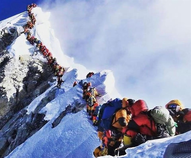
Follow the well-worn path towards the summit, beware you might have to join a queue. Don’t be tempted to leave the well-trodden path. The mountain is not very hospitable to those who don’t wait their turn.
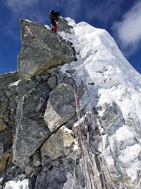
Stage 2 – Hillary Step
Here is a formidable challenge, only a few brave men (and women) have made it past here. Only one person at a time is allowed on the step. This near vertical rock face with a height of 12” is the last real challenge. Fixed ropes are placed to assist the climbers.
Stage 3 – Final Ascent
Here you will have to climb the last 60”, for the final ascent, time to place your feet on the summit and wave your flag. At the top will be the logbook to sign, remember your pen. Ice picks will be provided for those that have got this far without one. Optional, we have our photographer in from Woolwell, they are well used to taking awful photos
Log your Will Attends
Time now to log your "Will Attend"s and get into practice for the grand expedition. If we have a total white out we may have to relocate to the more accessible ground of K2. Notification of any changes will be via this cache page.
Mount Everest
(Nepali: Sagarmatha सगरमाथा; Tibetan: Chomolungma ཇོ་མོ་གླང་མ; Chinese: Zhumulangma 珠穆朗玛) is Earth's highest mountain above sea level, located in the Mahalangur Himal sub-range of the Himalayas. The international border between Nepal (Province No. 1) and China (Tibet Autonomous Region) runs across its summit point.
The current official elevation of 8,848 m (29,029 ft), recognised by China and Nepal, was established by a 1955 Indian survey and subsequently confirmed by a Chinese survey in 1975.
In 1865, Everest was given its official English name by the Royal Geographical Society, as recommended by Andrew Waugh, the British Surveyor General of India, who chose the name of his predecessor in the post, Sir George Everest, despite Everest's objections.
Mount Everest attracts many climbers, some of them highly experienced mountaineers. There are two main climbing routes, one approaching the summit from the southeast in Nepal (known as the "standard route") and the other from the north in Tibet. While not posing substantial technical climbing challenges on the standard route, Everest presents dangers such as altitude sickness, weather, and wind, as well as significant hazards from avalanches and the Khumbu Icefall. As of 2019, over 300 people have died on Everest, many of whose bodies remain on the mountain.
The first recorded efforts to reach Everest's summit were made by British mountaineers. As Nepal did not allow foreigners into the country at the time, the British made several attempts on the north ridge route from the Tibetan side. After the first reconnaissance expedition by the British in 1921 reached 7,000 m (22,970 ft) on the North Col, the 1922 expedition pushed the north ridge route up to 8,320 m (27,300 ft), marking the first time a human had climbed above 8,000 m (26,247 ft). Seven porters were killed in an avalanche on the descent from the North Col. The 1924 expedition resulted in one of the greatest mysteries on Everest to this day: George Mallory and Andrew Irvine made a final summit attempt on 8 June but never returned, sparking debate as to whether or not they were the first to reach the top. They had been spotted high on the mountain that day but disappeared in the clouds, never to be seen again, until Mallory's body was found in 1999 at 8,155 m (26,755 ft) on the north face. Tenzing Norgay and Edmund Hillary made the first official ascent of Everest in 1953, using the southeast ridge route. Norgay had reached 8,595 m (28,199 ft) the previous year as a member of the 1952 Swiss expedition. The Chinese mountaineering team of Wang Fuzhou, Gonpo, and Qu Yinhua made the first reported ascent of the peak from the north ridge on 25 May 1960.
From Wikipedia October 2019