Sharp Springs Sinkhole EarthCache
-
Difficulty:
-

-
Terrain:
-

Size:  (other)
Please note Use of geocaching.com services is subject to the terms and conditions
in our disclaimer.
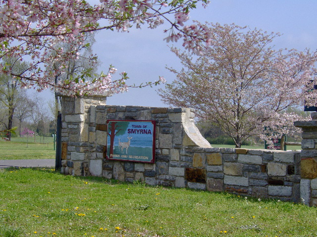
You’re about to embark on a refresher course in basic geology, make a few discoveries, and enjoy the great outdoors at Sharp Springs Park in Smyrna, TN. You will not have to venture into the woods to claim this Earthcache. GZ is right off the parking lot. There are grills, picnic tables, shelters and walking paths here for your enjoyment, and a few physical caches in the park to hunt as well.
If it seems familiar to you, this is the "new and improved" V2.0 of an Earthcache that was here until March 2010.
For those of you who think this area looks like something you may have seen on TV, it was pointed out by Delta.Force that the area is a visual reminder of the lagoon scenes in the shows "Flipper" and "Gilligan's Island". As I agree while recalling those classic shows, I came up with another one - - "Gentle Ben". You younger folks may not be familiar with those shows, but you "seasoned" folks will know exactly what we mean. Thanks Sheila for the stroll down memory lane.
Wheelchair and stroller accessible
Please note park hours:
March thru October, 7:00 a. m. - 9:00 p. m
November thru February, dawn 'til dusk.
Park hours are subject to closure due to inclement weather conditions.
This Earthcache is not what you may first think. Although it appears to be a pond, it is not.
A pond is a body of standing water, either natural or artificial, that is usually smaller than a lake. They may arise naturally in floodplains as part of a river system, or they may be somewhat isolated depressions (examples include vernal pools and prairie potholes). Usually they contain shallow water with fishes, marsh and aquatic plants and animals.
What you observe here is in fact a sinkhole, but not your typical sinkhole. It is one of three discussed on this page.
To claim this Earthcache, please email to me via my profile link, the answers the following questions:
(1) Briefly define what type of sinkhole you observe here.
(2) How large do you guess the sinkhole to be? Do you see evidence of it getting larger, smaller?
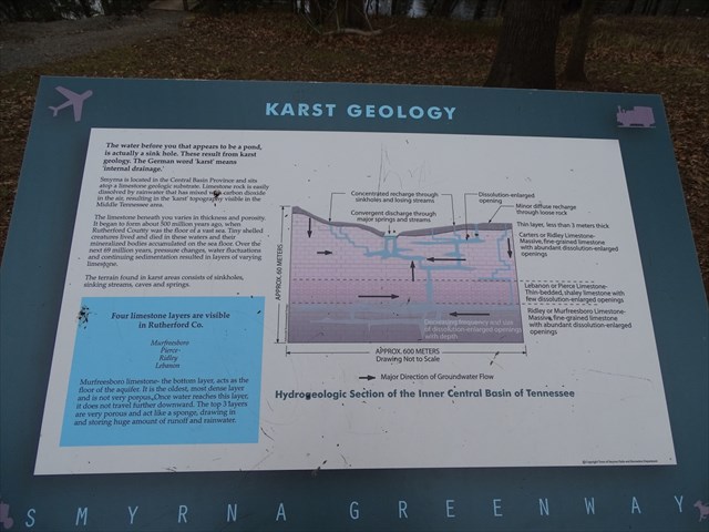
(3) What four limestone layers are in Rutherford County?
(4) How long ago did the limestone formation in Rutherford County begin?
(5) How long did the process last?
A picture or pictures of you and/or your group at or near the Earthcache welcome, but not required.
Do not post answers in your log or it will be deleted.
A sinkhole, such as this one, also known as a cenote, sink, sink-hole, shakehole, swallet, swallow hole, or doline (the different terms for sinkholes are often used interchangeably), is a depression or hole in the ground caused by some form of collapse of the surface layer. Some are caused by karst processes—for example, the chemical dissolution of carbonate rocks or suffosion processes.
Sinkholes may vary in size from three to 2,000 ft both in diameter and depth, and vary in form from soil-lined bowls to bedrock-edged chasms. Sinkholes may be formed gradually or suddenly, and are found worldwide. In July 2015, scientists reported that active pits, related to sinkhole collapses and possibly associated with outbursts, have been found on the comet 67P/Churyumov-Gerasimenko by the Rosetta space probe.
Sinkholes are found in most all states, but more especially Florida, Texas, Alabama, Missouri, Kentucky, Tennessee, and Pennsylvania. The sinkhole you find here is estimated to have begun about 500 million years ago when this area of Tennessee was on the floor of a vast ocean. The bodies of tiny sea urchins accumulated and mineralized on that sea floor. Pressure changes, water fluctuations and sedimentation over the next 69 million years resulted in the limestone layers which we know today as “karst”. You can read more about this at the information station near the sinkhole.
Natural Processes
Sinkholes may capture surface drainage from running or standing water, but may also form in high and dry places in specific locations.
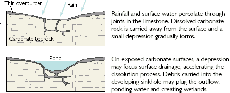
The formation of sinkholes involves natural processes of erosion or gradual removal of slightly soluble bedrock (such as limestone) by percolating water, the collapse of a cave roof, or a lowering of the water table. Sinkholes often form through the process of suffosion. For example, groundwater may dissolve the carbonate cement holding the sandstone particles together and then carry away the lax particles, gradually forming a void.
Occasionally a sinkhole may exhibit a visible opening into a cave below. In the case of exceptionally large sinkholes, such as the Minyé sinkhole in Papua New Guinea or Cedar Sink at Mammoth Cave National Park in Kentucky, an underground stream or river may be visible across its bottom flowing from one side to the other.
Sinkholes are common where the rock below the land surface is limestone or other carbonate rock, salt beds, or in other rocks, such as gypsum, that can be dissolved naturally by circulating ground water. Sinkholes also occur in sandstone and quartzite terrains.
As the rock dissolves, spaces and caverns develop underground. These sinkholes can be dramatic, because the surface land usually stays intact until there is not enough support. Then, a sudden collapse of the land surface can occur.
More and more sinkholes are being reported in neighborhoods throughout the country where entire sections of rural roadway, city streets and even homes are being swallowed up.
Dissolution Sinkholes
Dissolution of the limestone or dolomite is most intensive where the water first contacts the rock surface. Aggressive dissolution also occurs where flow is focused in preexisting openings in the rock, such as along joints, fractures, and bedding planes, and in the zone of water-table fluctuation where groundwater is in contact with the atmosphere.
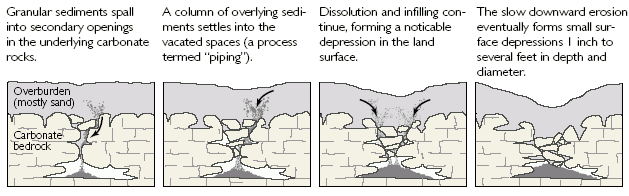
Cover-Subsidence Sinkholes
Cover-subsidence sinkholes tend to develop gradually where the covering sediments are permeable and contain sand. In areas where cover material is thicker or sediments contain more clay, cover-subsidence sinkholes are relatively uncommon, are smaller, and may go undetected for long periods.
Cover-Collapse Sinkholes
Cover-collapse sinkholes may develop abruptly (over a period of hours) and cause catastrophic damages. They occur where the covering sediments contain a significant amount of clay. Over time, surface drainage, erosion, and deposition contribute to the further formation of the sinkhole into a wider, shallower bowl-shaped depression.

I hope you enjoy this discovery as much as I did developing it.
Informational sources: http://water.usgs.gov/, www.wikipedia.com.
Additional Hints
(No hints available.)