Die Buehrener Orgelpfeifen
Deutsche Version:
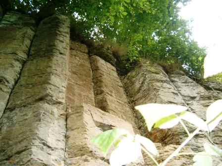
Buehren gehoert zum Naturraum des "Leine-Weser-Berglandes".
Die Basaltsaeulen aehneln optisch den "Pfeifen" einer Kirchenorgel,
daher der Spitzname "Buehrener Orgelpfeifen".
Die Buehrener Basaltwand ist ca.10m hoch,
und soll aufgrund ihrer prägenden Bedeutung
fuer das Landschaftsbild als Naturdenkmal ausgewiesen werden.
Der Basalt in dieser Region befindet sich in einem Bett aus
tertiaeren Sanden, Muschelkalk und Bundsandstein.
Diese "Basalt-Saeulen" entstanden, durch duennfluessiges,
kieselsaeurearmes Magma, dass an der Erdoberflaeche
austrat und langsam erkaltete.
Durch das verzoegerte Zusammenziehen
bildeten sich sechseckige Saeulen.
Die Ursache dafuer entstand vor ca. 12-14 Mio.Jahren (Vulkanismus):
Durch langsame Fliessbewegung des Erdmantels,
dehnten sich die Platten der Erdkruste,
dadurch kam es hier zu einer Spaltenbildung,
wobei Magma aus einer Tiefe von ca.60km
an die Erdoberflaeche gelangte.
Naehere Informationen findet Ihr vor Ort.
Um diesen Earthcache zu loggen,
muesst Ihr folgende Aufgaben erfuellen:
* Begebt Euch zu den angegebenen Koordinaten
und macht mit Euch und Eurem GPS`r ein "freiwilliges" Foto,
ungefaehr so, wie auf dem "Spoiler-Foto" zu sehen ist.
* Um wieviel Meter senkten sich die Gesteine im Leinetal?
* Was fuer ein Ausschnitt wird uns an der "Basalt-Wand" gezeigt?
Schickt mir bitte per E-Mail
ueber mein "Profil" die richtigen Antworten!
English version:
Buehren belongs to the nature area
of the "Leine-Weser mountain country".
The basalt columns visually resemble the "pipes" of a church organ,
therefore the pointed name: "Buehrener Orgelpfeifen".
The "Buehrener basalt wall" is about 10m high,
and is for the public representation in the landscape,
to regard as proven nature monument.
The basalt in this region lies in a bed from tertiary Sand,
shelly limestone and colored sandstone.
These basalt columns resulted from liquid acid-poor magma,
that appeared at the earth's surface and cooled off slowly.
By retarded pulling together, hexagonal columns were formed.
The cause for it,
developed approximately 12-14 million-years ago (volcanism):
By slow flow movement of the Earth's mantle,
the plates of the earth's crust was stretched.
It opened splits here, whereby magma from a depth of
approximately 60km to the earth's surface arrived.
Further information you can find near this place.
In order to log this Earthcache,
you must fulfill the following tasks:
* Go to the indicated coordinates
and make with you and your GPS´r a "voluntary" photo,
approximately in such a way,
as is to be seen on the "spoiler photo".
* Around how much meters did the rocks
in the "Leinetal" lower themselves?
* What for a cutout do we see at the "basalt wall"?
Sends me the correct answers by email (over my profil)!
 "Happy-Caching"
***** spoilt76 *****
 !No Risk, No Fun!