
Most of Calshot Spit is directly accessible on foot. Part of the beach to the southwest towards Eaglehurst is accessible. However a short distance beyond Luttrell's Tower there is a nature reserve with no public access. Unless permission is obtained, there is no direct access to the best cliff sections. They can be seen at a distance.
Calshot Spit is easily reached by driving southeast down the B3053 on the western side of Southampton Water past Fawley Oil Refinery and Fawley Power Station. There is some free parking at Hillhead (the landward end of the spit) and there is pay and display parking further to the northeast, at the beginning of the spit, about halfway down and at the Calshot Activites Centre at the end. There are toilets and a cafe and bar (open at times) within the activities center.
Most of Calshot Spit is directly accessible on foot. Part of the beach to the southwest towards Eaglehurst is accessible. However a short distance beyond Luttrell's Tower there is a nature reserve with no public access. Unless permission is obtained, there is no direct access to the best cliff sections. They can be seen at a distance.
The spit comprises a pebble structure and etween it and the main shore is a salt marshy area with a wealth of wildlife and birds. The long shingle spit that guards the entrance to Southampton water was formed when the sea broke through what is now the Needles channel. An event that occurred when sea levels rose after the Ice age. Tides deposited gravels from the now drowned river bed along the new coast forming spits at Calshot,Hurst,Stone point and Needs Ore.
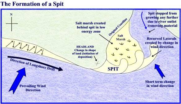
Spits are also created by deposition. A spit is an extended stretch of beach material that projects out to sea and is joined to the mainland at one end.
Spits are formed where the prevailing wind blows at an angle to the coastline, resulting in longshore drift.
To log this cache just email the answers and post a picture of your visit to your log if you like.
1. What do you notice on the seaward beach and why are these structures in place (The structures I am looking for are on the beach NOT the fort).
2. What is the length of the spit.
3. What is stopping the spit from growing further in length Please note this is an Earthcache, please submit your answers to me, logging 'found it' 'TFTC' or 'Thanks' log will be deleted.