Out for a Stroll in the Morrison
Objectives:
1) To observe, for yourself, evidence that dinosaurs once walked the earth;
2) To learn more about these creatures and how they left footprints that have lasted 150 million years!
3) To take photographs of these footprints (optional).
Supplies:
For good photographs of the footprints, take a whiskbroom to brush off the dust and debris, or you can fill the footprints with water to outline them better. Low-angle (dawn or dusk) lighting improves chances of good pictures. Making casts with plaster is forbidden.
Drinking water, sunscreen.
Directions:
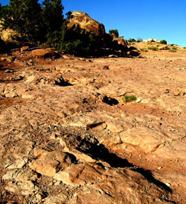
The site is located on BLM land and maintained by them. Proceed on Hwy 191 (north if you are coming from Moab, south if you are coming from Crescent Junction). The turnoff is to the east off Hwy. 191 at: N 38 49.493 W 109 46.886.
Note: The sign to the site is not visible from the highway. You’ll cross a cattle guard and railroad tracks where you'll see the first BLM sign. From there you will find good markers at all intersections. The road winds around for 2.1 miles with 0.5 miles on bumpy cobblestones. We made it in our low-clearance Honda Civic but we would recommend delaying your trip if the road is wet and muddy.
You can park at: N 38 49.796 W 109 45.792. Follow the trail for 500’ to the tracks which begin just below a BLM descriptive sign. The tracks are depressions in the sandstone roughly centered at: N 38 49.900 W 109 45.723
Educational Requirement:
To get credit for this EarthCache you must answer at least one Study Question.
Study Questions: [This can be a short sightseeing visit or an extensive study unit, as you wish.]
1.) Which species of dinosaurs left their footprints here? Mill Canyon
2.) How are those dinosaurs related to each other? Dinosaur Classification
3.) Imagine you are a dinosaur scientist. How would you decide how a dinosaur moved? … What he ate? … Whether he was peaceful or vicious? Do you think they sounded like this? If not, why not?
Bonus points for pointing out a feature near the trackway that indicates the origin of the Ridge’s name.
Have fun!
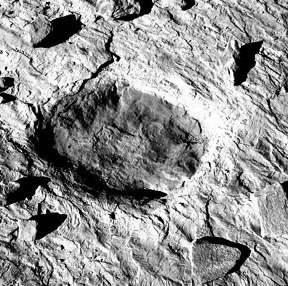
You'll get much better pictures if you GENTLY dust off the prints with a whiskbroom!
"The Bible" on Utah dinosaurs, Dinosaurs of Utah, was written by Frank DeCourten: DeCourten
Other resources:
Wikipedia Article
Family Visit
UC Berkeley on Dinosaurs
Ideas about dinosaur behavior