At the end of the Paleozoic Era, approximately
275 million years ago, about 50 million years before dinosaurs ever
walked the earth, a collision between the American, European and
African landmasses caused the earth’s crust to buckle and
fold. Along the eastern
edge of what is now North America, that fold is visible as the
Appalachian Mountains.
Pine Mountain is the last and westernmost of the great ridges of
the Appalachian Mountains. In fact, as you travel west from
the ridges forming Pine Mountain, which includes Black Mountain,
the highest point in the state, there are no higher natural
geological land features until you reach the Rocky Mountains.
The smaller mountains and ridges west of the
Appalachian Mountains, including Pine Mountain, were formed by what
geologists call thrust faults. Thrust faults occur when one land
mass actually slides over another, one pushing upwards and the
other going underneath, at an angle generally less than 45 degrees.
Pine Mountain was
formed when two large chunks (a southeastern portion and
northwestern portion) of rock collided. The southeastern portion of the
earth’s crust (the Virginia piece) slid atop a northwestern portion
(the Kentucky piece) forming the mountain we see
today.
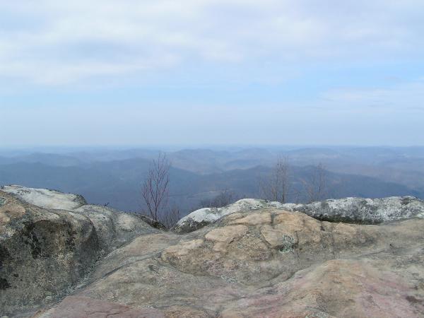
The listed coordinates will take you to the
highest crest of Pine Mountain called “High Rock,” which is located
in the Bad Branch Falls State Nature Preserve. The bald sandstone rocks
forming High Rock and on which you should be standing at the given
coordinates, form the “dip slope,” or the more gradual southeast
slope of Pine Mountain.
The northwest face is much steeper and is formed by the upturned
edge of the earths crust allowing you to see the layers of rock
strata, some of which are normally found 2,000 feet below
ground. When
looking at the highest peak at High Rock, located to the left if
you are facing the edge, you can see the rock layers pointing
upwards.
The rocky outcrop that you will stand on at
the listed coordinates affords spectacular views of the city of
Whitesburg as well as the ridges of Southeastern
Kentucky. The hike to
High Rock is a moderate to strenuous hike that is approximately 7.5
miles roundtrip if you start from the Bad Branch Falls Nature
Preserve or about 10 miles roundtrip if you hike in on the Pine
Mountain Trail from Highway 119. You can begin your hike in one of
two places. You can
start at the beginning of the Bad Branch Falls Trail which will
also lead you to a spectacular waterfall or you can start at the
Highlands parking area of the newly formed Pine Mountain Trail and
hike along the ridge tops of Pine Mountain to reach High Rock.
PLEASE
NOTE: High Rock is located in a state nature
preserve. Please stay
on the trail at all times and obey all posted rules for the park
regardless of whether you start at the Bad Branch Falls Trail or
the Pine Mountain Trail. This is a long and moderate to
strenuous hike and allow ample time to complete. The preserve is open from DAWN to
DUSK and a sign at the beginning of the Bad Branch Falls Trail
lists the latest recommended time to start your hike in order to
return before dark.
During the summer the latest recommended time to start your hike is
11:30 so plan ahead accordingly once the days become
shorter. Permission for
this Earthcache has been provided by Kyle Napier, the Southeastern
Regional Nature Preserve Manager of the Kentucky State Nature
Preserves Commission.
To log
this Earthcache… you must take a picture of yourself with the
highest peak of High Rock in the background. Additionally, you must email us
the answers to the following questions. DO NOT post the answers to these
questions in your log or it will be deleted!
1.
Pine Mountain was at least 1000 feet taller in the
past. Using
evidence or clues from where the coordinates take you, what
natural processes might explain why the mountain is now
smaller?
2.
What is the altitude at the posted coordinates?
3.
At what angle has the earth’s crust been pushed up here, and is
this consistent with a typical thrust fault? To answer this question you will
first have to collect some data while at High
Rock. Take a
waypoint at the lower edge of the rock, near the tree line
(within 100-200 feet of the edge), and use your GPS to note
the altitude.
Then take another waypoint at the top edge of High Rock,
again noting the altitude. Using geometry you can now
calculate the angle the earths crust was forced up
at. We’ll call
the distance in altitude A and the distance between the two
waypoints B and assume this makes a right
triangle. To
calculate the angle that the rock has raised you will take
the inverse sine of A divided B as shown in the formula
below
Angle = sin-1(A/B)
If you are having problems with calculations
let us know and we will be glad to assist you. Additionally, if you are not able
to take a picture of yourself or have any other problems or
questions please email us before you log this cache
online. Please email
the answers to the above questions before logging online, however
you do not have to wait for a reply before logging your
find. Good luck and
happy hiking!
Additional Information
High Rock is located in the 2,639 acre Bad
Branch Falls Nature Preserve (BBFNP) which protects one of the
largest concentrations of rare and uncommon species known in the
state. Additionally,
the only known nesting pair of common ravens (Corvus corax) in the
state can be found in the preserve. Directions to
BBFNP: From
the junction of KY 15 and U.S. 119, located S.E. of
Whitesburg, KY in Letcher County, follow U.S. 119 south 8.0
miles. Turn left
at the junction with KY 932 and travel east for 2.0 miles to
a gravel parking area on the left side of KY 932. Parking: N37°04.041,
W082°46.329.
Pine Mountain Trail is a planned 120 mile
trail reaching from Breaks Interstate Park to Cumberland Gap
National Historical Park, along the Pine Mountain
ridge. Pine
Mountain represents one of the last great contiguous
stretches of unfragmented forest in Kentucky. While other
parts of the region have been developed, strip-mined or
heavily logged, Pine Mountain remains relatively untouched.
Positioned at the western edge of the Appalachian Mountains,
the mountain offers commanding views of Virginia, Kentucky,
West Virginia and Tennessee. To date there is continuous
trail from Breaks Interstate Park to US 119. It is designated
in two sections. The section from Breaks to US 23 is the
Birch Knob section and totals 28 miles. The US 23 - US 119 is
named the Highland section and totals 16 miles for a total of
44 miles.
Directions to the
Highlands Parking area for the PMT: From the junction of KY 15
and U.S. 119, located S.E. of Whitesburg, KY in Letcher
County, follow U.S. 119 south until you reach the parking
area on the right, approximately 4 miles. Parking: N37°04.596,
W082°48.633.
References
http://www.pinemountaintrail.com/
http://www.uky.edu/KGS/education/pinemountain.htm
http://www.sherpaguides.com/virginia/mountains/app_plateau/pine_mountain.html
http://www.kingdomcome.org/kcsp/mountain.html#
http://www.naturepreserves.ky.gov/stewardship/badbranch.htm