 Caldera
The word comes from the Spanish caldera, and is derived from the
Latin CALDARIA, meaning "cooking pot", In some texts the English
term cauldron is also used. The German geologist Leopold von Buch
(1774-1853) is credited with introducing the term into the
geological vocabulary, following visits to the Las Cañadas Caldera
Teide and the Caldera de Taburiente in the Canary islands.
Caldera Formation
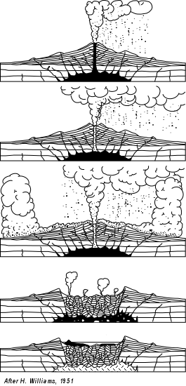
A collapse is triggered by the emptying of the magma chamber
beneath the volcano, usually as the result of a large volcanic
eruption. If enough magma is erupted, the emptied chamber will not
be able to support the weight of the volcanic edifice above it. A
roughly circular fracture - the "Ring Fault" develops around the
edge of the chamber. These ring fractures serve as feeders for
fault intrusions which are also known as ring dykes. Secondary
volcanic vents may form above the ring fracture. As the magma
chamber empties, the center of the volcano within the ring fracture
begins to collapse. The collapse may occur as the result of a
single cataclysmic eruption, or it may occur in stages as the
result of a series of eruptions. The total area that collapses may
be hundreds or thousands of square kilometers.
Explosive Caldera Formation
If the magma is rich in silica, the caldera is often filled in with
ignimbrite, tuff, rhyolite, and other igneous rocks. Silica-rich
magma does have a high viscosity, and therefore does not flow
easily like basalt. As a result, gases tend to become trapped at
high pressure within the magma. When the magma approaches the
surface of the Earth the rapid off-loading of overlying material
causes the trapped gases to decompress rapidly triggering explosive
destruction of the magma and spreading volcanic ash over wide
areas. There is a type of lava in explosive calderas called A'a.
Further lava flows may be erupted.
If volcanic activity continues the centre of the caldera may be
uplifted in the form of a resurgent dome (also known as a somma) as
embodied by Mt. Aso, amongst other locations such as Cerro Galán,
Lake Toba, Yellowstone to name but a few.
Non-Explosive Caldera Formation
Some volcanoes, such as Ki-lauea on the island of Hawaii, form
calderas in a different fashion. In the case of Kilauea, the magma
feeding the volcano is basalt which is silica poor. As a result,
the magma is much less viscous than the magma of a rhyolitic
volcano, and the magma chamber is drained by large lava flows
rather than by explosive events. The resulting calderas are also
known as subsidence calderas, and can form more gradually than
explosive calderas. For instance, the caldera atop Fernandina
Island underwent a collapse in 1968, when parts of the caldera
floor dropped 350 meters. Kilauea Caldera has an inner crater known
as Halema'uma'u, which has often been filled by a lava lake. At the
summit of the largest volcano on Earth, Mauna Loa, is a subsidence
caldera called Moku'a-weoweo Caldera.
Formation of the Aso Caldera
The eruption which formed the present somma occurred approximately
300,000 years ago.
Four large-scale eruptions (Aso 1 - 4) occurred during a period
extending from 300,000 to 90,000 years ago. As large amounts of
pyroclastic flow and volcanic ash were emitted from the volcanic
chamber, a huge depression (caldera) was formed as the chamber
collapsed. The fourth eruption (Aso 4) was the largest, with
volcanic ash covering the entire Kyu-shu- region and even extending
to Yamaguchi Prefecture.
Mt. Taka, Mt. Naka, Mt. Eboshi, and Mt. Kishima are cones formed
following the fourth above-mentioned huge caldera eruption. Mt.
Naka remains active today. It is presumed that Mt. Neko is older
than the fourth huge caldera eruption.
Aso's pyroclastic flow deposits (welded tuff) were utilized for
bridge construction in the region. There are approximately 320
arched stone bridges in Kumamoto Prefecture, including the
Tsujun-kyo and Reidai-kyo bridges on Midorikawa River, which are
important national cultural properties.
Mt. Aso
The central cone group of Aso consists of five peaks: Mt. Neko, Mt.
Taka, Mt. Naka, Mt. Eboshi, and Mt. Kishima. The highest point is
the summit of Mt. Taka, at 1592 m above sea level. The crater of
Mt. Naka, the west side of which is accessible by road, contains an
active volcano which continuously emits smoke and has occasional
eruptions. Only the northernmost crater (the first crater) has been
active for the last 70 years -- 1974, 1979, 1984-1985 and
1989-1991.
Aso Caldera Tasks
- Post a photo of you and your GPS in front of one of the
concrete shelters near the Naka Dake (Mt. Naka) crater rim.
- Post a second Photo of you and your GPS at the intersection on
Routes 212 & 45 (Daikanbo) on the outer rim of the caldera
(please note this location is out side the park).
- What is the height measured by your GPS on the rim of Naka Dake
(Mt. Naka) Crater?
- There are numerous vendors who congregate on the crater rim,
what is the substance they are selling?
- What is the Japanese word for this substance?
- What is the distance measured from the posted co-ordinates to
the location specified in task 2?
Contingency
As Mt. Aso is an active volcano, from time to time access to
various parts of the park or even to the entire park are
restricted. Therefore there are two contingencies.
Access to the Rim
Closed
- Post a photo of you and your GPS in front of the Visitor
centre.
- Post a second Photo of you and your GPS at the intersection on
Routes 212 & 45 (Daikanbo) on the outer rim of the caldera
(please note this location is out side the park).
- What is the height measured by your GPS at the visitor
centre?
- What is the distance measured from the posted co-ordinates to
the location specified in task 2?
Park
Closed
- Post a photo of you and your GPS at the Toll gate showing the
park closed sign.
- Post a second Photo of you and your GPS at the intersection on
Routes 212 & 45 (Daikanbo) on the outer rim of the caldera
(please note this location is out side the park).
- What is the height measured by your GPS at the Toll gate
(please mention which gate it is)
- What is the distance measured from the posted co-ordinates to
the location specified in task
2?
Please email us with the answers to
tasks three through six or four as appropriate.
Please do not post your answers in
your log .
Other Activities
The visitors centre provides some
additional information concerning the formation of the Mt. Aso
Caldera complex. As well as CCTV vision into the crater itself,
along with readouts of current seismic activity in the
regiuon.
Additional Information
Please be aware
that access to the Aso-Kuju National Park is via a toll road.
For visitors who do not have access to a motor vehicle, the park
can be accessed via public transport or even taxi.