21 A Walk in the Garden-Silsean/Moanbane Multi-cache
21 A Walk in the Garden-Silsean/Moanbane
-
Difficulty:
-

-
Terrain:
-

Size:  (regular)
Please note Use of geocaching.com services is subject to the terms and conditions
in our disclaimer.

Visit The Geocaching Ireland discussion
forum HERE
THERE is an Eminence,--of these our hills
The last that parleys with the setting sun;
We can behold it from our orchard-seat;
And, when at evening we pursue our walk
Along the public way, this Peak, so high
Above us, and so distant in its height,
Is visible; and often seems to send
Its own deep quiet to restore our hearts.
The meteors make of it a favourite haunt:
The star of Jove, so beautiful and large
In the mid heavens, is never half so fair
As when he shines above it. 'Tis in truth
The loneliest place we have among the clouds.
And She who dwells with me, whom I have loved
With such communion, that no place on earth
Can ever be a solitude to me,
Hath to this lonely Summit given my Name.
(Wordsworth)
This is a hike of about 9K with an ascent of 530m which should take
about 3 hours. For those geocachers who like it rough and remote
then this is probably for you (listen out for the sound of
"Deliverance" banjos!!). On a nice Summer day this would be a
fabulous hike. Both mountains have tiny loughs on top and in the
case of Moanbane the lough is the only reasonable mark of the
summit. Silsean has a small cairn of sorts but there is little else
of note on top of either mountain. The area around the cairn on top
of Silsean has been destroyed by the motorised lot but it doesn't
really interfere with the enjoyment of the mountain. If you walk
along the top toward the Blessington lake, on a nice day, you will
have some smashing views.
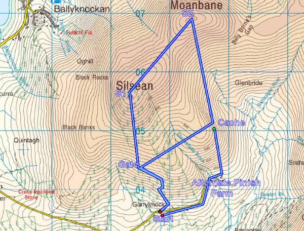
There are several ways to approach it but when placing the cache I
chose the route indicated on the first map above, hiking in a
clockwise direction.
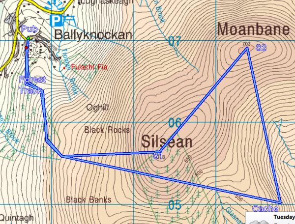
The second map offers another route from the village of
Ballyknockan where there is a nice pub. This route is 11K with a
couple of stiff ascents totalling 800m because the start is at lake
level. Last time I went that way it took over 4 hours so this route
would turn the cache into at least a 4 star for terrain.
After leaving the parking area proceed up the forest track for
about 200 metres and turn left off the track to a path which leads
more directly toward Silsean. This is the old walking path that is
indicated on the OSI map as a broken black line (interesting to
note that the wide, hard surface forest track is not currently seen
on the OSI map at all!) Follow the rougher walking path on up to a
point where it crosses the meandering forest track again. The path
brings you more directly and quickly out to the mountain moorland
and it is also more pleasant if a bit overgrown and sloppy in
places. Shortly, the path turns left and brings you on up to a gate
which leads you out on to open moorland at N53 04.765 W006 28.110.
You will need to keep the coordinates of this gate for the return
trek.
The ground rises before you and soon Silsean and Stage 1, will be
clear ahead of you. I'm afraid it is one of those mountains that
seems to be just there but another top appears as you climb and
then another etc. but don't be put off as the views over the lake
on a good day are superb.
There are not too many features on top of either of the mountains
so I had do improvise a little to provide stages.
NB The OSI map shows forest covering the majority of the top of
Silsean but contary to that, please note that there are no trees at
all on this side of the mountain so don't be fooled by the map!!
Strangely, there are plenty of trees on the other side of the
mountain but these are NOT on the map!! The Coillte forestry land
is actually indicated by the tattered remains of a very old fence
with concrete posts. You are looking for the highest corner of this
fencing which is a couple of hundred metres away from the summit
and it should be to your right (on the Moanbane side) as you
approach from the gate indicated above.
At Stage 1. N53 05.534 W006 28.249 (3 posts from the top corner)
you will find the last 3 numbers from the first half of the final
coordinates. Call these ABC just as you see them and get in close
to make sure that you have them correctly.
The tops of both of these mountains are boggy and usually quite wet
but the walk between the two is not difficult.
Near the top of Moanbane you will find Stage 2 at N53 06.198 W006
27.521. Here, under the lip of a peat hag you will find the last 3
numbers of the second half of the final coordinates. Call these
DEF. PLEASE DON'T REMOVE IT AND LEAVE IT COVERED CORRECTLY
AFTERWARDS!
The hiking down to the cache itself can be rough and lumpy so be on
the lookout for bog holes and twisty ankles. The final cache can be
found at N53 05.ABC W006 27.DEF.
After retrieving the cache you should head back to the gate at the
top of the path from which you started and then back down to the
parking area. The walk back can be up and down or you could skirt
the hills staying pretty much at the same level. If you want to
make the hiking a little easier on yourself I have included an
alternative extra section in the first map above which would take
you down from the cache area the short distance to a farm at N 53
04.745 W 006 27.065 where you can gain access to the road which
will take you back up to the start point. I know that many hikers
don't like to finish with a road section, especially a steep uphill
one, but it is just an alternative.
From Mountain Views:
Silsean Mountain Wicklow County
Soillsean A name in Irish (Ir. Soillsean [PNCW], 'place of
lights')
Height: 698 metres OS 1/50k Mapsheet: 56 for top Grid Ref: O02318
05649 Latitude: 53.091921 Longitude: -6.473510 ITM: 702244
705681
Prominence: 43m Isolation: 1.6km Rating graphic
. Silsean is the 113th highest summit in Ireland.
If you have a look at pictures on Mountain Views from 2003 you will
see nice undisturbed vegetation at the summit marker. Unfortunately
bikers and quads have churned it up and left quite a mess!
Moanbane Mountain Wicklow County
Móin Bhán A name in Irish (Language) (Ir. Móin Bhán [PNCW], 'white
bog')
Height: 703 metres OS 1/50k Mapsheet: 56 for top Grid Ref: O03333
06886 Latitude: 53.102836 Longitude: -6.457968 ITM: 703259
706918
Prominence: 108m Isolation: 1.6km Rating graphic.
Moanbane is the 107th highest summit in Ireland.
Our data has reached 67% of the goal for this summit.
There are some fences to be
crossed but there are large gaps in places..
Do not start the trek without all the proper mountain rain gear,
waterproof boots and the guidance material, compass, map, GPSr with
mapping etc. Please note that all parts of this cache are hiked at
your own risk. The cache owner takes no responsibility of any sort
for any reason including accidents or
mishaps.
Please be aware that cars parked
in areas close to walking trails are vulnerable and they can be
vandalised or stolen. Unfortunately this is an ongoing problem
which is extremely difficult to solve. so there is a risk involved.
I have heard recently that many hiker groups are parking at the
nearest population centres and getting taxis to and from the start
points at very little expense.
Please observe the country code to the best of your ability. Local
landowners often generously allow access to upland areas across or
through parts of their private property. Please, please be
conscious of this and return the courtesy by keeping all gates
closed, immediately and not on your way back!. Please use the gates
where appropriate but if you have to climb over them then use the
hinged side ONLY.
Please do not cause any damage of any sort to fences or barriers
along the way.
Additional Hints
(Decrypt)
Obhyqre