The Riverways claim two of the clearest spring-fed rivers in the world, the Current and the Jacks Fork. Due to the dissolved limestone found in this water, it has an amazing blue tint which is amplified when the water is deeper or when the sky is blue. Also found in the area are many caves, some of which offer tours into their depths. Over 300 caves have been identified within the boundaries of Ozark National Scenic Riverways, ranging from not much more than a rock overhang to one cave with almost seven miles of identified passages. Eight caves, including an open sinkhole, have been designated as outstanding natural features.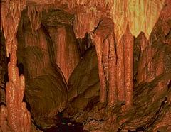
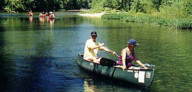
The park consists of 80,000 acres with canoeing, hunting, hiking and fishing being just some of the activities that are enjoyed there.
Many think the Ozark is a state park instead of a national one. Their confusion is not entirely unfounded. Three of the largest campgrounds in the park used to be run by the state, but they were donated to the federal government in 1964 when the Ozark National Scenic Riverways was created.
The Geocache Notification Form has been submitted to The Glacial Drumlin trail office in Lake Mills, of the Wisconsin DNR. Geocaches placed on Wisconsin Department of Natural Resource managed lands require permission by means of a notification form. Please print out a paper copy of the notification form, fill in all required information, then submit it to the land manager. The DNR Notification form and land manager information can be obtained at: http://www.wi-geocaching.com/hiding