Grand Teton EarthCache
-
Difficulty:
-

-
Terrain:
-

Size:  (other)
Please note Use of geocaching.com services is subject to the terms and conditions
in our disclaimer.
Grand Teton
One of my favorite National Parks
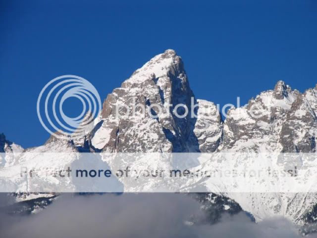
Grand Teton is the highest mountain within Grand Teton National Park, and the second highest in the U.S. state of Wyoming. The origin of the name is controversial. The most common explanation is that "Grand Teton" means "large teat" in French, named by either French-Canadian or Iroquois members of an expedition led by Donald McKenzie of the North West Company. However, other historians disagree, and claim that the mountain was named after the Teton Sioux tribe of Native Americans.
There is a controversy over who made the first ascent of Grand Teton. Nathaniel Langford and James Stevenson claimed to reach the summit on July 29, 1872. However, their description and sketches match the summit of The Enclosure: side peak of Grand Teton. The Enclosure is named after a man-made palisade of rocks on its summit, probably constructed by Native Americans. When William O. Owen climbed the true summit in 1898, he found no trace of prior human passage. Therefore, The Enclosure was probably first climbed by Native Americans, and the true summit was first climbed by William Owen.
The geology of the Grand Teton area consists of some of oldest rocks and one of the youngest mountain ranges in North America. The Teton Range, mostly located in Grand Teton National Park, started to grow some 9 million years ago. An older feature, Jackson Hole, is a basin that sits aside the range.
The 2,500 million year old metamorphic rocks that make up the east face of the Tetons are marine in origin and include some volcanic deposits. These same rocks are today buried deep inside Jackson Hole. Paleozoic rocks were deposited in warm shallow seas while Mesozoic deposition transitioned back and forth from marine to non-marine sediments with the Cretaceous Seaway periodically covering the area late in that era.
70 million years ago, the Laramide orogeny started to uplift western North America, erasing the seaway and creating highlands. The first part of the Teton Range was thus formed in the Eocene epoch. Large volcanic eruptions from in the Yellowstone-Absaroka area to the north left thick volcanic deposits. A series of glaciations in the Pleistocene epoch saw the introduction of large glaciers in the Teton and surrounding ranges, which at times formed part of the Canadian Ice Sheet. Moraines left by less severe ice ages impounded several lakes, including Jackson Lake.

Grand Teton can be seen from almost anywhere in Jackson Hole. There are better areas than the coords to take a pic. I will accept a pic from anywhere as long as the Teton are behind you.
To log the find you must complete the following:
1. Visit the location and make some observations. Tell me evidence you can see that Grand Teton was formed by a Glacier.
Or
2. Describe the evidence of Grand Teton was formed by Volcanic activity.
and
OPTIONAL: Post a picture of your group with your GPSr with Grand Teton in the background.
Additional Hints
(No hints available.)