Scientists tell us that barrier islands moved into their current
location along the South Carolina coast less than 5,000 years ago.
The stabilization of these islands occurred as a result of slowing
of sea-level rise.While 5,000 years is a long time to man, it is
less than a blink of the eye to our planet. Geologists use the
Earth to “tell” us what has happened in the past. Just as the scars
on our bodies can give a history of our events, so the various
landforms can give a history of the Earth’s events.
The easiest way to read the Earth’s history is to look at how
the layers have been deposited and eroded over time. Changes to the
shoreline are inevitable and inescapable. Shoals and sandbars
become islands and then sandbars again. Ice sheets grow and shrink,
causing sea level to fall and rise as water moves from the oceans
to the ice caps and back to the oceans.
Barrier islands rise from the seafloor, are chopped by inlets,
and retreat toward the mainland. Even the calmest of seas are
constantly moving water, sand, and mud toward and away from the
shore, and establishing new shorelines. Such is the story of Waites
Island.
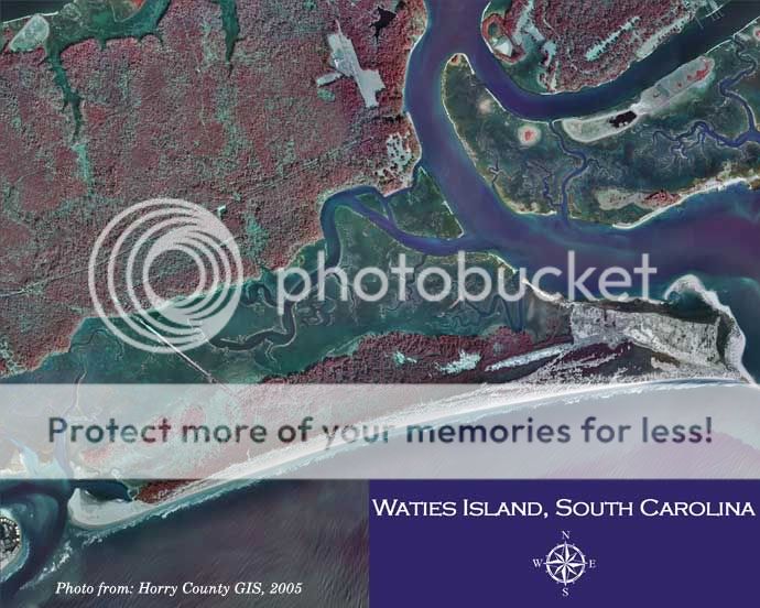
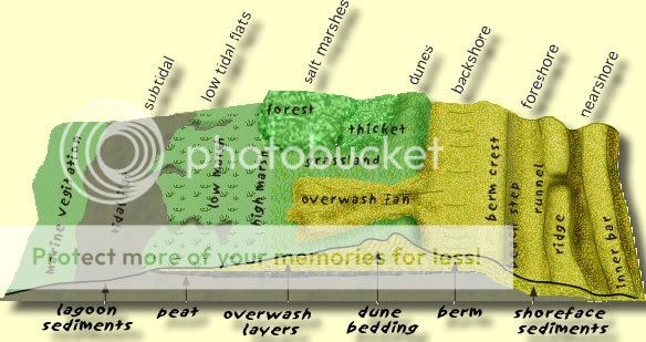
Waites Island is an undeveloped barrier island located at the
northern end of the South Carolina coastline. The 3 mile long
island is bounded by Little River Inlet to the north and Hog Inlet
to the south. A transect from the sea to the landward will
encounter the following environments: beach, dune, a brackish water
(intermediate between salt & fresh water) wetland, a landward
beach/dune ridge system and marsh. This older landward ridge system
was likely formed at different times since 4000 years ago, with the
current beach potentially forming seaward of the landward ridge
within the last 300 years.

Since sea level is currently rising, understanding these
historical changes may allow for better decisions on how to manage
shoreline retreat. Waites Island is younger than ~4,500 old. The
age of the island was determined by radiocarbon dating of fragments
of marsh plant located just under the landward sandy ridge. The
island was created during a time when sea-level rise was generally
slowing allowing for the island to stabilize in its current
location.

In order to study the changes in sedimentary environments over
time, geologists need to obtain samples of the layers. Scientists
decide which area to study, and map out locations for obtaining
samples, often along a line or transect. Samples are obtained by
taking cores, which involves putting a pipe vertically in the
ground, removing the pipe, and examining the layers extracted.
These cores can be composed of many layers, which may represent
many different environments. To determine these environments, the
sediments of the layers are examined for color, sediment type, and
other characteristics (shells, organic material, structures, etc.),
which identify the kind of environment. Once several of the cores
have been , and their characteristics recorded, the environments
can be correlated.
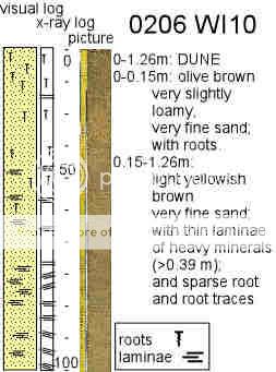
The sediments that make up the core are visually described and
recorded on sheets. Sediment size, type (such as shells, roots,
wood), and structure (layering) are noted in the description to the
right of the core. This core was one of the cores collected from
Waites Island. The top meter of this core is composed of dune sand,
which was identified by the fine size sand (no mud) and the steep
angle of the “bedding” or layering. The environments, as determined
from the sediment, are then correlated between each core.
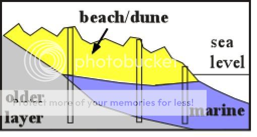
Each color of the correlation represents a different
environment: beach, marsh, subtidal(mud and sand deposited in a
tidal creek or estuary),and fresh water swamp or brackish water
wetlands.
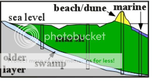
As determined by the Law of Superposition, older freshwater
swamp sediment underlies subtidal and marsh environments of even
younger beach environments. This change of environments over time
is the result of a rising sea level causing Waites Island to shift
landward, and in turn, seaward environments like the beach, to
shift over landward environments like marsh/subtidal areas, and
over still more landward environments like the freshwater
swamp.
The laws of stratigraphy are some of the best tools we have for
understanding rock and sediment layers. These laws help with
relative dating, which cannot determine the age of these layers,
simply the relative order in which the layers formed. In order to
understand these laws, we must assume that the geologic processes
of today were the same in the past. This is called
uniformitarianism. The first law of stratigraphy is the law of
superposition, which states that the oldest layer is at the bottom
of the sequence, and the youngest at the top. The second law is the
law of original horizontality. This law states that sediment or
rock layers were deposited in a horizontal orientation.
If units are not horizontal, an event occurred subsequent to the
deposition which caused the layers to fold or tilt. The third law
is the principle of lateral continuity. This states that deposits
originally extended in all directions. Another way to determine
relative age of rock is by examining cross-cutting relationships.
This describes the relationship between existing rock and rock
which intrudes by magma flow into existing rock. This creates an
intrusion, and the intrusion is always younger than the rock it
invades. Sometimes layers of rock contain unconformities which
represent a time interval where erosion and no deposition has
occurred.
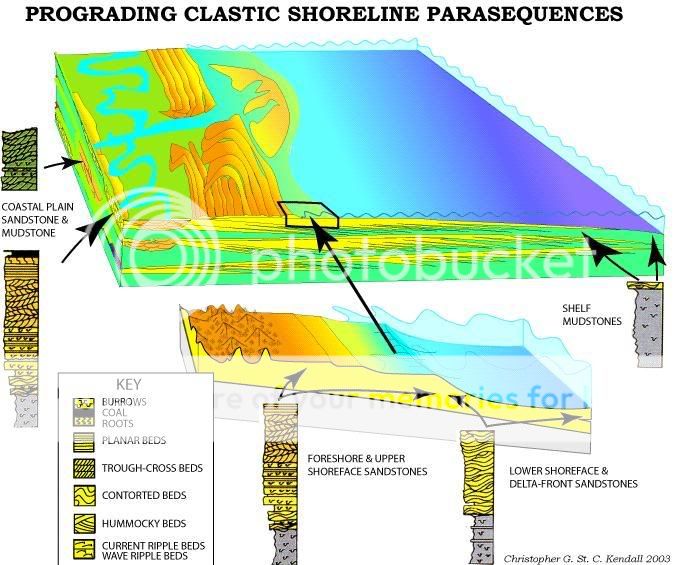
Sea level plays a major role in creating sedimentary history
along the coast. For example, looking laterally from the ocean to
15 miles inland in South Carolina, one might expect to see
environments in the following order: marine, beach, marsh/tidal
creek, and fresh water swamp/upland forest. As sea level rises and
falls, different coastal and upland environments shift
accordingly.
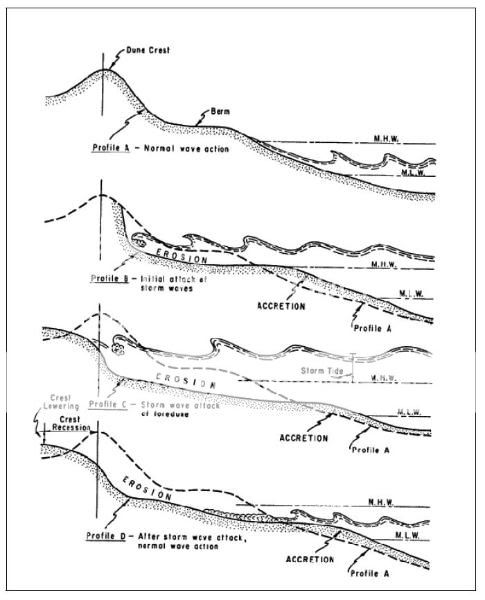
During a sea level transgression, or rise in sea level and
associated landward migration of the shoreline, these environments
would begin to move landward, depositing their unique sediments
over the existing layers. The marine environment would extend over
the beach and the beach over the marsh, and so forth.
The opposite is true for a sea level regression, or fall in sea
level and associated seaward migration of the shoreline. The beach
would extend over the marine environment.
When a core is obtained from a coastal area, these environments
can be identified through sedimentary examination, and a history of
sea level transgressions and regressions appears based upon seaward
over landward environments (a transgression) or landward over
seaward environments (a regression).
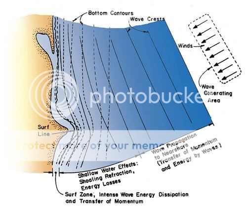
Many studies of nearshore processes have been conducted on long,
straight shorelines, and scientists have made some progress in
understanding how waves, sandbars, and currents interact in
simplified situations. But the mechanisms driving shoreline change
are not well understood in regions where the nearshore region has
complicated seafloor topography, inlets, or headlands—which means
most beaches.
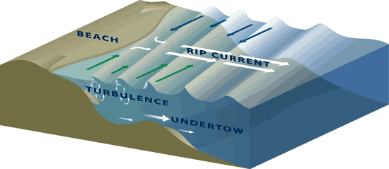
Waves traveling across the continental shelf are reflected,
refracted, and amplified. Wave-induced currents cause sediments to
erode and accrete and reshape the seafloor near the coast, changing
how future waves will evolve.
Many studies of nearshore processes have been conducted on long,
straight shorelines, and scientists have made some progress in
understanding how waves, sandbars, and currents interact in
simplified situations.
The long-term fate of today’s barrier islands is dependent on
future sea-level rise.

To catch a glimpse of Waites Island, you can only do so from
across the marsh, as the only visitors to the island are
researchers. The island is now owned by South Carolina Coastal
University and is totally dedicated to the study of biology and
coastal erosion.
Travel to Frink Park- a small, little known North Myrtle Beach
City Park named after one of the area forefathers. From the
platform boardwalk in the marsh make the following estimations,
then take a long shot of the island with your GPS in the picture
and post it with your log. And be sure to visit EZ Track's
Traditional Cache also located here!

1. Estimate the distance across the marsh here to the island.
This is how far the island is from the mainland. Are the sand dunes
and tree line of Waites Island: A/Less than or B/Greater than 1,000
yards away?
2. Shoot an elevation at the bottom of the landing at the lowest
point near the water. That is about the level of the coastal shore
on the island.
3. Shoot an elevation at the top of the stairs to the boardwalk.
That would be how high the mainland stands above the barrier
island.
4. Estimate the height of the sea grass growing along the board
walk in the marsh area.

To properly protect barrier beaches—or learn when to abandon
them—coastal geologists need to map and monitor them regularly.
They will need to dig into the sediments of the coast to piece
together the history of past changes. Such efforts will allow them
to model how tidal systems are likely to respond to rising ocean
waters in the future. The key to the future of the coast lies in
it’s past.