✴️ Earthcaches Explained: ✴️
This is an EarthCache. 🌎 As such there is no physical container or physical log. To earn credit for finding this cache, you must visit the posted coordinates, make personal observations, and formulate conclusions based on your observations and careful reading of the cache description. Then, send me the answers to the questions listed under "Logging Requirements" via my geocaching.com profile per the guidelines. Do not post your answers online. You don't need to wait for my response to log your find. I will contact you if there is a problem with your answers.
✴️ Logging Requirements: ✴️
Please use the date of your observation for the found date, not the date that you finally get a chance to submit and log it. I’d love to hear a bit about your trip in your online log.
- Cache title, date, time, and with whom did you make this observation?
- What do you think were the primary processes responsible for creating the monastery door feature and why?
- What is your best estimate of the size of this feature?
- Observing the drainages immediately upstream and downstream of this feature, do you expect the Monastery Door will ever become an arch?
- Post a picture of you (or some personal identifying item) at the posted coordinates with the downstream curve in the background or send said picture with your response to me. This picture is REQUIRED in accordance with current guidelines for EarthCaches.
✴️ Observation Point Access: ✴️
This is not a quick “let’s grab an EC on our way by” EarthCache. The observation point is about 3 river miles downstream from the last launching point (Mineral Bottom) on the lower Green River and about 3 river miles upstream from the entrance to Canyonlands National Park. Permits are required! Fifty-two river miles below Mineral Bottom, the Green River reaches the confluence with the Colorado River. Three miles downstream of the confluence, Cataract Canyon features some of the biggest whitewater in the US during spring run-off. Canoe traffic typically uses a jet boat shuttle reservation to return upstream on the Colorado to Moab from the confluence. Research your options and plan carefully before attempting this EarthCache! There's some trip planning info on my blog published on the same date.
The observation point is located on the downstream end of a sand island. The position, height and shape of the island will vary from one year to the next. It may be totally submerged during high water. If this EarthCache is attempted during the high water season, it may be challenging to hold position at the posted coordinates. We often use this island as a lunch stop on our Stillwater Canyon canoe trips.
There is a road of unknown condition that passes about 800 feet south of the posted coordinates but access in this manner would require working through at least 400 feet of thick tamarisk and crossing the river. This approach is NOT advised.
✴️ General Information: ✴️
According to Felix Mutschler, John Wesley Powell’s party likened this feature in the Wingate Sandstone layer to the doorway of a monastery when they passed by on his second trip down the Green and Colorado rivers. At the observation point, the top of the cliff on river right is approximately 800 feet above the river.
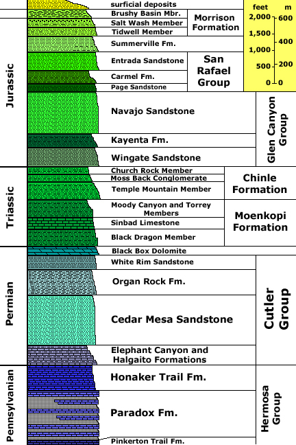 |
| Image: Stratigraphy of Canyonlands area; Credit: U.S. Geological Survey, Department of the Interior/USGS |
The Labyrinth and Stillwater Canyons sections of the Green River are a candy store of geology. Layers of rock laid down as sand dunes, marshes, or underwater sediment gradually rise from the river. The river is sinuous. The typically very muddy water tries to obscure the many shoals that move from one year to the next and season to season. The canyon walls mesmerize until another shoal competes for your attention.
Navaho Sandstone is light colored and is the upper layer of the Glen Canyon Group. It was created from massive wind-blown sand dunes and is youngest, dominate layer in the area (especially in the Arches NP area) although not much remains in the area of this Earthcache.
The Kayenta Formation is a ledge forming reddish-brown layer that was laid down in a braided stream environment. It’s the top layer commonly visible from the river in the Mineral Bottom area.
The Wingate Sandstone is the lowest layer of the Glen Canyon Group. It is a reddish layer created from massive sand dunes (like the Sahara today) and exhibits as towering, shear cliffs and spires. Wingate Sandstone forms the shear cliffs along the Green River visible at the Mineral Bottom boat launch.
The Chinle Formation is composed of several members which have different characteristics depending on the dispositional environment – typically streams and marshes. These members vary depending on the age of the documents and the exact area being depicted. The Chinle presents as multi-colored talus slopes of clay with occasional sandstone ledges, underlying the Wingate. The Moss Back member of the Chinle commonly contains uranium in this area, attracting many prospecting efforts in the early 1950s.
As you travel further downriver, the Moenkopi, White Rim, and other layers appear.
According to the Utah Geological Society, “...the Colorado Plateau is home to the densest concentrations of natural arches found anywhere in the world.”
I went looking for accepted definitions of arch, bridge, and alcove as applied to natural rock structures.
The World Landforms website does not define bridge or alcove but does define “natural arch” as a rock formation that has a naturally occurring curved shape, created between two cliffs with an open air space located underneath the bridge. They go on to say, “Natural arches are formed when soft rock material is eroded rapidly by wind or water. Natural arches generally form where they are susceptible to this type of swift wearing away. The natural agents of erosion work on wear rocks along coastlines, in caves, and in areas that have water running through them. Natural arches can also form in areas that have high winds or experience intermittent freezing and thawing which weakens rock.”
The Natural Arch and Bridge Society website was the only place I could locate a definition of an “alcove natural arch” but they seem to insist that to qualify it must have an opening to the sky. They have a fairly extensive explanation of processes impacting the formation of arches, bridges, and alcoves. Unlike World Landforms, NABS clearly states, "Wind is not a significant agent in natural arch formation."
While somewhat dated, Barnes’ report in his book seems to sum it up.
To give a couple of examples, the “Illustrated Encyclopedia of the Earth Sciences – The Planet We Live On” defines “natural bridge,” but notes that “they are of little geologic importance, however, because they are short-lived, incidental features doomed by the processes that created them.” Of course in geologic terms, even span that lasted for twenty thousand years would be “short-lived.” The “Encyclopedia of Geomorphology” also defines the term “natural bridge” but goes on to say that they are “topographic features whose human interest greatly exceeds their geologic importance.
Various references used the terms weathering and erosion interchangeably. Salt Lake Community College in their free on-line geology textbook had definitions that differentiate. Weathering is a group of processes that reduce bedrock to smaller parts. It can use mechanical processes such as pressure expansion, wedging, or salt expansion. Chemical weathering includes acids, hydrolysis, dissolution, and oxidation. Erosion is the mechanical process of moving the pieces from the point of weathering. It is driven by water, wind, gravity, or ice.
Apparently, you’re on your own as to how you classify and explain the formation of the monastery door feature.
✴️ Potentially Helpful Terms: ✴️
Bedding plane expansion: Sedimentary rock is deposited in layers. The boundaries between these layers, known as bedding planes, are similar to joints or cracks. Water seeping between the bedding planes can cause chemical exfoliation and/or freeze expansion. This can lead to a horizontal air gap between layers of rock.
Chemical exfoliation: Water in contact with rock will eventually dissolve the lattice of fine grains that cement the larger grains of the rock together which can then be removed either by the water itself, gravity, wind, or other erosion mechanisms.
Compression strengthening: The weight of rock is due to the force of gravity which normally acts in a vertical direction. Rock underneath other rock is compressed by the rock above. When rock is supported over an opening, the lines of compression are diverted into the shape of an inverted catenary. The compression strengthens the rock, increasing its resistance to weathering.
Differential erosion: Rates of erosion will vary depending on the strength and makeup of the rock. This is often obvious between the various rock stratus.
Exfoliation: sometimes known as onion skin weathering, exfoliation results in the removal of sheets of rock. These sheets can be vary from a few mm thick to several meters thick depending on the underlying material and type of exfoliation.
Freeze expansion: If water can seep into a joint and freeze, the expansion of the ice builds stress along the joint. Freeze/thaw cycles (assuming water is replenished in the joint) can continue to grow the joint.
Inverted Catenary: A catenary is the shape that a chain or cable takes when suspended only at its ends. An inverted catenary is that shape turned upside down.
Mass Wasting: The downhill movement of rock and soil material due to gravity. Mass wasting is a broad term referring to all movement downslope. Landslide is a general term for mass wasting that involves fast-moving geologic material. Rock topples, rock slides, or rock falls (depending on the dominate motion of the blocks) are also examples of mass wasting as are debris flows. Movement by mass wasting can be slow or rapid.
Stress relief exfoliation: Rock is subjected to many forces. Tectonic movement, uplift, and gravity can each put stress on a rock exposure. Rock will eventually fracture as more and more stress is placed upon it.
Tectonic movement and uplift: The earth's crust consists of plates that float on a sea of magma. As these crustal plates slowly move over the magma they collide in places, causing portions of the plates to be raised up. This is one example of what is known as uplift. Tectonic movement can also result in thinner areas of crust gradually becoming re-positioned over hot spots in the magma. When this happens, these areas also experience a general uplift due to the increased pressure from below. Uplift induces stresses that can increase weathering.
Thermal exfoliation: According to NABS, thermal exfoliation is the macroscopic fracturing and removal of rock as the result of temperature fluctuation or temperature gradients. Sunlight striking the surface of a rock will create a temperature gradient in the rock with the surface layer of rock becoming hotter than deeper layers. The surface layer expands more than the cooler, deeper layers. In effect, the surface tries to bow outward. This can lead to stress fractures parallel to the surface. Other sources suggest thermal exfoliation is not a factor in rock erosion.
Vertical joint expansion: Typically caused by chemical exfoliation or freeze expansion exfloiation, etc.
✴️ References: ✴️
Books
- Barnes, F. A., Canyon Country Arches & Bridges, Canyon Country Publications, 1987
- Belknap, Bill and Buzz Belknap, Belknap’s Revisws Waterproof Canyonlands River Guide, Westwater Books, 1996
- Martin, Tom & Duwain Whitis, Guide to the Colorado & Green Rivers in the Canyonlands of Utah & Colorado, RiverMaps LLC, 2016
- Mutschler, Felix E., River Runner’s Guide to Canyonlands National Park and Vicinity With Emphasis on Geologic Features, Powell Society Ltd., 1977
Web Resources
- An Introduction to Geology, Salt Lake Community College, 2017, accessed 21 Oct 2020, https://opengeology.org/textbook/
- Chinle Formation, Wikipedia, 16 Sept 2020, accessed 21 Oct 2020, https://en.wikipedia.org/wiki/Chinle_Formation
- Exfoliation, Britannica, accessed 24 Oct 2020, https://www.britannica.com/science/exfoliation
- Geology, National Park Service, 1 Aug 2019, accessed 21 Oct 2020, https://www.nps.gov/cany/learn/nature/geologicformations.htm
- GLAD YOU ASKED: WHY ARE THERE SO MANY NATURAL ARCHES IN UTAH?, Utah Geological Survey, Jan 2016, accessed 21 Oct 2020, https://geology.utah.gov/map-pub/survey-notes/glad-you-asked/glad-you-asked-why-natural-arches-in-utah/
- Landforms of the World, World Landforms, 2015, accessed 21 Oct 2020, http://worldlandforms.com/
- The Natural Arch and Bridge Society, accessed 21 Oct 2020, https://www.naturalarches.org/index.htm
- Wingate Sandstone, Wikipedia, 8 Apr 2020, accessed 21 Oct 2020, https://en.wikipedia.org/wiki/Wingate_Sandstone