While traveling to Sitka on business I noticed this beautiful mountain (volcano). I thought what a perfect spot for an Earthcache. Your GPS will take you to a public parking area that provides a GR8 view of the volcano. This Earthcache was created to be accessible to people with disabilities.
This is an Earthcache so there is no container to find. In order to log a find for this cache you must answer the questions at the end of the lesson and send them to us through the geocaching.com message center. Please do not include the answers in your log. Please note if we do not receive the answers to the questions we will remove your log.
Mount Edgecumbe is a volcano located at the southern end of Kruzof Island, Alaska. The volcano is about 16 km (10 miles) east of the Queen Charlotte Fault that separates the North American and Pacific Plates, and is the highest point in the Mount Edgecumbe volcanic field, an area of about 260 km² (162 sq miles) on Kruzov Island that also includes Crater Ridge and Shell Mountain.1
The highest point of Mount Edgecumbe is at an elevation of 3,201 ft or 976 m.
From Wood and Kienle (1990)1 : "The Edgecumbe volcanic field on southern Kruzof Island is on the North American plate 10-15 km inboard of the Queen Charlotte-Fairweather transform fault. The Edgecumbe volcanic field is dominated by Mount Edgecumbe and the domes and crater of adjacent Crater Ridge. Mount Edgecumbe was named by Captain James Cook in 1778. Despite the fresh constructional morphology of the cone, there is no evidence for historic eruptions in Russian documents or in native oral traditions. Thus, the last certain activity of the Edgecumbe volcanic field was two minor tephra-forming eruptions between 4 and 6 ka. The basal shield comprises ~35 cubic km and consists of basalt, basaltic andesite, and andesite lava flows and breccias. The composite cone of Mount Edgecumbe is dominantly of andesite composition and has a volume of ~3.5 cubic km. The low-silica rhyolite domes of Crater Ridge also contain ~3.5 cubic km of magma.
"The latest significant eruptive activity was postglacial and produced voluminous pyroclastic deposits (7.6 cubic km dense-rock equivalent). The main geomorphic features of the Edgecumbe volcanic field were formed during this activity and include basaltic andesite scoria cones, a crater explosively reamed from the Crater Ridge domes during eruptions of rhyolitic pyroclastic flows, and eruption of andesite and dacite tephra during dome emplacement and crater formation on the Mount Edgecumbe cone. Tephra deposits produced by the late Pleistocene-early 10,000 years of Earth history.">Holocene activity of the Edgecumbe volcanic field have been found as far away as Juneau and Lituya Bay, 200 km to the north. Vents active during the pyroclastic eruptions have a northeast-southwest alignment that probably marks a regional fissure."
It is estimated that Mount Edgecumbe erupted in 7620 BC, 3810 BC and the most recent eruption was in 2220 BC +/_ 100 years. Mount Edgecumbe is expected to erupt sometime in the future.
References
https://en.wikipedia.org/wiki/Mount_Edgecumbe_(Alaska)
https://www.volcanodiscovery.com/edgecumbe.html
Crater Ridge:
About 13,180 years ago, an eruption on Crater Ridge just north of Mount Edgecumbe resulted in deep deposits of rhyolitic airfall, what we know as pumice and ash, and pyroclastic flows or fluidized rock fragments and hot gases. These fast moving flows swept down from the saddle between Crater Ridge and Mount Edgecumbe, rapidly burying the forest and vegetation on the lower slopes.
References:
https://www.usda.gov/media/blog/2014/03/7/buried-forest-alaskas-kruzof-island-window-past
Types of Volcanoes:
There are four main types of volcanoes.
Cinder cones are the simplest type of volcano. They are built from particles and blobs of congealed lava ejected from a single vent. As the gas-charged lava is blown violently into the air, it breaks into small fragments that solidify and fall as cinders around the vent to form a circular or oval cone. Most cinder cones have a bowl-shaped crater at the summit and rarely rise more than a thousand feet or so above their surroundings. Cinder cones are numerous in western North America as well as throughout other volcanic terrains of the world.
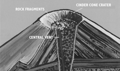
Schematic representation of the internal structure of a typical cinder cone.
Composite Volcanoes:
Some of the Earth's grandest mountains are composite volcanoes--sometimes called stratovolcanoes. They are typically steep-sided, symmetrical cones of large dimension built of alternating layers of lava flows, volcanic ash, cinders, blocks, and bombs and may rise as much as 8,000 feet above their bases. Some of the most conspicuous and beautiful mountains in the world are composite volcanoes, including Mount Fuji in Japan, Mount Cotopaxi in Ecuador, Mount Shasta in California, Mount Hood in Oregon and Mount St. Helens and Mount Rainier in Washington.
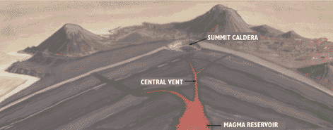
Most composite volcanoes have a crater at the summit which contains a central vent or a clustered group of vents. Lavas either flow through breaks in the crater wall or issue from fissures on the flanks of the cone. Lava, solidified within the fissures, forms dikes that act as ribs which greatly strengthen the cone.
The essential feature of a composite volcano is a conduit system through which magma from a reservoir deep in the Earth's crust rises to the surface. The volcano is built up by the accumulation of material erupted through the conduit and increases in size as lava, cinders, ash, etc., are added to its slopes.
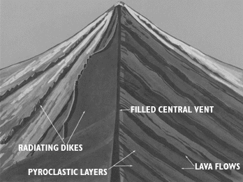
Schematic representation of the internal structue of a typical composite volcano.
Shield volcanoes
The internal structure of a typical shield volcano
Shield volcanoes, the third type of volcano, are built almost entirely of fluid lava flows. Flow after flow pours out in all directions from a central summit vent, or group of vents, building a broad, gently sloping cone of flat, domical shape, with a profile much like that of a warrior's shield. They are built up slowly by the accretion of thousands of highly fluid lava flows called basalt lava that spread widely over great distances, and then cool as thin, gently dipping sheets. Lavas also commonly erupt from vents along fractures (rift zones) that develop on the flanks of the cone. Some of the largest volcanoes in the world are shield volcanoes. In northern California and Oregon, many shield volcanoes have diameters of 3 or 4 miles and heights of 1,500 to 2,000 feet. The Hawaiian Islands are composed of linear chains of these volcanoes including Kilauea and Mauna Loa on the island of Hawaii-- two of the world's most active volcanoes. The floor of the ocean is more than 15,000 feet deep at the bases of the islands. As Mauna Loa, the largest of the shield volcanoes (and also the world's largest active volcano), projects 13,677 feet above sea level, its top is over 28,000 feet above the deep ocean floor.
Lava domes

Schematic representation of the internal structure of a typical volcanic dome.
Volcanic or lava domes are formed by relatively small, bulbous masses of lava too viscous to flow any great distance; consequently, on extrusion, the lava piles over and around its vent. A dome grows largely by expansion from within. As it grows its outer surface cools and hardens, then shatters, spilling loose fragments down its sides. Some domes form craggy knobs or spines over the volcanic vent, whereas others form short, steep-sided lava flows known as "coulees." Volcanic domes commonly occur within the craters or on the flanks of large composite volcanoes. The nearly circular Novarupta Dome that formed during the 1912 eruption of Katmai Volcano, Alaska, measures 800 feet across and 200 feet high. The internal structure of this dome--defined by layering of lava fanning upward and outward from the center--indicates that it grew largely by expansion from within.

The Novarupta Dome formed during the 1912 eruption of Katma Volcano, Alaska.
Active/Dormant/Extinct Volcanoes:
Although the definitions are not set in stone, an active volcano is one that has erupted since the last ice age or about 10,000 years in the past. A dormant volcano is one that has not erupted in the past 10,000 years but is expected to erupt again in the future. An extinct volcano is one that has not erupted in the past 10,000 years and is not expected to ever erupt again. These are the definitions used by the Global Volcanism Program.
References:
http://volcano.oregonstate.edu/how-volcano-defined-being-active-dormant-or-extinct
https://www.avo.alaska.edu/volcanoes/volcinfo.php?volcname=Edgecumbe
Logging questions:
-
Based on the descriptions of volcanoes in the lesson, what type of volcano is Mount Edgecumbe?
-
Based on the information provided regarding the most recent eruptions, would this volcano be considered active, dormant or extinct?
-
Based on your observations and information in the lesson, what structure do you see at the summit of Mount Edgecumbe?
-
Based on your observations at the location, What percentage of Mount Edgecumbe is covered in snow?
-
At the posted coordinates take an elevation reading.Assume that this is the same elevation as the base of Mount Edgecombe.It is very close. Based on your elevation reading at the posted coordinates and the information provided in the lesson, how high is Mount Edgecumbe from base to peak?
-
From the posted coordinates look to the right (North) of Mount Edgecumbe, this is Crater Ridge. Based on the information provided in the lesson, hypothesize why Crater Ridge appears the way it does today. Do you suspect that the activity that gave Crater Ridge its shape was violent or benign? Why do you think this?
-
(Optional – Please include a picture of yourself with Mount Edgecombe behind you)
e>
| I have earned GSA's highest level: |
 |