BLESSING OR CURSE SERIES (#1) ? ANOTHER BIG PIT EarthCache
BLESSING OR CURSE SERIES (#1) ? ANOTHER BIG PIT
-
Difficulty:
-

-
Terrain:
-
Size:  (other)
Please note Use of geocaching.com services is subject to the terms and conditions
in our disclaimer.
Margam Opencast Coal Site is located near the villages of Cefn Cribwr and Kenfig Hill, approximately 3 miles NW of Bridgend, Wales. The site straddles the borders of Bridgend and Neath Port Talbot Counties
THIS IS INTENDED TO BE PART OF A NEW SERIES OF "ACCESSIBLE" EARTHCACHES. There is a large lay-by, which provides good access to the viewpoint. This is a busy road, take care. Look north, from the lay-by the pit is about 1500 yards away. You may find it best to visit when the morning sun is low, as there is much more contrast on the rock face.
HOWEVER, IF TIME AND MOBILITY PERMITS, THERE IS A MARKED FOOTPATH ON THE DOWNHILL SIDE OF THE LAY-BY, WHICH WILL GIVE YOU A MUCH BETTER VIEW!
There are other less accessible overlooks and you could get much closer. However, viewing from a distance highlights the enormity of the project, particularly in its context. For example you can approach the site entrance from Cefn Cross or view from the traditional cache GC305DY .
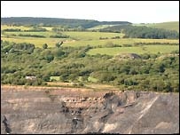
The pit is approximately 196 hectares in extent, although the area of excavation is just 40 hectares, the remainder of the site comprising soil and overburden storage areas, coal stocking and screening facilities, water treatment areas and an office and workshop complex. Open-pit mines are dug on benches, which describe vertical levels of the hole. These benches are usually on four metre to sixty metre intervals, depending on the size of the machinery that is being used.
Most walls of the pit are generally dug on an angle less than vertical, to prevent and minimise damage and danger from rock falls. This depends on how weathered the rocks are, and the type of rock, and also how many structural weaknesses occur within the rocks, such as a fault, shears, joints or foliations.
De-watering bores may be used to relieve water pressure by drilling horizontally into the wall, which is often enough to cause failures in the wall by itself.
The haul road forms a ramp up which trucks can drive, carrying coal and waste rock. This is very clear in the satellite view
The walls are stepped. The inclined section of the wall is known as the batter, and the flat part of the step is known as the bench or perm. The steps in the walls help prevent rock falls continuing down the entire face of the wall. In some instances additional ground support is required and rock bolts, cable bolts and 'shotcrete' are used.
There is a cycle track that allows you a really close view , if you wish.
TECHNICAL INFORMATION
The South Wales coalfield is the largest continuous coalfield in Great Britain. It has an area of approximately 1000 square miles covering much of the old counties of Glamorgan, Monmouth and Carmarthenshire with a small incursion into South Pembrokeshire. At its broadest north-south extent, the coalfield is eighteen miles in width and the area is criss-crossed with numerous deep valleys running North- South and East-West where coal has been primarily mined and communities established. These narrow valleys are separated by upland moors and hills that, both in the past and present, make direct communication between them very difficult.
The coalfield is bowl-shaped which dictated that mining began at the rim of the bowl, or edges of the coal field, where coal is nearest to the surface. In the centre of the coalfield, or the bottom of the bowl, the coal is much deeper and more difficult to mine. An additional problem is that in an area of mountains and valleys, the coal seams are fractured and uneven, making mining both expensive and labour intensive.
South Wales coal is of three varieties. Anthracite, the deepest in the ground, is of the highest carbon content and is used for central heating, thus making it the last to be exploited from around 1880 onwards. Bituminous is nearest to the surface and is particularly appropriate for the smelting of metals. Steam coal is found in the heart of the coal field and was invaluable for use in the boilers of railway engines and shipping. As demand for these various types of coal arose at different periods, the respective regions of the coalfield developed separately.
Deformed coal seams are also affected by distinctive, large-scale, tectonic fracture sets. The extent of fracturing within coal seams can be assessed using different techniques including measuring fracture frequency directly, performing various strength and hardness tests, making relatively simple subjective assessments on the appearance of the coal or monitoring the size distribution of the coal product.
By applying some of these methods within working opencast sites, it can be shown that large amounts of abnormally fractured coal were formed along coal-based thrust flats or detachments but that the distribution of fractured coal along detached seams is rarely homogeneous. Enhanced fracturing often occurred in association with the localised thickening of seams along small-scale thrusts or within coal duplexes.
There is an outstanding record of Late Carboniferous mainly terrestrial sequences, with extensive collections of historically collected plant fossils and coals available for study. This includes a continuity of succession from the base of the Westphalian through the Bolsovian into the Stephanian. However there has been only minimal modern study in terms of extracting climate and environmental signals from this resource, which shows analogies to present day climate change. Interest in the Coalfield from this respect has grown due to activity relating to a potential Geopark, and new fossil sites have been discovered and enhanced by excavation.
Please EMAIL me the answers ~ From the guidelines: You do not need to wait for permission to log. Requiring someone to wait is not supported by the EarthCache guidelines. You should send your logging task answers , then log the EarthCache. When I review your logging task answers, if there is a problem, I will contact you to resolve it. If there is no problem, then your log simply stands."
PLEASE DO NOT include the answers in your log or upload any photos that would allow others to claim the cache without visiting
I will only contact you and delete your find IF the answers are incomplete.
1. How deep would you estimate the pit to be?
2. How many ‘benches’ can you actually see on the north/west walls? Why do you think the benches are cut where they are?
3. The coal extracted here is NOT anthracite. Can you suggest why?
4. Behind the recommended viewing point, (south), are some small houses, what are the names of the houses?
5. BLESSING OR CURSE? What do you think? Good for the economy and employment for local people, but also a massive environmental impact. Check out this musical link which sums the dilemma up really well
THERE IS A TRACKABLE ASSOCIATED WITH THIS CACHE IF YOU WISH TO DISCOVER IT REMIND ME WHEN YOU SEND YOUR ANSWERS
There are also several traditional caches in close proximity

Additional Hints
(No hints available.)