
Orrido di Pré-Saint-Didier
letto della Dora Verney + passerella panoramica
 Celebre dai tempi del primo turismo termale sette-ottocentesco, quest’orrido intorno ospita l’unica sorgente calda (circa 35°C) della Valle d'Aosta, conosciuta almeno dal XVI secolo se non già dai Romani o ancor prima. La temperatura “tiepida” dell’acqua sorgiva è forse dovuta alle tensioni che scaldano la roccia in una zona di recente sollevamento ed in prossimità del Fronte Pennidico, dove la placca europea sprofonda sotto l’edificio alpino. Alcuni resti di infrastrutture ottocentesche sono ancora visibili appena a valle della forra. Il torrente che percorre l’orrido è la Dora di Verney (o di La Thuile) che poi costeggia il capoluogo e si getta nella Dora Baltea. Celebre dai tempi del primo turismo termale sette-ottocentesco, quest’orrido intorno ospita l’unica sorgente calda (circa 35°C) della Valle d'Aosta, conosciuta almeno dal XVI secolo se non già dai Romani o ancor prima. La temperatura “tiepida” dell’acqua sorgiva è forse dovuta alle tensioni che scaldano la roccia in una zona di recente sollevamento ed in prossimità del Fronte Pennidico, dove la placca europea sprofonda sotto l’edificio alpino. Alcuni resti di infrastrutture ottocentesche sono ancora visibili appena a valle della forra. Il torrente che percorre l’orrido è la Dora di Verney (o di La Thuile) che poi costeggia il capoluogo e si getta nella Dora Baltea.
L’orrido consiste nel profondo taglio di una piccola dorsale ad andamento ovest-est costituita da marmi impuri, calcescisti e conglomerati a clasti calcarei appartenenti all’Unità Sion-Courmayeur. Perché quella piccola dorsale sia lì non è chiaro, ma in ogni caso essa ha funzionato da soglia glaciale alla confluenza dell’antico ghiacciaio del Ruitor con quello balteo. Il torrente ha inciso fino in fondo questa soglia per circa 160 m di profondità, lasciando belle pareti verticali sui lati.
Dato che maggior parte dello scavo è stata fatta dopo la scomparsa del ghiacciaio, la velocità di approfondimento deve essere stata notevole, almeno nei primi tempi, dell’ordine di un centimetro all'anno, facilitata dalla natura solubile della roccia.
Questi sono i 5 quesiti ai quali siete pregati di rispondere per loggare questo earthcache:
1) Prima di tutto un orrido è una valle, ovvero una depressione del terreno delimitata da pendii laterali montuosi. In base alla loro genesi le valli si distinguono in due categorie:
- Origine fluviale, solitamente con un profilo trasversale a forma di V
- Origine glaciale, solitamente con un profilo trasversale a forma di U.
Domanda: A quale dei due gruppi appartiene l'Orrido di Pré-Saint-Didier ?
2) Le valli fluviali sono suddivise in varie tipologie come per esempio:
- La forra (orrido) (immagine a),
- La gola (immagine b),
- La semplice valle a V (immagine c),
- Il canyon (immagine d),
- e altre,

in base al grado di presenza di seguenti fenomeni:
- Erosione in profondità (incisione),
- Erosione laterale (meandri),
- Denudazione sui versanti.
Domanda: Quale tra questi 3 fenomeni è il più significativo in una gola ?
WAYPOINT 1, coordinate del listing, letto del torrente:
3) Il livello di base è il livello di altezza fino al quale l'erosione di un acqua corrente è efficace. Nessun fiume può erodere più in profondità dell'altitudine del suo sbocco. Al di sopra del livello di base, il fiume tenta di creare una curva di pendenza ideale per erosione, una curva di equilibrio nel profilo longitudinale tra la sorgente e lo sbocco.
Domanda: Quanti metri si trova il fiume sopra il proprio livello di base ?
Aiuto: Solitamente (tranne l'eventualità di alcune attività tettoniche) il livello di base corrisponde al livello del mare.
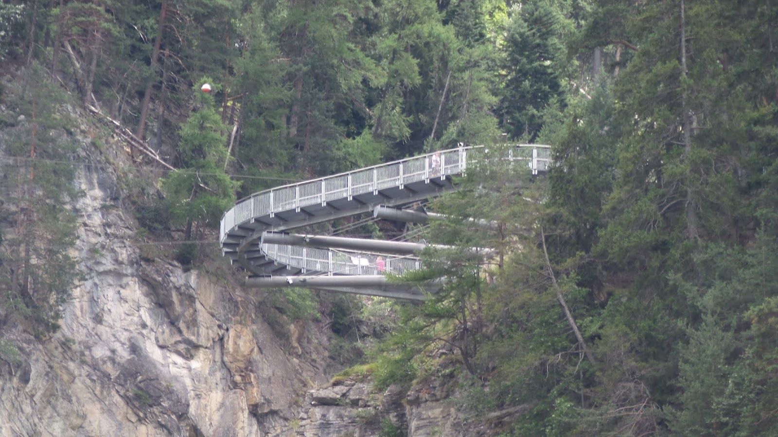
WAYPOINT 2, passerella panoramica:
4) Domanda: A quale altitudine ti trovi qui? Determina all'incirca l'altezza delle pareti rocciose che racchiudono l'orrido mettendo in rapporto l'altitudine con quella del WP 1
5) Scatta delle foto di te o di qualunque altra cosa che ti è piaciuta particolarmente e allegala al tuo log.
Invia le tue risposte a:
Earthcache@CaniSciolti.org
Sentiti libero di registrare la cache come trovata e di inviarci le tue risposte proposte via e-mail, il nostro profilo o il centro messaggi di geocaching.com senza attendere la nostra risposta e ti contatteremo in caso di problemi.
Le domande non fanno riferimento ad un pannello informativo posto in loco o qualcosa di simile. Leggi il listing e usa il gps.
Grazie per l'attenzione e buon divertimento alla scoperta di questo bellissimo luogo naturalistico !
 Famous from the time of the first seven-nineteenth-century thermal tourism, this ravine around is home to the only hot spring (around 35 ° C) in the Valle d'Aosta, known at least from the sixteenth century if not already by the Romans or even earlier. The "lukewarm" temperature of the spring water is perhaps due to the tensions that warm the rock in a recently raised area and near the Pennidic Front, where the European plate sinks under the alpine building. Some remains of nineteenth-century infrastructures are still visible just downstream of the gorge. The stream that runs through the ravine is the Dora of Verney (or La Thuile) which then runs along the capital and flows into the Dora Baltea. The ravine consists in the deep cut of a small ridge with a west-east course made up of impure marbles, calcescists and conglomerates with limestone clasts belonging to the Sion-Courmayeur Unit. Because that small ridge is there is not clear, but in any case it has functioned as a glacial threshold at the confluence of the ancient Ruitor glacier with the Baltic one. The stream has carved this threshold to the bottom for about 160 m of depth, leaving beautiful vertical walls on the sides. Given that most of the excavation was done after the disappearance of the glacier, the speed of deepening must have been considerable, at least in the early times, of the order of one centimeter per year, facilitated by the soluble nature of the rock. Famous from the time of the first seven-nineteenth-century thermal tourism, this ravine around is home to the only hot spring (around 35 ° C) in the Valle d'Aosta, known at least from the sixteenth century if not already by the Romans or even earlier. The "lukewarm" temperature of the spring water is perhaps due to the tensions that warm the rock in a recently raised area and near the Pennidic Front, where the European plate sinks under the alpine building. Some remains of nineteenth-century infrastructures are still visible just downstream of the gorge. The stream that runs through the ravine is the Dora of Verney (or La Thuile) which then runs along the capital and flows into the Dora Baltea. The ravine consists in the deep cut of a small ridge with a west-east course made up of impure marbles, calcescists and conglomerates with limestone clasts belonging to the Sion-Courmayeur Unit. Because that small ridge is there is not clear, but in any case it has functioned as a glacial threshold at the confluence of the ancient Ruitor glacier with the Baltic one. The stream has carved this threshold to the bottom for about 160 m of depth, leaving beautiful vertical walls on the sides. Given that most of the excavation was done after the disappearance of the glacier, the speed of deepening must have been considerable, at least in the early times, of the order of one centimeter per year, facilitated by the soluble nature of the rock.
Please be so kind to answer to the following tasks 1 - 5 to log this earthcache:
1) First of all, a gorge is a valley, thus an elongated depression in the ground that is bordered by slopes. According to their genesis valleys are basically divided into 2 categories:
- Fluvial origin, usually with a V-shaped transverse profile
- Glacial origin, usually with a U-shaped transverse profile.
Question: To which group belongs the Pré-Saint-Didier gorge ?
2)The river valleys are divided into various types such as:
- the ravine (image a),
- the gorge (image b),
- the simple V-shaped valley (image c),
- the canyon (image d),
- and others,
according to the presence and intensity of the following phenomena:
- erosion in depth (degradation),
- lateral erosion,
- denudation on the slopes.
Question: Which of these 3 phenomena is the most significant in a the Pré-Saint-Didier gorge ?
WAYPOINT 1, coordinates of the listing, stream bed.
3) The base level: In geology and geomorphology the base level is the lower limit for an erosion process. It is the height level up to which the erosion of a running water is effective. No river can erode deeper than the altitude of its mouth. Above the base level, the river attempts to create an ideal slope curve by erosion, a balancing curve in the longitudinal profile between the source and the mouth.
Question: How many meters is the river above its base level ?
Help: Usually, except the eventuality of some tectonic activity, the base level is equal to the sea level.
WAYPOINT 2, panoramic walkway:
4) Question: Please measure the altitude at this point and try to lease determine approx. the height of the rocky walls that enclose the gorge by relating this altitude to that of WP 1
5) Please take a picture of yourself or anything else that you particularly liked and attach it to your log.
Please send the answers to:
Earthcache@CaniSciolti.org
Please feel free to log the cache as found and send us your proposed answers either E-mail, our profile, or the geocaching.com message center without waiting for our response and we'll will contact you in case of problems.
The questions do not refer to an information panel located on site or something similar but are to be addressed with their own reasoning. This is why we have tried to keep them as easy as possible.
Thank you for your attention and enjoy the discovery of this fantastic naturalistic spot!
 Diese Schlucht, die aus der Zeit des ersten Thermotourismus des 19. Jahrhunderts stammt, beherbergt die einzige heiße Quelle (ca. 35 ° C) im Aostatal, die zumindest seit dem 16. Jahrhundert bekannt ist, wenn nicht bereits seit dem Römer oder noch früher. Die "lauwarme" Temperatur des Quellwassers ist möglicherweise auf die Spannungen zurückzuführen, die das Gestein in einem kürzlich erhöhten Gebiet und in der Nähe der Pennidic Front erwärmen, wo die europäische Platte unter dem alpinen Gebäude versinkt. Einige Überreste von Infrastrukturen aus dem 19. Jahrhundert sind unterhalb der Schlucht noch sichtbar. Der Bach, der durch die Schlucht fließt, ist die Dora von Verney (oder La Thuile), die dann entlang der Hauptstadt fließt und in die Dora Baltea mündet. Die Schlucht besteht aus dem tiefen Einschnitt eines kleinen Kamms mit einem West-Ost-Verlauf aus unreinen Murmeln, Calcescists und Konglomeraten mit Kalksteinklasten der Einheit Sion-Courmayeur. Weil dieser kleine Kamm dort nicht klar ist, aber auf jeden Fall als Gletscherschwelle am Zusammenfluss des alten Ruitor-Gletschers mit dem baltischen fungiert hat. Der Bach hat diese Schwelle für etwa 160 m Tiefe bis zum Grund eingeschnitten und an den Seiten schöne senkrechte Wände hinterlassen. Da der größte Teil der Ausgrabungen nach dem Verschwinden des Gletschers durchgeführt wurde, muss die Geschwindigkeit der Vertiefung, zumindest in der Anfangszeit, beträchtlich gewesen sein, und zwar in der Größenordnung von einem Zentimeter pro Jahr, was durch die lösliche Natur des Gesteins erleichtert wird. Diese Schlucht, die aus der Zeit des ersten Thermotourismus des 19. Jahrhunderts stammt, beherbergt die einzige heiße Quelle (ca. 35 ° C) im Aostatal, die zumindest seit dem 16. Jahrhundert bekannt ist, wenn nicht bereits seit dem Römer oder noch früher. Die "lauwarme" Temperatur des Quellwassers ist möglicherweise auf die Spannungen zurückzuführen, die das Gestein in einem kürzlich erhöhten Gebiet und in der Nähe der Pennidic Front erwärmen, wo die europäische Platte unter dem alpinen Gebäude versinkt. Einige Überreste von Infrastrukturen aus dem 19. Jahrhundert sind unterhalb der Schlucht noch sichtbar. Der Bach, der durch die Schlucht fließt, ist die Dora von Verney (oder La Thuile), die dann entlang der Hauptstadt fließt und in die Dora Baltea mündet. Die Schlucht besteht aus dem tiefen Einschnitt eines kleinen Kamms mit einem West-Ost-Verlauf aus unreinen Murmeln, Calcescists und Konglomeraten mit Kalksteinklasten der Einheit Sion-Courmayeur. Weil dieser kleine Kamm dort nicht klar ist, aber auf jeden Fall als Gletscherschwelle am Zusammenfluss des alten Ruitor-Gletschers mit dem baltischen fungiert hat. Der Bach hat diese Schwelle für etwa 160 m Tiefe bis zum Grund eingeschnitten und an den Seiten schöne senkrechte Wände hinterlassen. Da der größte Teil der Ausgrabungen nach dem Verschwinden des Gletschers durchgeführt wurde, muss die Geschwindigkeit der Vertiefung, zumindest in der Anfangszeit, beträchtlich gewesen sein, und zwar in der Größenordnung von einem Zentimeter pro Jahr, was durch die lösliche Natur des Gesteins erleichtert wird.
Im Folgenden findet Ihr die Fragen 1 - 5 , welche wir Euch freundlich bitten zu beantworten, um diesen Earthcache zu loggen:
1) Zunächst einmal, ist eine Schlucht ein Tal, dh eine längliche Vertiefung der Erdoberfläche welche durch Hänge begrenzt ist. Gemäss ihrer Entstehung sind Täler in zwei Kategorien unterteilt:
- Fluvialen Ursprungs, in der Regel mit einer V-förmigen Querprofil
- Glazialen Ursprungs, normalerweise mit einem Querprofil in U-Form.
Frage: Zu welcher dieser zwei Gruppen gehört die Pré-Saint-Didier-Schlucht?
2) Die Flusstäler sind in verschiedene Typen unterteilt:
- Klamm
- Schlucht
- Kerbtal
- Canyon
- und weitere,
je nach dem Grad der Gegenwart von folgenden Phänomenen:
- Tiefenerosion,
- Seitenerosion,
- Denudation an den Hängen
Frage: Welches dieser 3 Phänomene ist in der Prè-Saint-Didier-Schlucht ausschlaggebend, bzw. am Stärksten vorhanden?
WAYPOINT 1, Koordinaten des Listings, Flussbett:
3) Die Erosionsbasis ist das Höhenniveau, bis zu welchem die Erosion eines fließenden Wassers wirksam ist. Kein Fluss kann tiefer als die Höhe seiner Mündung erodieren. Über der Grundebene versucht der Fluss durch Erosion, eine Ausgleichskurve im Längsprofil zwischen Quelle und Mündung, eine ideale Hangkurve zu schaffen.
Frage: Messe di Höhe mit deinem GPS. Basierend auf diesen Daten, wie viele Meter liegt das Flussbett über der Erosionsbasis?
Hilfe: Normalerweise, abgesehen von eventuellen tektonischen Aktivitäten, entspricht die Erosionsbasis dem Meeresspiegel.
WAYPOINT 2, Panoramaterrasse ueber der Schlucht:
4) Messe die Höhe an diesem Punkt. Versuche in etwa die Höhe der Felswände, die Schlucht einschließen zu ermitteln, um festzulgenen wie tief die Schlucht ist, indem du von dieser Höhe jene von WP 1 abziehst.
5) Bitte mache Fotos von Euch oder von irgendetwas was Euch hier besonders gefallen hat und fügt sie Eurem Log bei .
Bitte sendet Eure Antworten an:
Earthcache@CaniSciolti.org
Bitte logge den Cache als gefunden und sende uns die Antworten entweder per E-Mail, unser Profil oder das Geocaching.com Nachrichtenzentrum, ohne auf unsere Antwort zu warten und wir werden dich im Falle von Problemen kontaktieren.
Die Fragen beziehen sich nicht auf ein Informationspanel, das sich vor Ort befindet, oder Ähnliches, sondern sind mit eigenen Ueberlegungen zu behandeln. Deshalb haben wir versucht, sie so einfach wie möglich zu halten.
Vielen Dank für Eure Aufmerksamkeit und viel Spass bei der Erkundung dieses wunderschönen naturalistischen Ortes!
 |