This is a simple offset multi which requires you to find a few numbers before working out the final cache location, which is a modest walk or a short drive from the headline coordinates.
The Lostwithiel Toll House was one of four known Toll Houses belonging to the St Austell and Lostwithiel Turnpike Trust which was created in 1761 to maintain and widen the 18 mile stretch of the road from the eastern boundary of Grampound to West Taphouse.
In addition, there were at least four Side Bars which were where road users were charged to exit the Turnpike. For example, there was a side bar at Pelyn between St Blazey and Lostwithiel where travellers would be charged to leave the turnpike to head north towards Bodmin where they would then be charged to use Bodmin Trust Turnpike.
Long before the bypass, the new bridge over the River Fowey and the railway, traffic along the turnpike (which is now the A390) would have passed through the main street of Lostwithiel and then down over the ancient bridge into the adjacent parish of St Veep and the separate village of Bridgend. The Toll House was placed facing the bridge where traffic up and down Grenville Road would be easily seen and charged!!
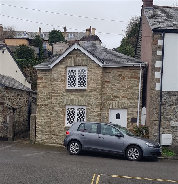
The Toll House is a Grade II listed building and is clearly detached from neighbouring houses and has a rather unusual architectural style that gives clues to its original use.
As this bridge is the lowest vehicle crossing of the River Fowey and is overlooked by Restormal Castle, its strategic importance dates back many centuries.
The house is a private residence - please respect the property and do not trespass. All the information you require can be obtained without crossing any property boundaries.
At the headline coordinates, please find the following information:
- What is the house number of the Toll House = A
Now examine the plaque on the close-by Boer War Memorial
- In what year was the monument erected =1BCD
- How many men are named as having returned safely from the War = E
- Number of letters in the first name of the first man mentioned = F
- Number of letters in the first name of the second man mentioned = G
Checksum: A+B+C+D+E+F+G=30
The cache can be found at N 50 24.(F-E)GC W 004 39.(G-A)B(D-A)
and is a modest stroll or a short drive away because of the proximity of other caches.
You can verify your answers and get a hint for the final location HERE

All active UK Toll House caches can be found here.
If other geocachers would like to set caches near UK Toll Houses, please get in touch with The Chens first and they will issue a number in the same way as the Church Micro series. They ask that the name is in the form "UK Toll House number - Local name". If you have a system of numbering your own caches, as they do, please put that last.