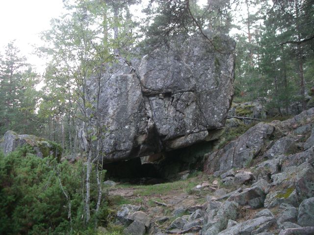
Blockgrotta/ Talus cave
I samband med att berg bildades i Centraleuropa för 250 miljoner
år sedan uppstod sprickor i jordskorpan. Längs dessa sprickor
försköts marken i höjdled och bildade ett naturligt
”trappsteg”. På detta sätt kom Kilsbergen att höja sig
över Närkeslätten. En spricka av detta slag kallas förkastning.
Från Närkeslätten framstår Kilsbergsförkastningen mycket
tydligt, och har gett upphov till namnet De blå bergen. I
väster finns ingen motsvarande förkastning, utan övergår omärkligt
i de värmländska skogshöjderna.
Här vid Falkaberget i Rosendal finns ett antal grottor som
bildades när inlandsisen drog sig tillbaka för ca 10 000 år
sedan. Det är sprickgrottor som uppkommit genom sättningar och
förskjutningar i berget, men också blockgrottor som uppstått när
flyttblock parkerats i terrängen av den smältande isen.
För att hitta denna geocache ska du besöka några av grottorna,
och sprickbildningarna i området. Du ska med hjälp av ficklampa
söka efter reflexbrickor som sitter fastsatta i berget inne i
grottorna. Anteckna det tal du ser på brickan. Ta inte loss
brickan.
Använd stignätet för att ta dig till ledtrådarna och slutgömman.
Tänk på att inte klättra, eller gå för nära stupen utan
säkerhetsutrustning. Fågelvägen är oftast inte bästa vägen!
- Steg 1: N59° 24.489 E015° 05.276,
Blockgrotta, A =
- Steg 2: N59° 24.481 E015° 05.242,
Blockgrotta, B =
- Steg 3: N59° 24.482 E015° 05.200,
Blockgrotta, C =
- Steg 4: N59° 24.642 E015° 05.437,
Vargaklämman, D =
- Steg 5: N59° 24.(A + B) E015°
05.(C + D)
Glöm inte ficklampan. Trevlig caching!
When mountains were formed in Central Europe for 250 million
years ago, there were cracks in the crust. Along these cracks the
ground shifted in height and formed a natural "steps". In this way
came Kilsbergen to rise above the plain of Närke. A crack of this
kind is called fault.
From the plain of Närke Kilsbergen fault seems very clear, and
has given rise to the name The Blue Mountains. In the west there is
no corresponding fault, but passes unnoticed in the forest hills
and mountains of Värmland.
Here at Falkaberget in Rosendal are a number of caves that were
formed when the ice sheet shrank away from about 10 000 years ago.
It is fracture caves caused by subsidence and displacements in the
rock, but also talus caves that occurred when boulders were parked
in the terrain of the melting ice.
In order to find the geocache, you should visit some of the
caves, and cracks in the region. By using your flashlight you will
find reflective tiles that are fixed in the rock inside the caves.
Enter the numbers you see in the washer. Do not remove the
tile.
Use the network path to get to the clues and the final cache. Be
careful not to climb, or go near the cliffs without safety
equipment. As the crow flies is usually not the best way!
- Step 1: N59° 24.489 E015° 05.276,
Talus cave, A =
- Step 2: N59° 24.481 E015° 05.242,
Talus Cave, B =
- Step 3: N59° 24.482 E015° 05.200,
Talus cave, C =
- Step 4: N59° 24.642 E015° 05.437,
Vargaklämman, D =
- Step 5: N59° 24.(A + B) E015°
05.(C + D)
Don't forget your flashlight. Happy caching!