The Las Vegas Valley fault system(LVFS) is composed of several
sub
parallel sets of faults including the Eglington, Decatur,
Valley
View, Cashman Field, Whitney Mesa, and West Charleston faults.
The
origin and earthquake potential of late Quaternary scarps of
the
Las Vegas Valley Fault system remains enigmatic. With the
exception
of the West Charleston Fault, which has an offset of only a
few
feet, the other six have displaced the surface from between 40
feet
and 125 feet during the past few hundred thousand years,
according
to “Slemmons”.
The Eglington fault is one of the
main
fault lines that runs across the Las Vegas Valley Floor. It
creeps
more than most faults in the valley each year. Possibly
increased
by ground water pumping. This fault has a few main areas it
runs.
For the most part it starts just North of the 215
between Losee and
Aliante , near the end of Clayton. Crisscrossing its way
south
passing near or under : Tropical and
Simmons, to Ann and Decatur,
to Lone Mountain and Camino Del Oro. Here
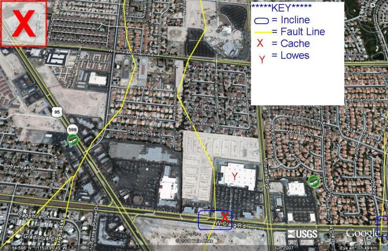
it splits in multiple
segments. First : passing Criag at Camino Del Oro (which there is a
major incline on Craig you can see driving down the road at
this
point). Second : passes Craig Under the Lowe’s just west of Jones
(which you can also see another slight elevation change here
on
Craig Rd). Third : crossing Lone Mountain following parallel to
Torrey Pines, then crossing Rancho and Craig again.
Fourth :
Passing directly under the Santa Fe
Casino, than running parrelle
just east of the 95 crossing close to the Craig Rd overpass
and
continuing on the east side of the freeway stopping just
before
Alexander. These descriptions are just what is shown as the
fault
lines on the USGS/Google earth maps. There are many fault
segments
that are unknown, unmapped or a listed as slightly off. These
main
faults are thought to produce a quake as large as a 6.5. The
background faults and unknown segments (that produced the 2.7
quake
in Summerlin are said to produce quakes as big as a 6.0 and
the
Frenchman mountain fault being a healty single 20miles long
fault
is thought to produce up to a 7.0. Its seen quakes in the far
past
that produced a 6 foot fault scarp and is thought to rupture
a
6.0-7.0 every 10,000 to 50,000 years.
All these fault caches I do are just meant to educate you.
Most
earth sciences to me are exciting and these just seem to go
along
with geocaching to me.
----------
---------


****Other Epicenter and
Fault Line Caches I have****
Epicenter "Summerlin" - GC10CPK
Epicenter "Amargosa Valley" - GC126ZC
EPicenter "Scotty's Jct." - GCZ03G
Epicenter "Wells" - GC1A7YV
"California Wash Fault" at HWY 169 - GC1MFF7
"Eglington Fault" - GC1PRKW
"Detrital Valley Fault" - GC201KR
Hawthorne Earthquake Swarm - April 2011 (HWY 359)
MORE TO COME SOON!!!!!!!!!!!!!

Current Quakes in area (if any)
