Throughout history we have had a fascination with water in all
its forms, from icebergs and snowflakes to lakes, rivers and
oceans. We have created paintings, written poetry and sung songs
celebrating it. We have had a special appreciation of waterfalls
and falling water. It could be its natural artistry or it could
spring more simply from its awesome display of raw power.
This earthcache will bring you to a waterfall that is not far
off of the beaten path, but which has that artistry and power.
Brief History of the Geology of the White Mountains (a part
of the Appalachian chain)
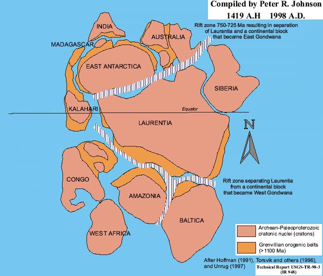
The Appalachians are a complex mix of mountains formed by a
series of continental collisions that took place over a period of
more than one billion years. Creation of the Appalachians began
more than one billion years ago when an extensive chain of
mountains was formed as a result of a series of collisions between
the largest land masses of the time. Approximately 85% of the
world's current land mass had formed by this time in the Earth's
history; however, the various pieces were arranged quite
differently than they are now (see sketches below).
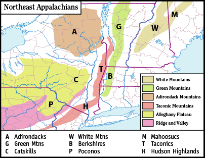
The White Mountains are a physiographic (the study of physical
features of the earth's surface) section of the larger New England
province, which in turn is part of the larger Appalachian
physiographic division. The magma intrusions forming the White
Mountains today were created 124 to 100 million years ago as the
North American Plate moved westward over the New England hotspot.
For an extensive geological history of the Appalachian Mountains
visit: link
The (Relatively) Recent Past: Glaciations and Rising Seas
Reshape the Coast
The most recent changes to the Appalachian mountains, and all of
New England, have been driven by erosion and glaciations, rather
than by the deformation of the earth’s crust. From about 1.8
million to about 11,000 years ago, a period known as the
Pleistocene, much of the northern portion of the world was
alternately covered with glacial ice and uncovered again during
interglacial periods. The last two glaciations reached the New
England coasts about 55,000 and 18,000 years ago. Everything was
covered, with slowly moving ice; even the tops of tall mountains.
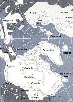
The map below depicts the maximum reach of the last great
glaciation, about 18,000 years ago. As the ice sheets advanced they
scoured rocks, uncovered Grenville formations and carved out
Narragansett Bay. Plants and animals were driven far south. As the
ice retreated it left debris - sometimes isolated rocks and
sometimes huge accumulations of rock, sand and silt. Many well
known geographical landmarks like Long Island, Long Island Sound,
Block Island, Nantucket and Cape Cod were created by glacial
action. Widespread evidence of glaciation may be seen in the
U-shaped form of various notches, or mountain passes. Glacial
cirques form the heads of Tuckerman Ravine on Mt. Washington and
King Ravine on Mt. Adams. Glacial striations are visible at
numerous locations, including on the exposed rocks at the summit of
Pine Mountain in Gorham.
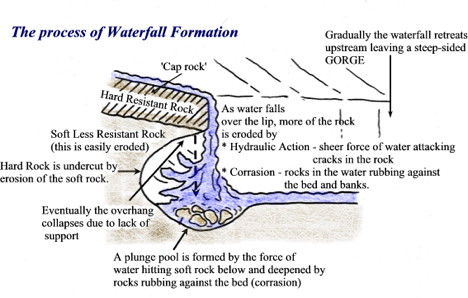
Formation of waterfalls
1.Waterfalls are found in the upper course of a river. They
usually occur where a band of hard rock lies next to soft rock.
They may often start as rapids.
2. As the river passes over the hard rock, the soft rock below
is eroded (worn away) more quickly than the hard rock leaving the
hard rock elevated above the stream bed below.
3. The 'step' in the river bed continues to develop as the river
flows over the hard rock step (Cap Rock) as a vertical drop.
4. The drop gets steeper as the river erodes the soft rock
beneath by processes such as abrasion and hydraulic action. A
plunge pool forms at the base of the waterfall.
5. This erosion gradually undercuts the hard rock and the plunge
pool gets bigger due to further hydraulic action and
abrasion.Eventually the hard cap rock is unsupported and collapses.
The rocks that fall into the plunge pool will continue to enlarge
it by abrasion as they are swirled around. A steep sided valley
known as a gorge is left behind and as the process continues the
waterfall gradually retreats upstream.
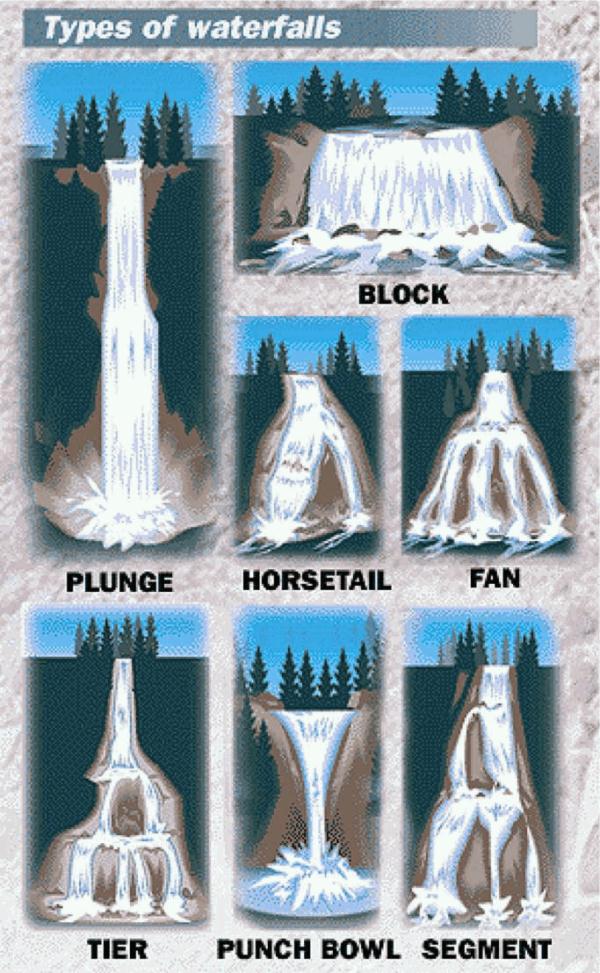
Types of waterfalls
The waterfalls of the world can be classified based on the
geometrical formation and various sizes and shapes. In common they
are classified into following types
Block: Block is a type of waterfall it occurs over a wide breath
of the stream. The waterfall must be wider than it is tall. A
waterfall with this form does not have to be a solid sheet of water
across it's entire width.
Cascade: In this type of waterfall form descends over, gradually
sloping rocks, a series of small steps in quick succession, or a
rugged sloping surface of some kind. Cascades can be both gradual
and steep.
Cataract: Cataract is a very powerful or high waterfall usually
occurring on a river
Fan: Waterfall of a Fan form occur when the breath of the water
in the waterfall increases during it's decent, causing the base of
the falls to appear much wider than the top of the falls. ( A
narrow waterfall spreads out like a fan at the bottom.
Horsetail: Horsetail waterfall are characterized by the constant
or semi-constant contact the water keeps with the bedrock as it
falls. Horsetail waterfalls can be almost vertical, as well as very
gradual.
Plunge: (Clinched Waterfall) : In this type of waterfall the
water drops vertically, losing most, or all contact with the rock
face.
Punchbowl: The term coined from the famous Punch Bowl falls in
Oregon, it occurs where the stream is constricted to a narrow
breadth and is forcefully shot outward and downward into a large
pool.
Segmented: In this type of waterfall formed by the descending
watercourse splitting up into two or more parallel segments or
threads.
Tiered: Tiered waterfall are characterized by multiple distinct
drops in relatively close succession to one another. Whether or not
a waterfall with two visible drops counts as a tiered waterfall is
up to the beholder.
Multi-step: A series of waterfalls one after another of roughly
the same size each with its own sunken plunge pool.
References:
Wikipedia
Jamestown, RI website
St. Ivo School Geography Department
ODE TO A WATERFALL
by Bobbi Duffy
My heart sighs with pleasure as I look upon your grace.
How my soul has longed to find this holy place,
And watch your cascading flow give birth to healing rainbows;
God’s promises that wipe away all of life’s petty hurts
and woes,
And smell the fragrant flowers nourished by your loving mist
Blooming in the supple earth by your magic kissed.
To hear the thundering whisper of life’s quickening
essence
Come tumbling down from the heights to find its absolute
quintessence.
Would that I could laze my days within your life giving
bower,
And taste forever the delicate freshness of your purifying
power.
LOGGING
REQUIREMENTS
The cache coordinates will bring you to two different
observation platforms overlooking this waterfall. The answers to
the following questions can be found at one or the other of these
platforms.Email me the answers to the following questions as well
as posting with your log a picture of the Falls with your GPSr in
the picture:
Question #1: What is believed to have created this Falls?
Question #2: What is the height of these Falls on the sign?
Question #3: How many gallons of water pass over the Falls every
few seconds?