A River Basin is an area of land which drains via a river that is fed with numerous tributaries. The land it encompasses is dissected and drained by a plethora of streams and creeks that flow to lower elevations into one another into a major river and eventually into a confluence with another main river or finally the ocean or sea.
San Antonio River Basin is a moderate sized river basin in Texas. Texas has approximately 191,000 miles of streams, 15 major river basins, eight coastal basins, and 196 major reservoirs.
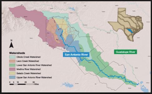
Within the SARB ( San Antonio River Basin) there are 6 watershed designated areas.
- Atascosa River Watershed starts at 232 ft elevation
- Cibolo Creek Watershed starts at 1673 ft elevation
- Leon Creek Watershed starts at 1027 ft elevation
- Medina River Watershed starts at 1745 ft elevation
- Salado Creek Watershed starts at 1296 ft elevation
- Upper San Antonio River Watershed starts at 1692 ft elevation
- San Antonio River meets the Gaudelupe River in Refugio County 28.506996, -96.891030 3 ft elevation
All of them except the Atascosa Drain to the San Antonio River. A watershed is an area that drains to river or stream. Everyone lives in a watershed. If you don’t know which watershed you live in maybe do al little research. Maybe mention which watershed you generally cache in within your log. (Not a requirement of logging this earth cache) If you do share you will be mentioning 1 of over 200 watersheds in the USA.
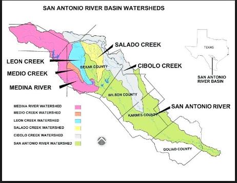
The San Antonio River originates in the middle of San Antonio from several springs near down town. It flows in an easterly south direction where it meets the Guadalupe River about 10 miles from San Antonio Bay On the Gulf of Mexico. It is 240 miles long and the Watersheds listed in this description except the Atascosa feed this River within the SARB.
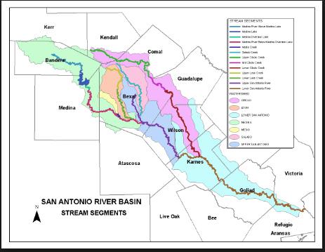
As you view the stream segment diagram which stream segment is the 2nd largest within the SARB? Which direction is this stream from where you are standing at ground zero?
Take a walk down towards the river trail to make your observations make your calculations and notes.
How many counties does this Basin touch all the way from the headwaters to the coast.
What is your elevation reading at the coordinates that you are standing? What is the difference between this elevation where you are and the Uppermost stream contribution to the San Antonio River Basin tell me which one you are choosing? The difference between where you are and where it enters the gulf?
What percent of the SARB(San Antonio River Basin) by your estimation is upstream from you at these coordinates? And your estimation percent of what is downstream?
Not a requirement of earning credit for this earth cache but it would be great if you could share a photo or 2 in your log of the area.
And Just for fun there is a sculpture of the SARB on the wall of the building….. see if you can identify the contributing watershed streams that flow to the San Antonio River within the Basin.
Remember that I'm not trying to judge people for getting the answers exact. I'm more interested in knowing people are going out to the location and engaging with the concepts involved. Don't worry about being 'wrong' - use what you know and make a solid effort. Earth caches are supposed to be fun. Please send me your answers via message or email.
Thank you for visiting this earth cache!! And always make sure to plan according to the climate and weather conditions when geocaching.

CONGRATULATIONS TO ANTEAUS ON FTF!!!
