As this is an EarthCache, there is NO container. To claim this as a find you will need to complete the tasks outlined below. Failure to complete the tasks may result in the deletion of your log without notice. Exceptions will be considered if you CONTACT ME FIRST (I realize sometimes we forget our cameras or the batteries die).
There is a fee to enter this state park. You may buy a daily or yearly pass at the ranger station or at the parking area located at N43 19.117 W088 18.513. At either location you can find a trail map or you may download one HERE. Park hours are 7am to 8pm. After parking you will need to walk along the road until you reach either of the two trailheads which will lead you to the tower. From the trailhead you will follow a hilly well groomed trail to the tower.You should expect to walk about 1 mile round trip.
Winter Information: When the trails are groomed for cross country skiing, hiking is not allowed on them. During times of snow please enter the trail system at N43 18.881 W88 18.582 (directly across the road from the campground entrance). This trail is not groomed and hiking is allowed.
For this EarthCache you will be visiting the Pike Lake Unit of the Kettle Moraine State Forest. The Kettle Moraine is a strip of glacial landforms which extends through southeastern Wisconsin to Lake Winnebago. It is made up of numerous kames, kettles, and eskers which were created as glaciers advanced and retreated in the region some 14,000 to 15,000 years ago.
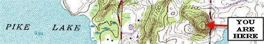
The coordinates for this EarthCache will bring you to a tower on Powder Hill. This tower looms over 300 feet higher than Pike Lake. Powder Hill is a kame which is a hill or mound composed of sorted or stratified sand and gravel that is deposited in contact with the glacial ice. Normally these kames have an irregular shape. As you can see from the small section of topographic map above this kame towers over the surrounding area even without the addition of a man made structure.
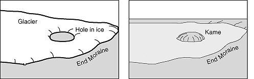
As you can see in the picture below a kame can be formed when a hole in a retreating glacier is created and then subsequently filled with runoff materials from the glaciers melt. As more materials are flushed into the hole, the kame grows larger. Eventually the glacier will retreat further or melt altogether leaving the piled up earth as a large hill or what is known as a kame.
The tower overlooks Pike Lake. This 446-acre lake is actually a spring-fed kettle. A kettle is basically the opposite of a kame. When a block of glacial ice is stranded by a retreating glacier, it prevents sediments from being deposited. When the chunk of stranded ice finally melts, a depression is left that fills with water.
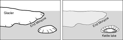
In the picture below you can see an example of a kettle lake formation. Here a piece of ice has been left behind as the glacier continues to cut along the surface depositing sediments as it goes. As the ice is left in a depression the deposits fill around and on top of it but once the smaller isolated piece melts, a hole is formed. This hole often fills with water and a pond or lake is formed.
* To claim this EarthCache you will need to complete the following three tasks *
(FOR # 2 AND # 3 DO NOT ANSWER THESE QUESTIONS IN YOUR LOG. E-MAIL THEM TO ME.)
1. Upload with your “found it log” a photograph taken from the top of the tower (including your GPS).
2. E-Mail me: From the base of the tower approximately how much higher is it to the top of the kame.
3. E-Mail me: From the signs on the tower, what are the 1st and 2nd highest points in southeastern Wisconsin?
The Geocache Notification Form has been submitted to P Joseph K. Fieweger: Lead Law Enforcement Ranger Kettle Moraine State Forest - Pike Lake and Loew Lake Units. Geocaches placed on Wisconsin Department of Natural Resource managed lands require permission by means of a notification form. Please print out a paper copy of the notification form, fill in all required information, then submit it to the land manager. The DNR Notification form can be obtained HERE.
The Boardwalk Trail. A wheelchair accessible boardwalk runs through a wetlands area along Pike Lake.
The Black Forest Nature Trail. This is a short walk through a forest of old-growth trees.
The Ice Age trail. Like many parts of the state the Ice Age trail runs through the park.
Astronomy Trail. This trail provides a sense of the scale of the solar system, route markers for each planet are placed at the approximate distance from each other corresponding to the distance between planets.
Wisconsin's oldest active Geocache. Pike Powder Hike is located only a stone's throw from the tower.
References:
http://www.stateparks.com/pike_lake.html
http://dnr.wi.gov/org/land/parks/specific/pikelake/
I have used sources available to me by using google search to get information for this EarthCache. I am by no means a geologist. I use books, internet, and ask questions about geology just like 99.9 percent of the geocachers who create these great EarthCaches.