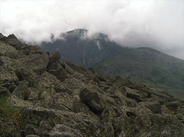
When you arrive at the upper slopes of the presidential range above treeline, among the most impressive features are the massive rock piles that make up the summits, and the vast boulder fields covering the alpine plateaus. As you scramble up and over rock piled upon jagged rock in a chaotic jumble of large and small boulders, have you ever wondered how these large blocks got here, and how they got piled up on top of each other?
Unlike the talus we see elsewhere in the White Mountains, where eroded rock tumbles down mountain slopes, there is nowhere higher for these rocks to come from. Given how much of New Hampshire surface geology resulted from the action of glaciers, it is tempting to think that these were carried by the ice sheets and dumped as glacial moraine. But that is not the case. The felsenmeer was created after the end of the ice age. Felsenmeers are actually formed in situ, meaning that they were not transported during or after their creation.
This felsenmeer is part of an extensive ‘sea’ beginning at 5,000 feet that wraps around the Jefferson summit.
Frost plays a pivotal role in the formation of felsenmeer: first by wedging apart and then fracturing jointed bedrock into large blocks and, second, by heaving the blocks upwards from the bedrock several feet until they rest on the surface or on top of each other in vast boulder fields.
Frost wedging occurs when water that is trapped along microcracks in the rock expands and contracts due to fluctuations in temperature above and below the freezing point. Everyone who has used an ice tray knows that water expands when it freezes (about 9% increase in volume). What may not be apparent is that process generates tremendous force. As the water freezes and expands, it can exert a force of 22,000 pounds per square inch; easily enough to fracture the metamorphic schists of the Littleton Formation that comprise the bedrock of the Presidential Range.
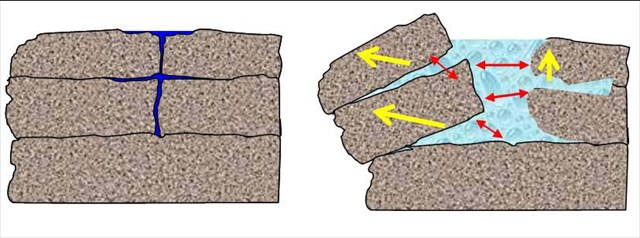
Step 1. Frost wedging separates blocks from the bedrock
Frost heaving also occurs due to the pressure generated by the expansion of freezing water. Although the force generated by freezing water is exerted in all directions; with bedrock below, only upwards and horizontal movement can occur. Blocks that are first separated from the bedrock by frost wedging are then heaved above the surface resulting in the random heaps characteristic of felsenmeer.
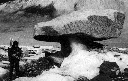
Step 2. Frost heaving lifts up the blocks into piles (Note, this was not taken in New Hampshire but illustrates the extent that ice can lift a boulder)
Logging Requirements:
Please send me an email with your answers to the following questions:
1. Please describe what you see with sufficient detail to demonstrate that you made the hike up here.
2. In addition to the lichen covered darker rocks that predominate, there are large white boulders of quartz that are frequently seen placed in cairns. From what you have learned, please describe how you think they got here. If you are having trouble, examine the occasional quartz that you encounter along the trail for clues.
Optional: Weather permitting, enjoy the view.
Sources: http://whitemountainsojourn.blogspot.com/2010/11/11-06-10-mt-jefferson-glacial-geology.html
http://www.nhdfl.org/about-forests-and-lands/bureaus/natural-heritage-bureau/photo-index/felsenmeer.aspx