Version francais
au-dessous
English version
below
Dieser Earthcache soll euch die Besonderheiten einer ehemaligen
Bleimine zeigen und wie die Natur sich ihr Eigentum wieder zurück
genommen hat und darin ihre Schönheiten zeigt
Der Name des Ortes Plombières leitet sich ab vom französischen
Wort "plomb" für Blei. Seit dem 14. Jahrhundert wurde in der Region
um Plombières, Montzen, Hombourg, Mechernich und Gemmenich Bleierz
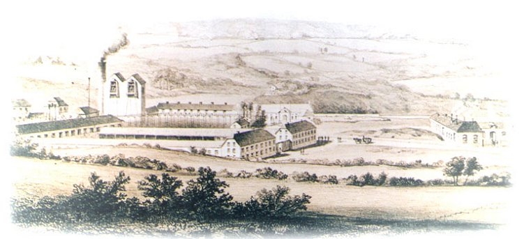
abgebaut. Der Ort Plombières veränderte sich in alter Zeit von
einem eher unbedeutenden kleinen Weiler in eine Stätte lebhafter
Industrie. Der Erzabbau und die Verhüttung fanden hier im Dreieck
zwischen den heutigen Nationalstrassen N608 und N613 statt. Das
Gelände des ehemaligen Bergwerks liegt im Tal des Flüsschens
Gueule, welches sich ein Bett durch die verschiedenen Faltungen und
Überschiebungen des Grundgebirges gegraben hat.
Die teilweise in SW- und teilweise in NO-Richtung verlaufenden
Erdschichten bestehen aus Sandstein und Schiefer aus der
Famennestufe des Oberdevon sowie Kalkstein- und Dolomitschichten
des Unterkarbon. In den quer zu diesen Schichtungen verlaufenden
Störungen der Erdstruktur findet man zum Teil ertragreiche
Erzlagerstätten. Diese werden unterschieden in Sulfid- und
Nichtsufidverbindungen.

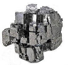
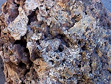
Die tiefer liegenden Schichten davon führen die
Metall-Sulfid-Verbindungen wie Zinkblende, Bleiglanz, Eisenkies und
Schwefelkies. Zinkkarbonat, Zinksilikat, Limonit und Weissbleierz
sind eine aus den vorgenannten Erzen unter Luft- und
Wassereinwirkung entstandene Mischung namens Galmei, welches als
sogenannter "Eiserner Hut" in den oberen Schichten vorkommt.

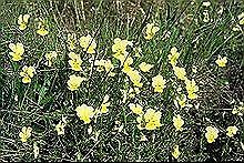
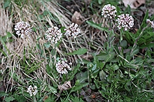
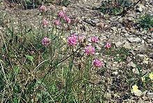
Die erzhaltigen Böden bringen einen besonderen Pflanzenreichtum
hervor. Nur auf diesen Böden gedeien das gelbe Galmeiveilchen, das
weisse Galmeitäschel und die violette Grasnelke.
Das kleine Flüsschen Gueule bereitete dem Bergbau große
Probleme. Durch die Kessellage und das darin verlaufende Flüsschen
kam es immer wieder zu Wassereinbrüchen und Überflutungen der
Bergbaustollen. 1861 erhielt die damalige Bergbaugesellschaft die
Erlaubnis, die Gueule zu kanalisieren. Dies führte zu einer der
besonderen Sehenswürdigkeiten dieses Geländes. Die Gueule wurde an
einer Stelle durch einen künstlichen Felsdurchbruch aus dem Kessel
des Bergbaugebietes raus geleitet.

Zwar war dadurch eine Gefahr gebannt aber der in neuerer Zeit
immer unrentablere Bleigewinn führte in den 1920er Jahren zur
Aufgabe der Minen in Plombières. Die Gebäude zerfielen und die
Schächte wurden verfüllt.
Heute ist das Gelände zum Teil renaturiert und ein Refugium für
Menschen, Tiere und Pflanzen. Im nördlichen Bereich befindet sich
ein Park mit Grillhütte, in der Mitte ein noch wilder
ursprünglicher Bereich und im Süden ein eingezäunter
Naturschutzbereich.
Das ganze Gelände, auch der Naturschutzbereich, ist öffentlich
zugänglich. Naturfreunde werden eine Vielzahl von Pflanzen finden,
die speziell auf bleihaltigen Böden wachsen. An vielen Stellen sind
kleine Informationschilder aufgestellt, die die Pflanzen benennen.
Auch ohne Geocaching ist dieses Gelände einen Besuch wert und
bietet reichlich Fotomotive. Also Fotoapparat nicht vergessen!
Die nachfolgend beschriebe Erkundungstour durch das Gelände
führt zu den interessanten Punkten des ehemaligen Minengeländes. An
vier Stellen werden Fragen gestellt, die für Logfreigabe dieses
Earthcaches beantwortet werden müssen.
Parken kann man gut etwas ausserhalb des Geländes bei
N50 44.270 E5 57.630. Hier findet ihr eine Tafel mit
Informationen zur Region und zum alten Minengelände. Nahe der
schönen Kirche mit oktonalem Hauptraum steht ein Gedenkobjekt für
die Bergarbeiter. Beantwortet hier bitte die
Frage 1: In welchem Jahr wurde die Société gegründet?
Jetzt geht's zum Minengelände. Quert dafür die Straße in
Richtung Süd-Ost, zweigt in die kleine Straße ab und folgt dem
Schild "Plombières, Le Site Calaminaire et son Parc" Folgt dem Weg
geradeaus bis N50° 44.074 E005° 57.904, biegt dann nach
links ab und folgt dem Weg bis zur Brücke über die Gueule bei
N50° 44.163 E005° 58.026
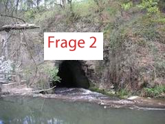
Hier seht ihr den künstlichen Fels-Durchbruch, durch den die
Gueule aus dem Minengelände geleitet wurde und dadurch ein
Wassereinbruch in die Stollen vermieden wurde. Hier sieht man auch
gut den Verlauf der geologischen Schichtung. Hierzu die
Frage 2: Wie verläuft die geologische Schichtung direkt
oberhalb des Durchbruchs (fast horizontal oder eher
schräg)?
Wenn ihr möchtet, könnt ihr den Weg nach oben folgen, die
Strasse queren und euch die andere Seite des Durchbruchs bei
N50° 44.233 E005° 58.032 ansehen. Danach bitte wieder zurück
zur Brücke.
Zurück an der Brücke folgt dem Weg der Gueule entlang des
östlichen Ufers nach Süden bis ihr am kleinen Tor bei N50°
44.091 E005° 58.113 das besondere Naturschutzgebiet betreten
könnt (bitte das Tor wieder schliessen).
Das Betreten des Schutzgebietes ist erlaubt. Hier genießen
Pflanzen und Tiere besonderen Schutz. Bitte beachtet dies und
verhaltet euch entsprechend. Schaut euch hier die Vielfalt der
Pflanzen an, die trotz oder gerade wegen des erzhaltigen Boden sehr
gut gedeien.
Genießt es auf den Sitzbänken die Natur zu beobachten. Folgt
dann dem schmalen Pfad bis auf den Hügel. Von hier habt ihr einen
wunderbaren Blick auf das Gelände. Der Boden zeigt euch deutliche
Spuren des ehemaligen Erzabbaus und der Verarbeitung. Hier findet
ihr viele Schlackenreste aus den alten Schmelzöfen. Vielleicht auch
einige Mineralien.

Verlasst das Schutzgebiet wieder bei N50° 44.011 E005°
58.203 durch das kleine Tor und folgt dem Weg bis zu N50°
43.998 E005° 58.104 Ein Kreuz errinnert hier an die
Vergänglichkeit des Lebens. Beantwortet bitte die
Frage 3: Wie hieß Clement mit Nachnamen?
Folgt weiter dem Weg über eine Brücke bei N50° 44.032 E005°
58.090 und über die alte Minenstrasse und findet bei N50°
44.090 E005° 57.984 Markierungen zweier ehemaliger Schächte der
Minenanlage. Die Markierungen tragen den Namen der Mine. Damit
beantwortet bitte die letzte
Frage 4: Wie lautet der Name der Mine auf den Markierungen
("Mine de ….")?
Damit ist die Erkundungstour durch das alte Minengelände
beendet. Ich würde mich freuen, wenn es euch gefallen hat. Bitte
schickt mir die Antworten auf die 4 Fragen per Email über meine
Profilseite. Ein Foto von eurem Besuch würde mich freuen, ist aber
freiwillig und keine Logbedingung. Danke!
Version
francais>
Cet earthcache doit vous montrer les
particularités d'une ancienne mine de plomb et comme la nature pris
retour sa propriété et montre sa beauté.
Le nom de la petite ville Plombières est
derivé du mot "plomb". Depuis le 14iême ciècle on extrait du
colombin de la region de Plombières, Montzen, Hombourg, Mechernich
et Gemmenich. Plombières c'est développé d’un simple hameaux
à un lieu industriel vivant à l'époque. L'exploitation du minerai
et le traitement sont arrivés dans le triangle entre les routes
nationales N608 et N613. Cela le terrain de l'ancienne mine se
trouve dans la vallée de la rivière de la Gueule s'est creusé qu'un
lit par les différents plissements et tractions du
sous-sol.
Les couches de terre qui s’étendre
en direction sud-ouest et nord-est sont composé en partie du grès
et de l'ardoise du famenne de Dévonien Supérieur ainsi que de
dolomite et de calcaire du Dévonien Inférieur. Dans les
dérangements de la structure de terre qui se passant en travers à
ces stratifications, on trouve des gisements minéraux en partie
lucratifs. Ceux-ci sont différenciés dans les nonsulfides et les
sulfides.
Dans les couches plus profondément on
trouve des composés de sulfure et métal comme la blende, la galène,
le gravier en fer et le gravier de soufre. Carbonate de zinc,
silicate de zinc, limonit et minerai de plomb de blanc sont les
mêmes minerais après d’influence d’air et d’eau
qui forment un mélange nommè Galmei. Ca on trouve dans les
stratifies supérieurs, nommé le „Eisenhut“ (chapeau en
fer).
Les sols ici apportent une richesse
végétale particulière. Seulement sur ces sols s'élèvent le
„Galmeiveilchen“ jaune, le „Galmeitäschel“
blanc et le „Grasnelke“ violet.
La petite rivière Geulle a causé de grands
problèmes à l'industrie minière. À la cause de la vallée encaissée
et la rivière se passant dans, on en est venu toujours à nouveau à
des effondrements d'eau dans les puits. En 1861 l'entreprise
minière de l'époque a reçu l'autorisation de canaliser la Gueule.
Cela a conduit à un curiosités particulières de ce terrain. La
Geulle etait dévié par une percée artificielle par le
rocher.
Ainsi que le danger d’effondrements
n’existe plus, le profit de plomb devenait récemment de plus
en plus non rentable, et les mines à Plombières ont été abandonnées
dans les années de 1920. Les bâtiments se sont désagrégés et ont a
remplis les puits.
Aujourd'hui, ce terrain est cultivé en
partie et est un refuge pour l'homme, les animeaux et les plantes.
Un parc avec une place pour fair le barbecue se trouve dans le
secteur au nord. Au milieu un secteur original encore sauvage et
dans le sud un secteur de protection de la nature
enfermé.
Le terrain entier, aussi le secteur de
protection de la nature, est accessible pour le public. Les amis de
la nature trouveront une multiplicité de plantes qui s'élèvent
spécialement à des sols contenant du plomb. Vous trouvez des petits
plaques avec les noms des plantes. Sans faire le geocaching aussi,
ce terrain vaut une visite et offre beaucoup de motifs de photo. Ne
pas oublier ainsi l'appareil photographique!
Le tour d'exploration par le terrain
décrirait par la suite vous conduit aux points intéressants de
l'ancien terrain de mine. Quatre questions sont posées q’on
doit répondre pour gagner permission pour un log de cet
earthcache.
Stationner la voiture est possible à
N50° 44.270 E005° 57.630. Ici vous trouvez aussi des
informations sur la region et la mine ancienne. Près de la belle
église avec un interieur octogonal il y a un object pour souvenir
les mineurs. Répondez s.v.p. la
question 1: Dans quel an la Société
etait constitué?
Maintenant pour le terrain de la mine:
Traversez la route vers sud-est, prenez la petite route et
continuez à l’indication "Plombières, Le Site Calaminaire et
son Parc" jusqu’au N50° 44.074 E005° 57.904. Ici
tournez à gauche et suivez le chemin jusqu'au pont sur la Geulle à
N50° 44.163 E005° 58.026
Ici, vous voyez la percée artificielle par
le rocher, par laquelle la Gueule a été conduit et alors un
effondrement d'eau dans les puits a été évité. Ici, vous voyez
aussi bien le cours de la stratification géologique. S.v.p.
rèpondez la
question 2: Comme la stratification
géologique se passe directement au-dessus de la percée, presque
horizontalement ou plutôt en biais?
Si vous voulez, vous pouvez suivre vers le
haut le chemin, traverser la route et voir l'autre côté de la
percée à N50° 44.233 E005° 58.032. Après retournez ici
s.v.p.
Encore au pont, suivez vers le sud long de
la Gueule à la rive d’est jusqu’au entré de la réserve
naturelle à N50° 44.091 E005° 58.113 L’accèss à la
réserve naturelle est autorisé. Fermez la porte après
s.v.p.
Ici les plantes et les animeaux sont
protégées. Respectez-les! Prenez place sur un banc et savourez la
nature. Après continuez le sentier sur la collune. Vous avez un
voir merveilleux sur le terrain. Sur la collune on trouve des
scories des fours à cuir et peutêtre aussi des
minereaux.
On quitte la réserve naturelle par une porte à N50° 44.011 E005°
58.203 (fermez la après s.v.p.). À N50° 43.998 E005°
58.104 une croix nous rappele aux caractère éphémère de la vie.
Répondez ici la
question 3: Quel est le nom du famille
du Clement?
Suivez le chemin par un pont à N50°
44.032 E005° 58.090 et sur l’ancienne route des mineur
jusqu'aux le lieu où les deux puits etaient situés à N50° 44.090
E005° 57.984 Les deux carreau en béton montrent le nom des
puits. Rèpondez s.v.p. la dernière
question 4: Comme est le nom du mines
montrè ici ("Mine de ….")?
Ici le tour d'exploration par le vieux
terrain de la mine est terminé. Je me réjouirais, s'il vous a
satisfait. Envoie moi les réponses aux 4 questions par l'émail pour
gagnez la permission d’un log. Une photo de votre visite
réjouirait moi, mais est toutefois volontaire et pas un condition
pour un log. Merci!
English
version
This Earthcache is to show you the
characteristics of a former lead mine and how nature took back her
properties again and presents her beauty
The name Plombières is derived from the
French word "plomb" for lead. Since the 14th century people digged
for lead ore in the regions around Plombières, Montzen, Hombourg,
Mechernich and Gemmenich. The place Plombières changed from a
rather insignificant small village into a place of lively industry
in former times. Digging for ore and melting took place here in the
triangle between the today's national routes N608 and N613. That
Area of the former mine lies in the valley of the river Gueule,
which dug itself a bed through the different geological foldings
and earth-layers.
The partially to SW and partly to NO
directions stretching earth layers consist of sandstone and slate
of the Famenne of the Upper Devonian as well as limestone and
dolomite layers of the Lower Carboniferous. In the disturbances of
the earth structure running transverse to these layerings one finds
partially productive ore stores. These distinct into sulfides and
nonsulfides.
The more deeply lying layers of it contain
those metal-sulfides such as zinc blende, galena, iron pyrite and
sulfur gravel. Zinc carbonate, zinc silicate, limonit and other
lead ores are similar ores that under the influence of air and
water developed a mixture named Galmei, which as socalled
„Eiserner Hut“ (iron hat) can be found in the upper
layers.
The grounds containing these ores provide
the growing of special kinds of plants. Only on these grounds the
yellow „Galmeiveilchen“, the white
„Galmeitäsche“ and the violet „Grassnelke“
can be found. .
The small river Gueule was providing big
problems to the mining industry. Due to the site lying in a valley
and the river running therein water covers the area from time to
time and was floodings of the mining galleries. In 1861 the mining
company of that time gained permission for canalizing the Gueule.
This led to one of the special objects of interest of this area.
The Gueule was rerouted out the valley by an artificial rock
break-through.
Though the danger of flooding was avoided
however in more recent times the ever more unprofitable lead gain
was the reason for closing the mines in Plombières by the years of
1920. The buildings disintegrated and the pits were
refilled.
Today the area is partially re-natured and
now provides a preserve for humans, animals and plants. In the
northern range we find a park with a barbeque hut, in the center
still an area of wilderness and in the south an enclosed nature
protection area.
The whole area, also the nature protection
range, is public accessible. Nature friends will find a
multiplicity of plants, particularly those growing on lead
containing grounds. In many places you find small
informationstables, which name the plants.
Also without geocaching this area is worth
a visit and offers plentifully motives for photoshooting. Thus do
not forget your camera! The expedition tour described below leads
to the interesting points of the former mining area. Four questions
are asked, those are to be answered to gain a log
permission.
Parking is possible outside at
N50° 44.270 E005° 57.630. Here you also find some
informations about the region and the old mining facility. Close to
the nice church with has a octogonal shaped interior you find an
object that remembers the mine workers. Here, please
answer
question 1: In which year the
„Sociètè“ was founded?
Now to the mining area: Cross the street
in direction south-east, take the small road and follow the sign
„Plombières, Le Site Calaminaire et son Parc". Follow the way
straight on N50° 44.074 E005° 57.904, turn left and follow
to bridge at the Gueule at N50° 44.163 E005°
58.026.
Here can see to the artificial rock
break-through, by which the Gueule is led out of the mine area and
thus flooding the galleries was avoided. Here you also have good
look to the geological layering. Please answer
question 2: How is the geological
layering right above the break-through, quite horizontal or more
inclined?
If you like you can follow the path up to
the top and cross the street to find the other side of the
break-through at N50° 44.233 E005° 58.032. Afterwards please
return back the bridge.
Back again at the bridge take the path
following east-sided along the Gueule southwards until you reach a
small gate at N50° 44.091 E005° 58.113 leading into the
special public accessable nature preserve area (please close the
gate behind you).
In this area plants and animals are under
protection. Behave appropriate! Take a seat on the bench and enjoy
the nature. After that, follow the small path to the hill. From
here you have great overlooking view on the area. Right here you
find the scoria of the kilns and perhaps also some
minerals.
Leave the preserve area by the small gate
at N50° 44.011 E005° 58.203 (please close it again) and
follow to N50° 43.998 E005° 58.104. A cross remembers the
caducity of life and gives the answer to
question 3: What is the second name of
Clement?
Follow the path
across a bridge at N50° 44.032 E005° 58.090 and via the
former mining road and find the place at N50° 44.090 E005°
57.984 where two mining towers once existed. The concrete tells
you the name of the mine which is the answer to
question 4: What
is the name of the mine ("Mine de ….")?
Now you have come to
the end of this short expedition tour. I hope you enjoyed it.
Please send me your answers by email to gain log permission. A
photo of your visit is welcome but not necessary for logging.
Thanks!