©#3 Rocca Clarì - La Sommità Traditional Geocache
©#3 Rocca Clarì - La Sommità
-
Difficulty:
-

-
Terrain:
-

Size:  (micro)
Please note Use of geocaching.com services is subject to the terms and conditions
in our disclaimer.
Cache raggiungibile direttamente da Claviere o in alternativa al termine della della Via Ferrata della Rocca Clarì mentre rientri.
You may reach this cache either directlyfrom Claviere or alternatively after the Via Ferrata Rocca Clarì while getting back.
Diesen Cache kannst du entweder direkt von Claviere angehen oder alternativ am Ende der Via Ferrata der Rocca Clarì auf dem Rückweg.
BYOP
(©#3)
 « Rocca Clarì - La sommità» « Rocca Clarì - La sommità»
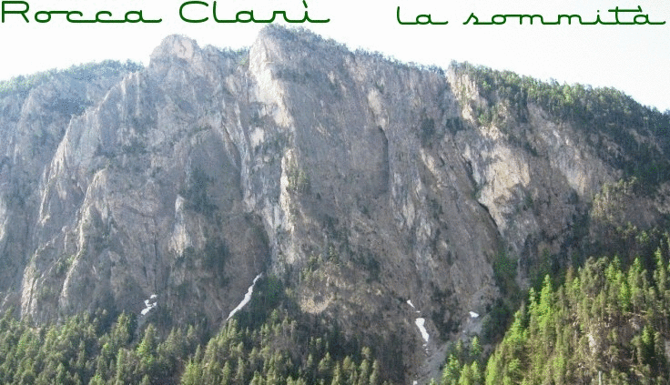
La Rocca Clarì (2051 m), pur non essendo una delle montagne conosciute ed importanti della valle, è senza dubbio una di quelle più sovente ammirate, in quanto il suo versante Nord-Ovest precipita in maniera imponente e selvaggia nella valletta della Piccola Dora, nelle sGorge di San Gervasio per essere precisi. Questo versante è pertanto ben visibile percorrendo la Strada Statale del Monginevro, tra Cesana T.se e Claviere. A causa della posizione strategica sul colle del Monginevro, vi sono molte strutture belliche abbandonate che facevano parte di una linea difensiva della seconda guerra mondiale.
Accesso: Tramite comoda passeggiata di ca 45 minuti partendo da Claviere e passando da località La Coche (destinazione degli impianti sciistici) con il suo lago artificiale.
Altrimenti al termine della Via Ferrata Rocca Clarì.
Buon divertimento!
 «Rocca Clarì - the summit» «Rocca Clarì - the summit»
The Rocca Clari (2051 m a.s.l.), although is not one of the well known and important mountains of the valley, is certainly one of those most often admired, as his side Nort-Western rockface falls down steep and impressively into the Piccola Dora's valley (Gorge of San Gervasio) and is therefore clearly visible while travelling on the Monginevro highway between Cesana Torinese and Claviere. Because of its strategic location on the Montgenevre-Pass, there are many abandoned military facilities that were part of a defensive line of World War II.
Access: With a comfortable walk of about 45 minutes starting from Claviere and moving passing by La Coche (destination of ski-lifts) and it's artificial lake.
Otherwise, right at the end of the Via Ferrata Rocca Clarì.
Have fun!
 «Rocca Clarì - der Gipfel» «Rocca Clarì - der Gipfel»
Die Rocca Clari (2051 m ü.d.M.) gilt gewiss nicht zu den bekannten und "wichtigen" Bergen des Tales, aber sie ist ohne Zweifel einer der am häufigsten bewunderten, da die Nord-West Felswand steil und imposant in das Tal der Piccola Dora (die Schlucht von San Gervasio, um genau zu sein) stürzt und daher deutlich sichtbar ist, wenn man auf der Bundestrasse von Monginevro zwischen Cesana Torinese und Claviere reist. Aufgrund der strategischen Lage Nahe des Montgenevre-Alpenpasses, gibt es hier einige verlassene militärische Anlagen, die Teil einer Verteidigungslinie des Zweiten Weltkriegs waren.
Zugang: Mit einem gemütlichen Spaziergang von etwa 45 Minuten ab Claviere über La Coche (Ziel der Ski-Lifte) mit seinem kleinen künstlichen See.
Ansonsten im Anschluss an die bzw. auf dem Rückweg von der Via Ferrata Rocca Clarì.
Viel Spaß!
 
|
Additional Hints
(Decrypt)
"fhcrecbegrf"
OLBC