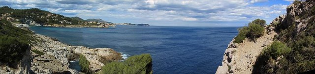
La historia de la isla abarca un período de 300 millones de años que van desde el Carbonífero, la edad del carbón, los desiertos de piedra arenisca roja y el estado de la mar del Mesozoico hasta los desiertos de sal terciarios e incluso más tarde la lluvia torrencial de la historia geológica reciente. El origen de la estructura morphotektonischen de la cadena de islas Baleares corresponde a un plan alpino. Las Islas Baleares son un fragmento de un sistema montañoso veces alpidic zirkummediterranen que proyecta un gran arco montañoso a partir de la Cordillera Bética, al sur de España, ampliamente utilizado en el Mediterráneo. Malloca tiene un triple orográfica, el paisaje es único y claramente visible en todos los viajes alrededor de la isla. Toda la parte occidental y noroccidental de Mallorca ocupa la cordillera principal, la Serra de Tramuntana. Es la única montaña de la isla, que bloquea la vista del mar, con su alto borde de más de 1000m. La Serra de Tramuntana aumenta el Puig Major, el pico más alto de Mallorca, hasta 1445m. Aquí las montañas de abruptos cañones, algunos cañones salvajes aparecen cortados. La contrapartida de esto es en el este de la Serra de Llevant. Una vez más, las montañas subida, pero sólo alcanzan una altura de 561m y que no están influenciados por la misma brusquedad hasta que caracterizan a la cordillera principal. Incrustado entre estas dos zonas montañosas o de colinas, las extensas llanuras veces ligeramente onduladas es como unidad de paisaje centro de Mallorca: es pla. El avión, que consiste en gran parte de los depósitos marinos del Terciario y el detritus de las montañas se pasa a través de los dos únicos lugares de grandes complejos de colinas. Las rocas más antiguas encontradas en las montañas del oeste de Mallorca, especialmente visibles en los acantilados escarpados y resistente. Con el descubrimiento de las lutitas oscuras y areniscas del periodo Carbonífero hace unos años, finalmente se puede decir con certeza que el balear en realidad tienen un desarrollo común y representa una continuación de la Cordillera Bética. Antes de que supiera estas antiguas rocas sólo de Mallorca vecina isla de Menorca. La cuestión de si Menorca posiblemente ha empujado de una región diferente del Mediterráneo, ahora se aclara (Bäsemann 1994:88).
Las montañas del norte de la Serra y Serra de Llevant, así como los complejos de colinas altas de la zona central compuesta de piedra caliza del Mesozoico, principalmente del Jurásico hace 180 millones de años. La isla ha sido reducida hasta en un 90 por ciento. Incluso en los depósitos del Terciario y Cuaternario del nivel central de hoy en día no es de piedra caliza. Antes de que los grandes cambios continentales de finales del Mesozoico, la isla se presenta como un gran sedimentos superficiales planas. Por fuerzas primitivas de la Tierra Mallorca se comprimió y por lo tanto reducen al menos un 55 por ciento. Los depósitos del Jura fueron literalmente despedazados y empujó una sobre otra varias veces. El resultado fue la elevación de las formaciones de tierra montañosa y montañosa de hoy. Cap de Formentor, donde las arrugas sillas descienden bajo el mar y afloramientos rocosos de excelente espectáculo de belleza natural, los varios cientos de metros de espesor, paquetes übereinandergeglittenen de las rocas se puede observar muy bien. En el Terciario las zonas bajas de la isla quedaron completamente inundadas por el mar. Las rocas del Triásico, el Jurásico y el Cretácico se cubrieron por los yacimientos de finales del Terciario. Debido a las fuertes lluvias de los volúmenes de residuos enormes cuaternario fueron transportados principalmente del norte de Serra en las tierras bajas, las grietas y cañones de estas montañas eran más profundizados (Winkler 1926). Además, el disuelto en el agua de lluvia y el agua subterránea que figura en el dióxido de carbono a grandes cantidades de cal, lo que llevó a las regiones montañosas y de colinas cársticas de la isla. El lugar prominente, la gran Klüftigkeit, la pureza y el grosor de la piedra caliza aumentó el Verkarstungsfähigkeit.In las diversas cuevas, sobre todo en la zona de la Serra de Llevant, en cavidades fértiles, llenas (llamado poljas) de la gama principal de la montaña y el paisaje carros extraño, sin embargo, el local de es limitado, encontrar el karst sus características especiales.
En el lado que mira hacia el interior de la cordillera principal se observó por primera vez poco del carstificación. Sorprendentemente, karst desnudo está totalmente ausente. En áreas extensas son Pinuswälder, parcialmente cubierta con zonas de encinares. Sólo en el área de la cadena central de la atención que muchos poljas ocurren donde es posible la agricultura, ya que están llenos de (rojo) y los residuos de tierra y la estructura del suelo es capaz de almacenar agua. Es una característica especial de las montañas costeras que en altitudes superiores a 500 m de repente, si bien la zona cultivable limitada con granjas individuales aparece, mientras que en las capas más profundas de herbáceos terrazas de cultivo de almendras o de oliva están disponibles sólo en algunos valles. Especialmente llamativo aquí es el paisaje carros. Las montañas de piedra caliza del norte ha tenido un extraño mundo de forma surgen aquí, que recuerda a sus afiladas formaciones kársticas y Karrengraten puntiagudas que tienen siempre solución estructurada en los más finos surcos en pequeñas formas del karst tropical. Los carros individuales son varios metros de altura y se ejecutan de forma cónica hacia arriba. Ellos están muy juntos y revelan las capas de caliza individuales de las que han sido elaborados. Especialmente impresionantes son las formas cercanas a la carretera que cruza las montañas de la precordillera Inca a la costa de La Calobra, así como en las inmediaciones del famoso monasterio de Lluc. Formas similares aparecen en la piedra caliza en la costa rocosa de la Bahía de La Calobra. En el lado sur, que mira hacia el interior de la isla, nunca se encontraron las mismas formas. La razón de esto es que la montaña es mucho más seco que el lado de la costa que capta casi toda la precipitación traerá vientos del oeste y noroeste.
Como en muchas partes de los países mediterráneos, la terra rossa es también muy extendida en Mallorca. El resultado sobre la terra rossa piedra caliza se caracteriza por su llamativo color rojo, que es el territorio extranjero de Europa Central. La mayor parte de la gran llanura central está cubierta con terra rossa. Especial es que esta capa de suelo rojo no se duerme en el lecho de roca, pero puede ser claramente reconocida como un suelo transportado. En el talud en las laderas, que se almacenarán. Pues bien, de varios perfiles terra rossa se baja junto con el astrágalo y hoy se mantiene parcialmente en las propias pistas, pero principalmente en los valles y llanuras de la isla. Incluso en las colinas de la Serra de Llevant las pistas son en su mayoría libre de la cubierta vegetal de gran alcance. En la costa este de los ricos restos ricos en suelos rojos isla en la caída de la Serra d'Arta al mar en la bahía de Canyamel abajo. En la línea de la playa como Roterdeschutt está completamente solidificado por el surf y las olas obtenidos como un banco que da en algunas zonas de la playa de arena. No cabe duda de que sólo puede ser una tierra roja fósil. Aún más sorprendente que en el astrágalo se puede encontrar dentro de la terra rossa de la cordillera de la costa en las vastas depresiones y sobre todo en las grandes poljas. Están llenos de escombros por todas partes y la mayoría de las Toterde piedra caliza. La tierra roja, que proviene del material de desgaste y la formación de los suelos en las laderas adyacentes y fue transportado a las poljas junto con los escombros, ahora forma la base más importante para la agricultura en las montañas, aunque no en el nivel que a una altura de 500 metros sobre el nivel del mar está disponible.
Deutsch
Mallorca ist eine Insel von 3600 km² und hat ihren Ursprung in einer komplizierten morphotektonischen Entstehungsgeschichte. Besonders auffällig sind die beiden Gebirgs- bzw. Hügelländer, die im Nordwesten und Südosten ohne weitere Übergangszone aus der Zentralebene herausragen. Der größte Teil der zentralen Ebene wird von Roterde überdeckt.
Die Entstehunggeschichte der Insel umfasst einen Zeitraum von 300 Mill. Jahren und reicht vom Karbon, dem Steinkohlezeitalter, über die Wüsten des Buntsandsteins und den Hochseezustand des Erdmittelalters bis zu den tertiären Salzwüsten und noch späteren sintflutartigen Niederschlägen der jüngsten Erdgeschichte. Der Ursprung des morphotektonischen Aufbaus der Inselkette der Balearen entspricht dem eines alpinen Bauplans. Die Balearen sind das Bruchstück eines zirkummediterranen alpidischen Faltengebirgssystems, welches als ausgedehnter Gebirgsbogen, von den betischen Kordilleren Südspaniens ausgehend, weit in das Mittelmeer hineinragt. Malloca weist eine orographische Dreigliederung auf, die sich landschaftlich eindeutig darstellt und bei allen Fahrten über die Insel klar in Erscheinung tritt. Den gesamten West- und Nordwestteil Mallorcas nimmt das Hauptgebirge, die Serra de Tramuntana ein. Es ist das einzige Gebirge der Insel, das mit seinem über 1000m hohen Rand den Blick auf das Meer versperrt. Die Serra de Tramuntana steigt am Puig Major, der höchsten Erhebung Mallorcas, bis auf 1445m empor. Hier erscheint das Gebirge von steilen Schluchten, zum Teil wilden Canyons durchschnitten. Das Gegenstück dazu bildet im Osten der Insel die Serra de Llevant. Auch hier erheben sich Berge, die allerdings gerade eine Höhe von 561m erreichen und bei weitem nicht durch dieselbe Schroffheit geprägt sind, die das Hauptgebirge charakterisieren. Zwischen diesen beiden Gebirgs- bzw. Hügellandschaften eingebettet liegt das weite, stellenweise leicht hügelige mallorquinische Flachland als zentrale Landschaftseinheit: es pla. Die Ebene, die zum großen Teil aus Meeresablagerungen des Tertiärs und dem Abtragungsschutt der Berge besteht, wird nur an zwei Stellen von größeren Hügelland-Komplexen durchragt. Die ältesten Gesteine wurden in den westlichen Bergen Mallorcas gefunden; besonders gut zu sehen an den steilen und schroffen Küstenkliffs. Mit der Entdeckung von dunklem Schiefer und Sandsteinen der Karbonzeit vor erst einigen Jahren, konnte endlich mit Gewißheit behauptet werden, dass die Balearen tatsächlich eine gemeinsame Entwicklung aufweisen und eine Fortsetzung der Betischen Kordilleren darstellen. Zuvor kannte man diese alten Gesteine nur von Mallorcas Nachbarinsel Menorca. Die Frage, ob Menorca sich eventuell aus einer anderen Region des Mittelmeeres herangeschoben hat, ist heute geklärt (Bäsemann 1994:88).
Das Gebirge der Serra Nord und der Serra de Llevant, sowie die aufragenden Hügelland-Komplexe der Mittelzone bestehen aus mesozoischem Kalkgestein, vornehmlich des Jura vor 180 Mill. Jahren. Die Insel ist bis zu 90 Prozent verkalkt. Auch unter den tertiären und quartären Ablagerungen der heutigen Zentralebene befindet sich Kalkgestein. Vor den großen Kontinentalverschiebungen des späten Erdmittelalters präsentierte sich die Insel als eine große Fläche ebener Sedimente. Durch Urkräfte des Erdinneren wurde Mallorca zusammengedrückt und verkleinerte sich dabei um mindestens 55 Prozent. Die Ablagerungen des Jura wurden regelrecht zerfetzt und mehrfach übereinandergeschoben. Die Folge war die Heraushebung der heutigen Gebirgs- und Hügellandformationen. Am Cap de Formentor, wo die Faltensättel wieder unter den Meeresspiegel abtauchen und sich Felsvorsprünge von besonderer landschaftlicher Schönheit zeigen, lassen sich die mehreren hundert Meter dicken, übereinandergeglittenen Gesteinspakete besonders gut beobachten. Im Tertiär wurden die niederen Bereiche der Insel vollständig vom Meer überflutet. Die Gesteine der Trias, des Jura sowie der Kreide wurden von den Ablagerungen des jüngeren Tertiärs überlagert. Durch heftige Niederschläge des Quartärs wurden riesige Schuttmengen vornehmlich aus der Serra Nord in das Flachland transportiert, die Risse und Schluchten dieses Gebirges wurden weiter vertieft (Winkler 1926). Desweiteren löste das im Regenwasser und so auch im Bodenwasser enthaltene Kohlendioxid große Mengen von Kalk auf, was zur Verkarstung der Gebirgs- und Hügelregionen der Insel führte. Die herausgehobene Lage, die große Klüftigkeit, Reinheit und Mächtigkeit des Kalkgesteins erhöhten die Verkarstungsfähigkeit.In den verschiedenen Höhlen, besonders im Gebiet der Serra de Llevant, in fruchtbaren, ausgefüllten Hohlformen (sog. Poljen) des Hauptgebirges und der bizarren Karrenlandschaft, die allerdings lokal beschränkt ist, finden die Karsterscheinungen ihre besondere Ausprägung.
Auf der dem Landesinneren zugewandte Seite des Hauptgebirges bemerkt man zunächst wenig von der Verkarstung. Auffälliger, nackter Karst fehlt vollkommen. In ausgedehnten Bereichen stehen Pinuswälder, teilweise mit Steineichenarealen bedeckt. Erst im Gebiet der zentralen Ketten fällt auf, daß zahlreiche Poljen auftreten, in denen Ackerbau möglich ist, weil sie mit (roter) Erde und Schutt aufgefüllt sind und die Bodenstruktur in der Lage ist, Wasser zu speichern. Es ist ein besonderes Merkmal dieses Küstengebirges, dass in Höhen über 500 m plötzlich eine, wenn auch beschränkte Ackerbauzone mit Einzelhöfen auftaucht, während in den tieferen Lagen nur in einzelnen Tälern Feldbau-Terrassen mit Mandelbäumen oder Oliven möglich sind. Besonders auffällig ist hier die Karrenlandschaft. Das Karstgebirge des Nordens hat hier eine bizarre Formenwelt entstehen lassen, die in ihren scharfkantigen Karrenfeldern und den spitzen Karrengraten, die immer bis in das feinste gegliederte Lösungsrillen aufweisen, an Kleinformen aus dem tropischen Karst erinnert. Die einzelnen Karren sind mehrere Meter hoch und laufen kegelförmig nach oben aus. Sie stehen dicht nebeneinander und lassen die einzelnen Kalkbänke erkennen, aus denen sie herausgearbeitet worden sind. Besonders eindrucksvoll sind solche Formen in der Nähe der Straße, die das Gebirge von Inca am Gebirgsfuß bis zur Küste bei Sa Calobra quert, so auch in der Nähe des berühmten Klosters von Lluc. Ähnliche Formen zeigen sich an den Kalkfelsen unmittelbar an der Felsenküste der Bucht von Sa Calobra. Auf der Südseite, die dem Inneren der Insel zugekehrt ist, wurden gleiche Formen nirgends gefunden. Die Begründung liegt darin,dass die Gebirgsseite viel trockener ist als die Küstenseite, die fast alle niederschlagsbringenden Winde aus westlicher und nordwestlicher Richtung abfängt.
Wie in weiten Teilen der Mittelmeerländer, so ist auch auf Mallorca die Terra rossa weit verbreitet. Die über dem Kalkstein entstandene Terra rossa zeichnet sich durch ihre rote auffällige Farbe aus, die dem mitteleuropäischen Boden fremd ist. Der überwiegende Teil der weiten Zentralebene ist mit Terra rossa bedeckt. Besonders ist, dass diese Roterde-Decke nicht über dem Muttergestein aufliegt, sondern eindeutig als transportierter Boden erkannt werden kann. Auch in Schuttdecken an den Hängen findet sie sich eingelagert. Es geht eindeutig aus mehreren Profilen hervor, dass die Terra rossa zusammen mit den Hangschuttdecken herabgewandert ist und sich heute teilweise noch an den Hängen selbst, größtenteils aber in den Mulden und Ebenen der Insel befindet. Auch im Hügelland der Serra de Llevant sind die Hänge meistens frei von einer mächtigeren Bodendecke. An der Ostküste der Insel reichen schuttreiche Roterden am Abfall der Serra d'Artà bis zum Meeresspiegel in der Bucht von Canyamel herab. An der Strandlinie ist solcher Roterdeschutt durch die Brandungswellen völlig verfestigt und als eine Bank erhalten, die streckenweise aus dem Sandstrand herausschaut. Ohne Zweifel kann es sich dort nur um fossile Roterde handeln. Noch auffälliger als in den Schuttdecken findet man die Terra rossa innerhalb des Küstengebirges in den weiten Talsenken und vor allem in den großen Poljen. Sie sind überall mit Schutt des Kalkgesteins und überwiegend Toterde aufgefüllt. Die Roterde, die dem Verwitterungsmaterial und der Bodenbildung auf den angrenzenden Hängen entstammt und zusammen mit dem Schutt in die Poljen transportiert wurde, bildet heute die wertvollste Grundlage für einen Ackerbau im Gebirge, während er von der Ebene ab bis in Höhenlagen von 500m über NN nicht vorhanden ist.
english
The emergence of Mallorca Mallorca is an island of 3600 km ² and has its origin in a complicated morphotektonischen history. Particularly striking are the two mountain or hill regions that stand out in the north-west and south-east without further transitional zone from the central level. The largest part of the central plain is covered by red soil. The history of the island covers a period of 300 million years, ranging from the Carboniferous, the coal age, the deserts of red sandstone and the sea state of the Mesozoic to the Tertiary salt deserts and even later torrential rain of recent geological history. The origin of the morphotektonischen structure of the Balearic island chain corresponds to an alpine blueprint. The Balearic Islands are a fragment of a zirkummediterranen alpidic fold mountain system which projects a vast mountain arc starting from the Betic Cordillera, southern Spain, widely used in the Mediterranean. Malloca has an orographic threefold, the landscape is unique and clearly visibly in all trips around the island. The entire western and north-western part of Mallorca occupies the main mountain range, the Serra de Tramuntana. It is the only mountain on the island, which blocks the view of the sea with its high edge over 1000m. The Serra de Tramuntana increases the Puig Major, the highest peak in Mallorca, up until 1445m. Here the mountains of steep canyons, some wild canyons appear cut. The counterpart to this is in the east of the Serra de Llevant. Again, rise mountains, but just reach a height of 561m and are not influenced by the same abruptness far that characterize the main mountain range. Embedded between these two mountainous or hilly areas, the wide, sometimes slightly undulating plains is as central Mallorcan landscape unit: it pla. The plane, which consists largely of marine deposits of the Tertiary and the detritus of the mountains will passes through only two places of larger hills complexes. The oldest rocks found in the western mountains of Majorca, particularly visible on the steep and rugged coastal cliffs. With the discovery of dark shales and sandstones of the Carboniferous period a few years ago, could finally be said with certainty that the Balearic actually have a common development and represent a continuation of the Betic Cordillera. Before you knew these old rocks only from Mallorca neighboring island of Menorca. The question of whether Menorca has possibly pushed from a different region of the Mediterranean, is now clarified (Bäsemann 1994:88). The northern mountains of Serra and Serra de Llevant, as well as the towering hills complexes of the central zone composed of Mesozoic limestone, mainly of Jurassic 180 million years ago. The island is scaled up to 90 percent. Even under the Tertiary and Quaternary deposits of the present-day central level there is limestone. Before the great continental shifts of the late Mesozoic, the island presented as a large flat surface sediments. By primal forces of the Earth Mallorca was compressed and thereby reduced by at least 55 percent. The deposits of the Jura were literally torn to pieces and pushed over one another several times. The result was the uplift of today's mountainous and hilly land formations. Cap de Formentor where the wrinkles saddles descend under the sea and rocky outcrops of outstanding natural beauty show, the several hundred meters thick, übereinandergeglittenen package of rocks can be observed particularly well. In the Tertiary the lower areas of the island were completely flooded by the sea. The rocks of the Triassic, the Jurassic and the Cretaceous were overlaid by the deposits of late Tertiary. Due to heavy rains the Quaternary huge debris volumes were mainly transported from the northern Serra in the lowlands, the cracks and canyons of these mountains were further deepened (Winkler 1926). Furthermore, the dissolved in rain water and ground water as contained in the carbon dioxide to large amounts of lime, which led to the karst mountainous and hilly regions of the island. The prominent location, the great Klüftigkeit, purity and thickness of the limestone increased the Verkarstungsfähigkeit.In the various caves, especially in the area of the Serra de Llevant, in fertile, filled cavities (called poljes) of the main mountain range and the bizarre carts landscape, however, the local is limited, find the karst their special characteristics. On the side facing the interior of the main mountain range is first noticed little of the karstification. Strikingly, naked karst is completely absent. In extensive areas are Pinuswälder, partially covered with holm oak areas. Only in the area of the central chain is striking that many poljes occur where farming is possible because they are filled with (red) and ground debris and the soil structure is able to store water. It is a special feature of the coastal mountains that at altitudes above 500 m suddenly, albeit limited arable zone with individual farms appears, while in the deeper layers of arable farming terraces of almond or olive are available only in few valleys. Particularly striking here is the carts landscape. The karst mountains of the north has had a bizarre world of form arise here, which reminds her sharp karst formations and pointed Karrengraten that have always structured solution into the finest grooves on small forms from the tropical karst. The individual carts are several meters high and run conically upward. They stand close together and reveal the individual limestone beds from which they have been worked out. Particularly impressive are those forms near the road that crosses the mountains of the Inca foothills to the coast at La Calobra, as well as in the vicinity of the famous monastery of Lluc. Similar shapes show up at the limestone directly on the rocky coast of the Bay of La Calobra. On the south side, which faces the interior of the island, the same forms were never found. The reason for this is that the mountain side is much drier than the coast side that catches almost all precipitation bring winds from the west and northwest. As in many parts of the Mediterranean countries, the terra rossa is also widespread in Mallorca. The resulting over the terra rossa limestone is characterized by its striking red color, which is the Central European foreign soil. The majority of the vast central plain is covered with terra rossa. Special is that this red soil cover is not resting on the bedrock, but can be clearly recognized as a transported soil. In talus on the slopes, they will be stored. It is clear from several profiles that terra rossa is moved down along with the talus and today is still partially on the slopes themselves, but mainly in the valleys and plains of the island. Even in the hills of the Serra de Llevant the slopes are mostly free of powerful ground cover. On the east coast of the island rich debris-rich red soils at the drop of the Serra d'Arta to the sea in the Bay of Canyamel down. At the beach line such Roterdeschutt is completely solidified by the surf and waves obtained as a bank that looks out in parts of the sand beach. No doubt there may only be a fossil red soil. Even more striking than in the talus can be found within the terra rossa of the coastal range in the vast hollows and especially in the large poljes. They are filled with rubble everywhere and most of the limestone Toterde. The red soil, which comes from the weathering material and soil formation on the adjacent slopes and was transported to the poljes along with the debris, now forms the most valuable basis for agriculture in the mountains, while not on the level as at altitudes of 500m above sea level is available.
español
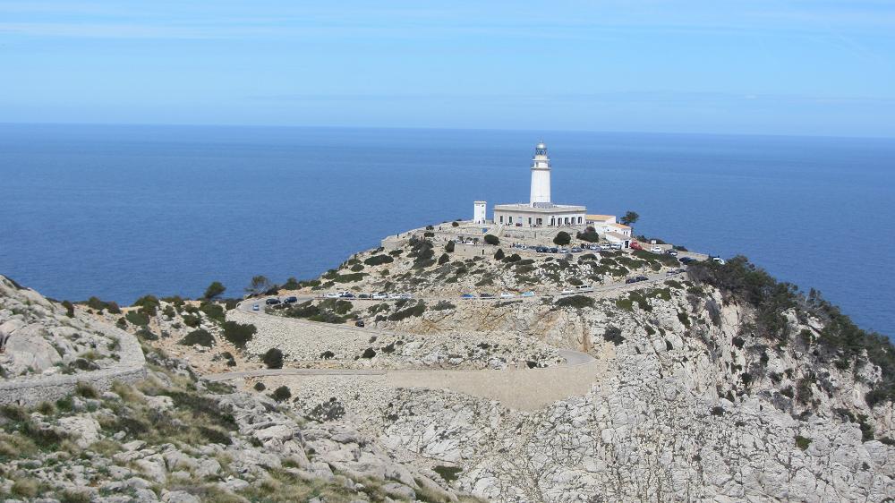
Cap deFormentor, un impresionante acantilado.
El punto más alto es el Fumart con XXX metros sobre el nivel del mar, y sus bahías asociadas Fiquera Cala, Cala Murta y Cala Pi de la Posada se encuentran en el punto de la isla de Mallorca situada más al norte. La carretera kilometro 13.5 de Port de Pollença hasta el cabo de Formentor, fue construido por el ingeniero italiano Antonio Paretti. "Al llegar al Cabo, se tiene una magnífica vista de las montañas.
Para iniciar esta caché, tengo un par de preguntas.
Primero ¿Cuál es la mayor encuesta de Formentor?
Segundo ¿Qué roca es el ingrediente principal en ese rango?
Tercera Cuáles son los dos minerales, la roca se compone principalmente?
Cuarto Por lo que la roca deseada se descompone?
Quinto (Opcional) Si desea modificar y personalizar una fotografía o un dibujo de este entorno único.
Envíe susrespuestas a: Formentor@ist-einmalig.de
Deutsch
Cap deFormentor, eine beeindruckende Steilküste.Der höchste Punkt ist der Fumart, mit XXXMetern über dem Meeresspiegel, und seine dazugehörigen Buchten Cala Fiquera, Cala Murta und Cala Pi de la Posada liegen am nördlichsten Punkt der Balearen-Insel Mallorca. Die 13,5 Kilometer lange Straße, die von Port de Pollença zum Cap de Formentor, wurde von dem italienischen Ingenieur Antonio Paretti "gebaut. Nach der Ankunft am Kap, hat man einen herrlichen Blick auf die Berge.
Um diesen Cache zu loggen, habe ich ein paar Fragen.
1. Wie hoch ist die größte Erhebung auf Formentor?
2. Welcher Stein ist der Hauptbestandteil in diesem Bereich?
3. Aus welchen beiden Mineralien, besteht das Gestein hauptsächlich?
4. Durch was wird das Gestein zersetzt ?
5. (Optional) Wenn Sie wollen, können sie ein Bild oder eine Zeichnung von dieser einzigartigen Umgebung einstellen.
Senden Sie Ihre Antworten an: Formentor@ist-einmalig.de
Englisch
Cap de Formentor, an impressive cliff with the highest point being Fumart some XXX meters above mean sea level, and its coves Cala Fiquera, Cala Murta and Cala Pi de la Posada lie at the northernmost point of the Balearic island of Mallorca. The 13.5-kilometer road leading from Port de Pollença to Cap de Formentor, was built by the Italian engineer Antonio Paretti".
Upon arrival at the Cape, one has a magnificent view of the mountais.
To log this cache, I have a few questions.
1. What is the High of the largest survey on Formentor?
2. Which rock is the main ingredient in that range?
3. Which two minerals, the rock consists mainly?
4. By which the desired rock is decomposed?
5. (Optional) If you want to customize and personalize a picture or a drawing of this unique environment.
Send your answers to: Formentor@ist-einmalig.de