There seem to be as many pronunciations of “Caisteal
Abhail” as there are people on Arran but this handy
guide provides the one I use:
http://www.henleyandbrown.plus.com/walking/info/corbetts_list.html.
From there it’s a crude corruption to get the cache
name.
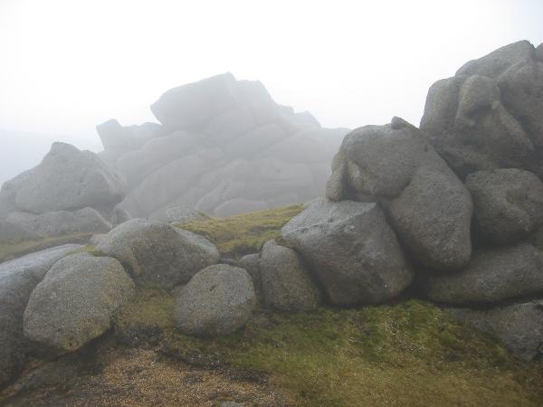
Caisteal Abhail is the most northerly Corbett on Arran
with a wide flat expanse and several impressive tors at the
top. There are many routes up to the cache and all offer a
strenuous day out. If you’re a hill walker looking for
more of a challenge than Goatfell, this would be a great
choice. All serious Arran walking guides I’ve seen
include Caisteal Abhail in one or more walks. Follow
a guide and do check the weather forecast before setting out; when
the cloud suddenly comes down it’s easy to become
disorientated.
Look out for some excellent lower-level caches that you could
visit on the same hike. If you don’t quite get to this one,
your day could still notch up some finds and the views from them
are almost as good.
There are lots of routes and variations to choose from. Some
I’ve done are:
1. From Glen Sannox up to Suidhe Fhearghus on the
northern ridge, then over/around the Witch’s step (Ceum
na Caillich). Most walking guides explain the easiest
way to negotiate the Witch’s step but it does still involve a
scramble out of the “notch”. The reverse direction is,
in my opinion, much harder.
2. Along Glen Rosa, up to Cir Mhor (“Keer
Voar”) and around the lip of the corrie Coire na
h-Uaimh. A longer spectacular route, and avoids the
Witch’s step.
3. From the carpark at North Sannox Bridge, alongside the
burn, then across to the ridge above the corrie Garbh
Choire. It's a bit boggy after crossing the burn but it
has fewer steep sections than other routes.
The cache is not on the summit – if you can work out
where that is! – but there is easy walking to it on good
paths, once in the general area. Keep to the paths or flat ground
even if your GPS indicates otherwise! The cache can be
located without going near an edge or a serious scramble (except
for the Witch’s step, if that’s the route you took).
Once at the coordinates, you should find it
quickly. I’ve put in some items that might help in a
minor emergency, not least a swarm of the dreaded Scottish midge
Culicoides Impunctatus. Please do not take
those items unless you really need them. There’s a
small box of things to swap too. Close the box tightly
and leave it upright in its hiding place so the rain can’t
get in. Before moving on, look south to the pyramidal Cir
Mhor, the “Saddle” snaking up to North
Goatfell and to Goatfell itself.
Be aware that the weather changes rapidly on these island
ridges. In fact, that’s what happened to us as we
hunted for a good location. We only had time to scribble a welcome
note (difficult in the rain) and headed down to lower ground.
All the usual hill walking advice applies to this cache –
take a paper map, a magnetic compass, waterproofs, torch, mobile
phone etc. and let someone know where you’re going. Have a
safe, wonderful day!