Caldera de Los Cuervos

English version
This Earthcache has been nominated on GeocachingSpain awards 2015 to be one of the best caches of the year 2015. See note from 28.11.2016.
The Caldera de Los Cuervos is an important part of the geological heritage of Lanzarote. In order to guarantee the conservation of the space, you have to follow only the marked paths. Wandering off of these paths is stricly forbidden an punishable.
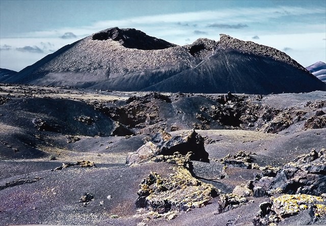
The trail “Camino de la Caldera de Los Cuervos” is over ca. 3 km. It is a circular route of low level of difficulty. It offers a comfortable visit of the first volcano, created during the Timanfaya eruption (1730-1736). Its central crater began erupting on 1st of September 1730, giving rise to the most important volcanic eruptions in the history of the Canary Islands. At 10 infoboards along the trail you will get more informations.
The Caldera de Los Cuervos is a typical example of the type of volcanoes you can find in the island: simple craters of relatively reduced dimensions which can only erupt once, forming spectacular structures made up of lava fragments.
Conditions for logging:
1. Send me an e-mail. It would be kind and helpful if it would contains the German word "Loganfrage" as heading.
2. Nearby the coordinates 28° 59.586 W 13° 41.497 about 100 m in the north, you will see a big erratic block. How was it moved to this place? See infoboard.
3. At the coordinates N28° 59.514 W13° 41.520, inside of the crater, you will find a rock of the size of about 8 m. It's looking like a huge loaf of bread which is broken in two parts. In the gap you will see a heart-like inclusion. What is its calour? Name of the mineral?
4. Make a photo from any place, inside or outside of the crater, with you and your GPS. This is optional!
5. Send to me by internet the answers of questions #2 and 3#. Than you can log without waiting for my logpermission. Optional a foto (#4) would be nice. Log entries without a separate e-mail with your answers to the questions will be deleted after two weeks.

Versión española.
Este caché ha sido nominado a los premios GeocachingSpain awards 2015. See note from 28.11.2016.
El camino de la Caldera de los Cuervos es un itinerario circular de aprox. 3km con una dificultad escasa que hace posible cómodamente la visita del primer volcán creado durante la erupción de Timanfaya (1730-1736). Su cráter central entró en erupción el 1 de septiembre de 1730. Así comenzaban las erupciones más importantes en la historia de las Canarias. En diez tableros de información en el margen del camino se recibe más hechos.
La Caldera de los Cuervos es un ejemplo inmejorable y típico de los volcanes del archipiélago: cráteres simples y relativamente pequeños que entran en erupción una sola vez creando construcciones de fragmentos de lava muy espectaculares.
Condiciones de la bitácora.
1. Mándame un email. Tiene que contener la palabra alemana “Loganfrage” como asunto.
2. Muy cerca de las coordenadas N 28° 59.586 W 13° 41.497 se puede ver una roca errático (aprox. 100m al norte). ¿Cómo llegaba a este espacio? Véase el tablero de información.
3. En las coordenadas N 28° 59.514 W 13° 41.520, en el cráter del volcán, se encuentra una piedra con un tamaño de aprox. 8m. Está roto en dos partes. En la grieta se ve una inclusión con forma de corazón. ¿Qué color tiene? ¿Cómo se llama el mineral?
4. Haz una foto de ti y tu GPS dentro o fuera con el volcán en el fondo. (voluntario)
5. Escribe tu entrada de bitácora en el internet con una foto tuya sin esperar mi aprobación. Inscripciones de bitácora sin email con las respuestas a las preguntar sean borradas dos semanas después.

Deutsche Version.
Dieser Earthcache wurde durch GeocachingSpain awards 2015 zu einem der besten Caches des Jahres 2015 nominiert. Siehe Note vom 28.11.2016.
Die Caldera de Los Cuevos ist ein wichtiger Teil des geologischen Naturerbe von Lanzarote. Um dieses Gebiet besuchen zu dürfen, muss der Besuch auf den ausgeschilderten Wegen erfolgen. Sich außerhalb der Wege zu bewegen ist verboten und ist strafbar.
Der Rundwanderweg „Camino de la Caldera de Los Cuervos“ führt Dich mit geringem Schwierigkeitsgrad über eine Strecke von ca. 3 km. Er erlaubt auf bequeme Weise den ersten Vulkan zu besuchen, der während der Ausbrüche von Timanfaya (1730-1736) entstanden ist. Sein zentraler Krater brach am 1. September 1730 aus. Hiermit begannen die größten Ausbrüche in der Geschichte der Kanarischen Inseln. An 10 Informationstafeln bekommst Du zahlreiche weitere Erklärungen.
Die Caldera de los Cuervos ist ein typisches Beispiel für den Vulkantyp, den wir auf dem Archipel vorfinden: einfache, relativ kleine Krater, die nur ein einziges Mal ausbrechen und spektakuläre Gebilde aus Lavafragmenten bilden. .
Logbedingungen.
1. Schicke mir eine E-Mail. Sie muss als Überschrift das Wort „Loganfrage“ enthalten.
2. In der Nähe der Koordinaten N 28° 59.586 W 13° 41.497 siehst Du 100 m nördlich einen erratischen Felsblock. Wie kam dieser dort hin? Siehe Infotafel.
3. Bei den Koordinaten N28° 59.514 W13° 41.520, im Krater des Vulkans, findest Du einen ca. 8m großen Stein. Dieser ist in zwei Teile gebrochen. Im Spalt siehst Du einen herzförmigen Einschluß. Wie ist seine Farbe? Wie heißt das Mineral?
4. Mache ein Foto von Dir mit Deinem GPS an einer beliebigen Stelle innerhalb oder außerhalb mit der Caldera als Hintergrund. (Das ist freiwillig!)
5. Schreibe Deinen Logeintrag im Internet zusammen mit dem Foto von Dir, ohne meine Logfreigabe auf deine E-Mail mit der Beantwortung der Fragen abzuwarten. Logeinträge ohne separate E-Mail mit der Beantwortung der Fragen werden nach zwei Wochen nachträglich gelöscht.
Waldi40 earned GSA's highest level: