"WORLD'S WORST ROAD" Traditional Cache
-
Difficulty:
-

-
Terrain:
-

Size:  (regular)
Please note Use of geocaching.com services is subject to the terms and conditions
in our disclaimer.
Doing the Gillies Highway you might want to stop at the trailhead of "the worst road in the world"*, a place of historical significance** which offers a  great view, too.
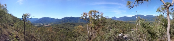 To the North you will see Little Mulgrave and numerous unnamed hills around. Eastwards are Djarragun - Walsh’s Pyramid 922m, Mount Massey 1258m, Mount Harold 1183m and Wooroonooran – Mount Bellenden Ker 1582m.
If you follow the sign "Robsons Track" to the left you will find yourself on a quite steep and troublesome narrow path. Soon you will be at the hidden treasure and enjoy an even better scenic view from here. If you like it so much you can continue the time consuming walk up until you reach GCKYJQ "Danbulla Jump Zone" at the Gillies Lookout.
 Nice weather! Happy Hunting!
 BYO pen please!
You will see a memorial plaque at the parking saying
1788-1988
ROBSONS TRACK 1880
A Horse and Mule-Packers' Trail Passed Here Between "Boar Pocket" and "Little Mulgrave Crossing" Throughout the 1880's Pioneering Herberton Tin Miners Packed 65 kms along this Track to Ports on Trinity Inlet, Cairns. In Memory of a Pathfinder and those who followed.
A MULGRAVESHIRE BICENTENNIAL PROJECT
*) The historical Robson's Track, a packhorse trail was described by Bishop Gilbert White in 1887 as "the worst road in the world" (http://www.wettropics.gov.au/ttd/ttd_goldsborough_parks.html).
**) In 1880 James Robson blazed this track to connect Boar Pocket with the coast line.
Additional Hints
(Decrypt)
Enva furygre