Note: This is an Earthcache. There is no physical cache to find. Logging this Earthcache requires that you undertake an educational task relating to the specific Earth Science at the site.
Prior to logging this cache, click on Message this owner, or send an email with answers to the following questions:
- What once covered this bedrock layer?
- What type of sandstone is found here?
- Is this sandstone older or younger than that found at the Upper Falls?
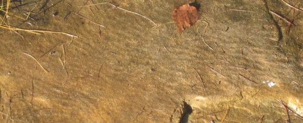
- Based on the ripples in the sandstone, what direction do you think the shoreline ran?
- Required to log this cache: Please provide a photo of yourself or a personal item in the picture to prove you visited the site. Upload the photo with your log.
Tehquamenon Falls State Park
Lower Falls and Upper Falls are fee areas within Tahquamenon Falls State Park. A daily or annual pass is required. Currently there is a traditional cache on the island here at Lower Falls, and another EarthCache and traditional cache at the Upper Falls. The same park pass will get you into both areas.
Over 500 million years ago, during the Cambrian Period, global sea levels were at relatively high elevations as compared to today. The climate was warmer than today and there were no polar icecaps or high-altitude glaciers. The world's continents were mainly low-lying deserts and alluvial plains. The rising sea encroached upon these areas forming vast epicontinental seas. During most of the Cambrian Period, the sea level was so high that it covered most of North America except for a series of low islands running southwest-northeast along the elevated middle part of the continent.
The sea floor was not flat. Many domes and basins existed in North America in the Precambrian rock. This area was at the edge of the Munising Basin. As the seas receded, this basin became an inland sea, and the shoreline wave action is recorded in this layer of sandstone.