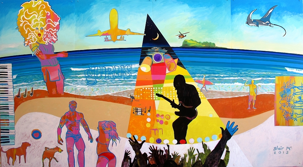
 Image 1: McNamara, B 2013, Beach Escape and Memories of Surfair, Mural - Acrylic paint, Public Art Collection - Suncoast Boulevard, Marcoola
Mudjimba Island
A RESTRICTED PERMIT under the 'Maroochy River Conservation Park Management Plan' for an EarthCache (EC), which is a non-physical Geocache, has been granted by 'Queensland Parks and Wildlife Service' (QPWS) for this location. This permit has been lodged with EarthCache.org and can be requested from the EarthCache Owner (ECO).
The restriction and requests by QPWS for this permit are as follows:
- Access is not permitted to the actual vegetated grounds of the island due to high conservation values and nesting muttonbirds (wedge-tailed shearwaters). About 4,000 muttonbirds use the island during breeding season, and have built about 2,000 burrows where the females lay their eggs. The permit has only been granted for access to the rocky outcrop that surrounds the island to protect the vegetated areas of the island and its fragile inhabitants.
Please see reference image below, as all thatched in red is restricted and must not be entered:
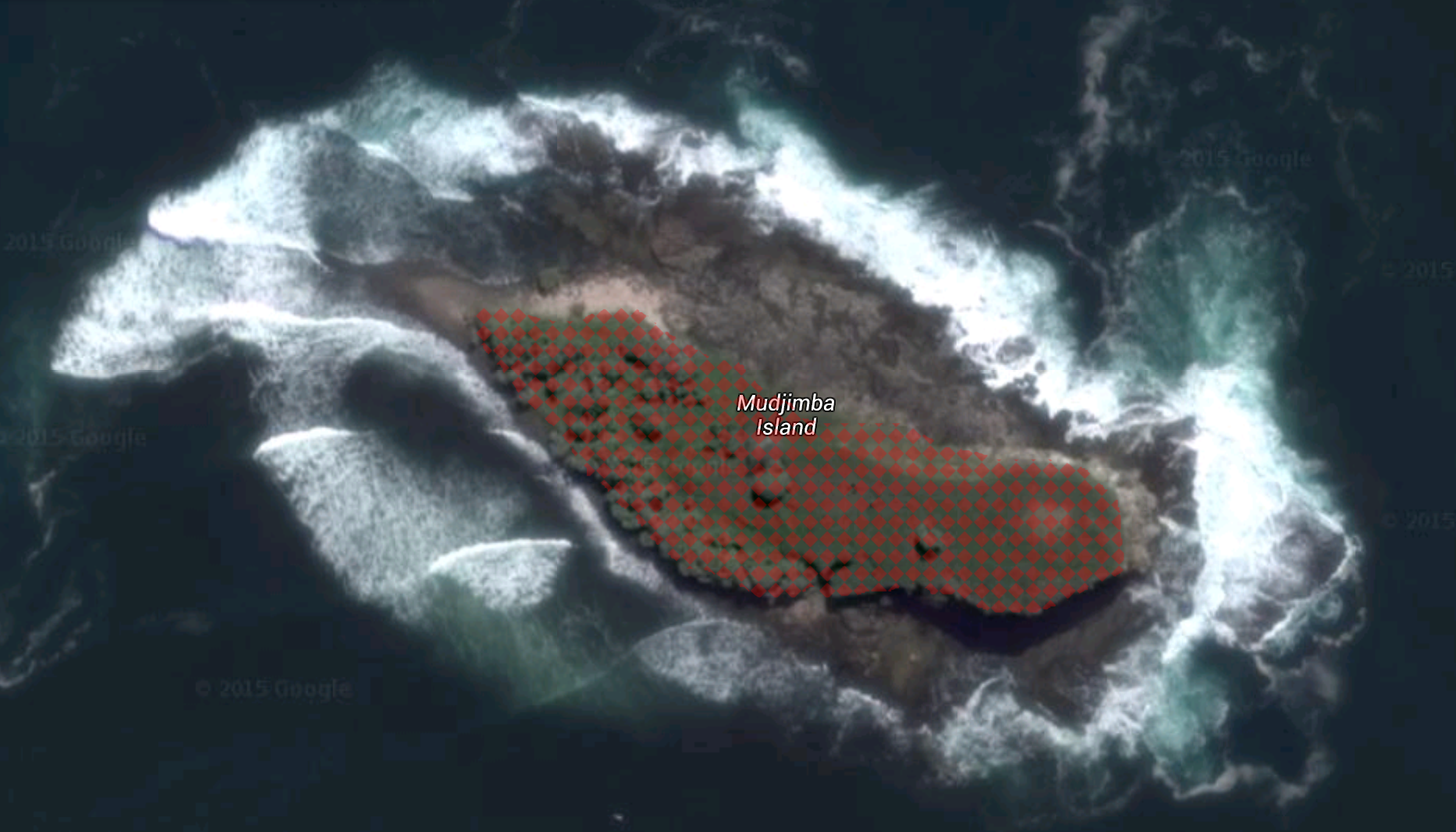
Image 2: Imagery 2015 DigitalGlobe, Map data 2015 Google, Mudjimba Island [-26.614517, 153.114500] as at 12.07.15
- There is no designated boat landing site and the surrounds are tide dependant. Beware the surrounding waters have large underlying rocks, hidden outcrops and strong currents. Please note and understand the section 'Island Access' and agree to the section 'Disclaimer' before attempting this EC.
- It has been requested from QPWS that we help to improve the island that they are trying to preserve. Rubbish is an issue on the island due to it constantly being washed up. The ECO normally says "Visit like you were never there", though this time we want to show a positive impact by taking away what has been left behind by others. Please collect rubbish whilst on the island and dispose of it correctly. Make it look like no one was ever there!

Geographical Location:
Mudjimba Island sits just off the coastline of Mudjimba, a coastal-urban area between Coolum Beach and Maroochydore on the Sunshine Coast and is 100kms north of Brisbane, Queensland. Side fact: The suburb of Mudjimba was actually named after Mudjimba Island, as the island was named first.
*** CLICK HERE for a LIVE webcam of Mudjimba Island, Mudjimba & Marcoola ***
Mudjimba Island:
The popular coastal landmark is a well vegetated, rocky islet about 1.3kms east of Mudjimba and is accessible only by sea. The total area covered by the island is 1.1 hectares and it is surrounded by a wave cut platform which extends out to a rocky reef. The island goes by several names to the locals, with the main being Old Woman Island, then also Whale Island and Kong's Island. The island is said to hold the best surf break in the Sunshine Coast Region, if not Australia, with surfers making the journey daily to surf the perfect break.
The island falls within the 'Maroochy River Conservation Park' and is protected under the 'Nature Conservation Act 1992'. The island is overseen and cared for by the QPWS who have been kind enough to allow Geocachers restricted access to the island.
Not much research or scientific attention has been given to the island nor its historical background. Proposals are in place to preserve the ecology and develop a better understanding of its history.
Island Geology:
The island that we now call Mudjimba Island was formed between 32 to 22 million years ago during the Paleogene Period, though the creation was something extremely violent and in no way something done overnight. Its formation started alongside the more famous Glasshouse Mountains which are scattered across the coastal plains.
After the separation of Australia from the ancient super-continent that was Gondwana over 65 million years ago, Australia broke away slowly but dramatically from Antarctica and began drifting northwards. Whilst shifting, the continent moved over a 'hotspot' (now called the 'East Australian hotspot') in the Earth's mantle beneath the crust. This happened between 30 and 22 million years ago and caused prolonged volcanic activity that would rock south-east Queensland for millions of years to follow.
In the Maleny district approximately 29 million years ago, one or more major volcanoes began to erupt basalt lava flows, filling the valleys of the district and eventually building up broad, gently sloping plains and shield shaped mountains.
About 3 million years later the volcanoes began to settle and cap. During this time, the somewhat rounded and uniform landscape began to dramatically change. Due to the back-pressure of the settling volcanoes, many volcanic vents were filled and clogged with magma. Once the magma had cooled this caused what is referred to as a plug, such as Mount Beerwah. In addition, dome-like pockets of magma were forced through the surrounding older rocks though not actually breaking the surface and formed laccoliths (such as Mount Coolum).

Image 3: Glasshouse Mountains Formation, Diagram, Mary Cairncross Scenic Reserve
[http://www.mary-cairncross.com.au/glasshouse-mountains-geology.php]
When the above formations were cooling and settling they would crack and shift allowing pressurised magma to fill the gaps. Once cooled, the magma turns to rock and the formation is then referred to as a dyke. These dykes are a body of magma that cuts through (and across) adjacent rock in sheets. It is similar to a secondary volcanic vent, allowing a reduction in pressure, but does not strike through the surface. It is always younger than the rocks which surround it and occurs in all different widths and lengths.
Over millions of years all of the above mentioned activity with the effects of erosion have sculptured the Glasshouse Mountains and shaped the Sunshine Coast we see today.
When examining Mudjimba Island from the Observation Waypoint, the above volcanic impact is identifiable by visible layers of a soft, light-coloured Landsborough Sandstone which is of Jurassic age (approximately 190 million years) and a much younger though harder, dark-coloured basalt rock of which is around 26 million years old.
The island protrudes 25 metres high from above the ocean though most of this sea-bound mountain is hidden within the depths of the Coral Sea.
The reef surrounding the island is known as subtidal and intertidal and consists of large rocky boulders and a rock wall drop-off ranging from 3-11mtrs. All of this rocky reef makes home to the largest amount of nudi branches found on the east coast of Australia. It is also home to turtles, stingrays, cuttlefish, an abundance of small tropical fish and hard corals.
Dreamtime Legends:
The island is the subject of at least two Aboriginal legends:
One involved two women making a home on the island, where midyim berry bushes grew plentifly. When only one of the women could be seen on the island, it became nicknamed as Old Woman Island. The true name of this island came from the midyim berry bush - hence 'midyam' becoming altered to 'Mudjimba'.
A second legend interpreted the island as being the head knocked off the top of a warrior, Coolum, which is represented as the flat-topped Mount Coolum about 6kms northwards. The story involves two mighty men Coolum and Ninderry and a woman named Maroochy. In a climatic battle Ninderry knocked Coolum’s head from his shoulders into the sea to lie where it is today as Mudjimba Island. For the full Dream Time Legend of this area please Click Here.
What Once Was:
When exploring around the rocky outcrops be sure to look across the island as you will see the remains of old residences. The island, which is Crown land, had 5 leases between 1948-1968. In 1968 a special 30 years lease allowed for residential use of the 1.1 hectare island. This was sold 4 times with the last residents vacating the island in 1991.

Image 4: Dunn, R ca1990, Residence on Mudjimba Island, Photograph, Loaned - Heritage Library [BRN: 349]
Island Access:
Please understand your capabilities before attempting and never venture out alone. Advanced preparation is crucial for success; Pay attention to all weather conditions and DO NOT attempt this EC if the ocean is rough, there is high swell, strong winds, bad weather is current/pending or if the launch beach is closed. As the island is out past the shark nets, the surrounding ocean is freely open to large marine life.
*** CLICK HERE for the weather forecast for Mudjimba Island ***
*** CLICK HERE for a LIVE webcam of Mudjimba Island, Mudjimba & Marcoola ***
The best launch for the island when swimming, paddling or traveling by hand-powered craft is considered to be Mudjimba Beach and on the back of an outgoing tide. The observation waypoint may not be accessible at high tide and definitely not during a king tide.
Mudjimba Beach is where the ECO launched with a kayak when researching this EC at 0800 on 28/06/15 with a low outgoing tide and challenging medium swell. Once breaking through the waves, the journey is quite pleasant. It is said that if you are travelling by boat it is best done from the Maroochy River. Though, once you are close to the island, the rocky outcrop begins and you will have to make it to shore via other means, as a boat will not get you close enough! (Anyway you attempt it, you're getting wet!). Keep in mind, the easiest part is getting on the island, the hardest part is getting off it!
The best access to the actual island is considered to be via a rocky beach running around the north-western side of the island which consists of only rocks, very large kayak scratching, blood drawing, painfully sharp rocks. There is a strong chance that your kayak will get scratched on entry and shoes are a must or you may get scratched to! The waves wrap around the island so you need to get your timing right. Coming in on the back of a set waves and getting onto the rocky bank before the next set cleans you up could be your best approach. Remember, this adventure is not recommended for days with large swell and entrance to the island is only by light hand-powered craft or by swimming.
Logging Requirements:
To qualify and log this EC you must have actually set foot on Mudjimba Island and physically located the Observation Zone waypoint. From your observations and in the information provided in this listing you must also complete the following questions:
Q1) Once at the Observation Zone waypoint, looking across the rock-face and where you are standing, there are two prominent rock types. One of these being Landsborough Sandstone and the other Basalt.
Q1.A) From the section 'Island Geology', identify which type of rock you are standing on and which rock is visible on the upper face of the cliff.
Q1.B) When observing and/or feeling the two rock types, what are three differences?
Q2) Between the two caves in front of you, is a distinctive feature in the rock.
Q2.A) What is it?
Q2.B) How was it formed?
Q2.C) At its widest point, estimate how thick is it vertically?
Q3 ) What forces are having effect on this island and how will this effect the island in the future?
Optional (legend status proving) task:
Capture and share your adventure by taking a photograph of yourself/team/GPSr and collected rubbish with the way-pointed 'Mudjimba Island Conservation Park' sign in the background and remember to not access any of the restricted area.
Please send your answers by eMail to the ECO, do not use the new message centre. Do not include answers in your log nor post photos of the Observation Zone. You do not need to wait for the ECO's reply before logging. If there is a problem with your answers you will be contacted for clarification. More than one Geocacher may log the cache with one eMail, but all Geocachers must have set foot on Mudjimba Island and physically located the Observation Zone Waypoint. In addition, all names must be included in the originating eMail.
Special Thanks:
Thank you to the Rangers at 'Queensland Parks and Wildlife Services' for their interest and for allowing a restricted permit to be given for the purpose of Geocaching on the island.
A personal thanks must go to local Muggle surfers Melissa Gaudart and Greg Shanks for accompanying the ECO on their surfboards to research and surf the island.


Disclaimer:
Always exercise common sense and caution while Geocaching. Any person attempting this EarthCache and/or any related activities assumes all liabilities and personal responsibility for any and all damages or injuries of any kind. If you do not agree to these terms and conditions, do not attempt for this EarthCache.
References
Text References
Barraclough, E., sunshinefraserpermit@npsr.qld.gov.au, 2015. Geocaching Mudjimba Island. [E-mail] Messages to McDougall, C. (minkosdes@gmail.com). Sent between 29 June - 9 July 2015. Available at: On Request [Correspondence reference between 29 June - 9 July 2015].
Office of the Queensland Parliamentary Counsel. 2015. Nature Conservation Act 1992. [ONLINE] Available at: https://www.legislation.qld.gov.au/legisltn/current/n/naturecona92.pdf. [Accessed 09 July 15].
Queensland Parks and Wildlife Service. 1999. 'Maroochy River Conservation Park Management Plan' . [ONLINE] Available at: http://www.nprsr.qld.gov.au/managing/plans-strategies/pdf/maroochy-river-conservation-park-2000.pdf. [Accessed 09 July 15].
Wikipedia.org. 2015. Mudjimba, Queensland. [ONLINE] Available at: https://en.wikipedia.org/wiki/Mudjimba,_Queensland. [Accessed 12 July 15].
Wikipedia.org. 2015. Paleogene. [ONLINE] Available at: https://en.wikipedia.org/wiki/Paleogene. [Accessed 18 July 15].
Department of National Parks, Sport and Racing (NPSR). 2015. About Glass House Mountains. [ONLINE] Available at: http://www.nprsr.qld.gov.au/parks/glass-house-mountains/about.html. [Accessed 20 July 15].
Wikipedia.org. 2015. East Australia hotspot. [ONLINE] Available at: https://en.wikipedia.org/wiki/East_Australia_hotspot. [Accessed 20 July 15].
Mary Cairncross Scenic Reserve (MCSR). 2015. The Glass House Mountains tell a story. [ONLINE] Available at: http://www.mary-cairncross.com.au/glasshouse-mountains-geology.php. [Accessed 20 July 15].
GeoAwareANZ, EC Reviewer. (2015), Several conversations with MinkosDes. Discussions of a Mudjimba Island EarthCache. [DIGITAL SOURCES] Available at: On Request [Held: 28 June - 18 August 2015].
Australian Museum . 2009. Igneous intrusions. [ONLINE] Available at: http://australianmuseum.net.au/igneous-intrusions. [Accessed 20 July 15].
Underwater Australasia. 2015. Sunreef Mooloolaba. [ONLINE] Available at: https://underwater.com.au/listing/id/1176-sunreef-mooloolaba/. [Accessed 20 July 15].
Centre for the Government of Queensland. 2015. Queensland Places, Mudjimba. [ONLINE] Available at: http://queenslandplaces.com.au/mudjimba. [Accessed 20 July 15].
Sunshine Coast Council. 2014. Local Indigenous Heritage. [ONLINE] Available at: http://library.sunshinecoast.qld.gov.au/sitePage.cfm?code=heritage-swan-indigenous. [Accessed 20 July 15].
Dunn, R. 2008. (via Sunshine Coast Libraries.) Residence on Mudjimba Island. [ONLINE] Available at: https://sunshinecoast.spydus.com/cgi-bin/spydus.exe/ENQ/OPAC/BIBENQ?BRN=349 . [Accessed 20 July 15].
Dr Ray Kerkhove for Bunya Bunya Corp. 2016. Aboriginal Cultural SitesLower Maroochy & Mooloolah Rivers:Some Research Findings. [ONLINE] Available at: https://www.academia.edu/27113711/Aboriginal_Cultural_Sites_Lower_Maroochy_and_Mooloolah_Rivers_Some_Research_Findings . [Accessed 8 March 20].
Visual References
Image 1: McNamara, B 2013, Beach Escape and Memories of Surfair, Mural - Acrylic paint, Public Art Collection - Suncoast Boulevard, Marcoola. [ONLINE] Available at: https://sunshinecoast.spydus.com/cgi-bin/spydus.exe/FULL/OPAC/ALLENQ/23524244/48120010,8. [Accessed 20 July 15].
Image 2: Imagery 2015 DigitalGlobe, Map data 2015 Google, Mudjimba Island [-26.614517, 153.114500]. [ONLINE] Available at: https://goo.gl/maps/bwxXhvHb5hL2. [Accessed 20 July 15].
Image 3: Glasshouse Mountains Formation, Diagram, Mary Cairncross Scenic Reserve. [ONLINE] Available at: http://www.mary-cairncross.com.au/glasshouse-mountains-geology.php. [Accessed 20 July 15].
Image 4: Dunn, R ca1990, Residence on Mudjimba Island, Photograph, Loaned - Heritage Library [BRN: 349]. [ONLINE] Available at: https://sunshinecoast.spydus.com/cgi-bin/spydus.exe/FULL/OPAC/ALLENQ/23524244/349,31. [Accessed 20 July 15].
Operational Research References
Gaudart, M. (2015), Several conversations with McDougall, C. Discussions of a Mudjimba Island Adventure. [IN PERSON] Available at: Non-Transcripted [Held: January - July 2015].
WillyWeather. 2015. Mudjimba Beach, QLD. [ONLINE] Available at: http://www.willyweather.com.au/qld/sunshine-coast/mudjimba-beach.html. [Accessed 23 - 28 June 15].
Coastal Watch. 2015. Marcoola Surf Cam & Surf Report. [ONLINE] Available at: http://www.coastalwatch.com/surf-cams-surf-reports/qld/marcoola. [Accessed 26 - 28 June 15].
Department of National Parks, Sport, Recreation and Racing. 2015. Operational Policy, Geocaching on QPWS managed areas. [E-mail Attachment] Available at: On request from Department of National Parks, Sport, Recreation and Racing. [Accessed 9 July 2015].
Queensland Parks and Wildlife Service (QPWS). 2015.Geocaching Application Form. [E-mail Attachment] Available at: On request from Queensland Parks and Wildlife Service (QPWS). [Accessed 9 July 2015].
EarthCache Organisation. 2015. EarthCache Website. [ONLINE] Available at: http://www.earthcache.org/. [Accessed 20 July 2015].
Build
Listing written in Google Chrome for OS X, Version 49.0.2623.87 (64-bit). [Last updated 7 March 2020 (correction of image links)].
Listing approved and published by GeoAwareANZ, Earthcache Reviewer for Groundspeak, on 18 August 2015.
W3Schools. 2015. HTML(5) Tutorials. [ONLINE] Available at: http://www.w3schools.com/html/. [Accessed 09 July - 02 August 2015].
Portugal Geocaching and Adventure Portal. Gerador de FTFs . [ONLINE] Available at: http://www.geopt.org/index.php/ftfs/gerador-ftf. [Accessed 20 August 2015 - 26 March 2016].