Even with the close popular sightseeing spots that are usually very busy, this hidden treasure is often deserted. Part of the reason is that the road to Childers Cove is not prominently marked. About 15 kms west of the Bay of Islands viewing area on The Great Ocean Road is the turn off onto Childers Cove Road. It is a narrow sealed road for a further 6 kms to the group of coves and beaches. The only traffic on Childers Cove Road is an occasional farm vehicle. The road is through open farmland so quite an easy drive.
The Bay of Islands Coastal Park are within an area of high geological and geomorphological significance. Collectively, the geological exposures and landforms within the park form an area of national significance. Individual significant sites have been identified that illustrate either contemporary or past geological and land forming processes. The high significance rating is based on the excellent displays of sedimentary rocks in the coastal cliffs and the variety of coastal and karst landforms related to both past and present geomorphological processes.
The geology of the Parks comprises marine limestones of the Tertiary (Oligocene to Miocene) age overlain by Pleistocene dune limestones. Former cliffs developed at higher sea levels or now isolated from wave action by beaches, dunes or rock debris have declined in slope to become vegetated bluffs with a mantle of weathering debris and soil, and are subject to less frequent or catastrophic change. Many of the significant geoscience features are a direct consequence of erosion from high wave energy, strong winds, and intense rainfall and runoff events. This process exposes the Tertiary rock formations and produces the various cliff and shoreline features. If sea level remains constant or there is a sea level rise, continued cliff erosion will cause the coastline to retreat, and the area of the present Parks will be reduced. Coastal features will change, especially those with arches, overhanging cliffs or caves. If sea level falls or there is a marked reduction in wave energy along this coastline, the rate of coastal recession will reduce and presently active cliffs will degrade into more stable coastal bluffs. Fragments, slabs or blocks of rock occasionally detach from the cliff face, and linear segments of the cliff fail by falling, sliding or slumping. The joint fracture planes and the weak consolidation of many rocks determine the rate and direction of erosion and the location of cliff failures.
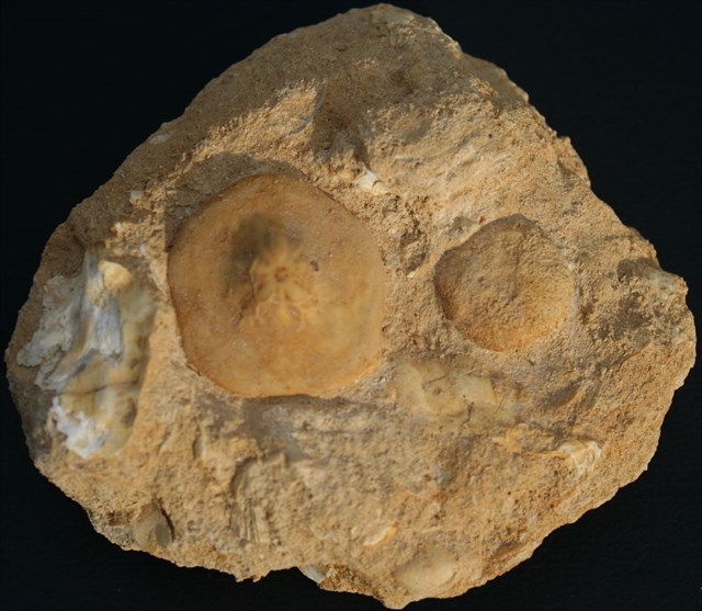
Miocene Limestone with a fossil embedded
Limestone is partially soluble, especially in acid, and therefore forms many erosional landforms. These include limestone pavements, pot holes, cenotes, caves and gorges. Such erosion landscapes are known as karsts. Limestone is less resistant than most igneous rocks, but more resistant than most other sedimentary rocks. It is therefore usually associated with hills and downland, and occurs in regions with other sedimentary rocks, typically clays. Karst topography and caves develop in limestone rocks due to their solubility in dilute acidic groundwater. The solubility of limestone in water and weak acid solutions leads to karst landscapes. Regions overlying limestone bedrock tend to have fewer visible above-ground sources (ponds and streams), as surface water easily drains downward through joints in the limestone. While draining, water and organic acid from the soil slowly (over thousands or millions of years) enlarges these cracks, dissolving the calcium carbonate and carrying it away in solution. Most cave systems are through limestone bedrock. Cooling groundwater or mixing of different groundwaters will also create conditions suitable for cave formation.
Q1 Describe the colours you see here in the cove rock.
Q2 Describe the vast differences in the rock faces of the cove to the left and right.
Once you complete the EarthCache requirements you can post your find without delay, as per the EarthCache guidelines. You will also need to verify your find by sending me a message and provide your answers to the questions.
For a link to my profile, click here - Na'wal
Thanks for visiting this Earth Cache. Hope you enjoy the location.

Feel free to attach photos to your log (optional)

References ~ Parkweb Victoria, wikipedia