
This cache is at a roadside park near Honor. Notice the topography and elevation of the area - a hillside to the north and the Platte River to the south, with the artesian well at the listed coordinates in between. Read the following narrative to understand how the artesian well at the listed coordinates works due to the topography and the geology in the vicinity of the well.
INTRODUCTION
Flowing artesian wells are water wells where the pressure in the aquifer (waterbearing geologic formation) forces ground water above the ground surface so that the well will flow without a pump. Several methods are used to construct flowing wells and to control the discharge of water from the well. To ensure that the artesian properties of aquifers are preserved and that environmental and personal property damage do not occur, water well contractors need to be fully prepared when completing wells in areas where flowing wells are encountered. Understanding flowing wells is important for health officials and others who evaluate the sanitary integrity of drinking water supplies. Water storage and distribution piping arrangements on existing flowing well systems vary considerably from conventional water well systems. Inspectors conducting sanitary surveys of older flowing well systems may encounter cross connections that pose a health hazard to users of the water system.
A perception that Michigan’s ground water supply was limitless, combined with poor well casing sealing practices when flowing wells were constructed in the past, resulted in the wasteful and unnecessary discharge of an enormous amount of ground water. If all of the flowing wells drilled in Michigan in 2001 were allowed to discharge to surface without any volume reduction, about 28 million gallons of ground water would be released from artesian aquifers each day. Uncontrolled discharges from new flowing wells would amount to over 30,000 acre-feet of ground water being wasted annually in Michigan. Diligent statewide enforcement of existing flowing well discharge control regulations helps ensure that the hydraulic properties of artesian aquifers are preserved for future generations. The areas of Michigan where flowing wells occur need to be delineated so that county well permit programs become useful tools to regulate flowing well construction practices.
FLOWING WELL OCCURRENCE
Flowing wells are found throughout Michigan and can originate from aquifers occurring in either glacial drift or bedrock. About 200 flowing well districts were identified in the Lower Peninsula of Michigan during ground water investigations conducted in the early 1900’s. Data from the water well record data base at the Michigan Department of Environmental Quality (MDEQ), shows that from June 2001 through June 2002, about 450 flowing wells were drilled in Michigan (About 3 percent of the new water wells drilled). The average flow rate from the newly drilled wells, before flow control devices were installed, was 42 gallons per minute (gpm). Forty of the wells had flow rates of 100 gpm or more. A well drilled in Section 34, Klacking Township, Ogemaw County in December 2001, using a cable tool rig, produced a geyser of water 12 feet above the top of the 4-inch casing. The well drilling contractor reported the flow rate to be 1,000 gpm.
Some of the largest flow rates reported by Leverett et al., (1907) were from two 2-inch diameter wells in Rose City, Ogemaw County. These wells reportedly flowed at 270 and 272 gpm and in combination served 25 families. In 1907, the total flow from 20 Rose City wells was 2,290 gpm or 10,000 gallons per day per resident, which was the highest daily per capita water usage for any Michigan city. In 1986, large volume, high head flows were encountered in the village of Cedar, Solon Township, Leelanau County, when several drinking water wells were replaced through a state-funded ground water contamination remediation program. A Michigan Department of Public Health official recorded shut-in pressures of 30 pounds per square inch (psi) (equivalent to a piezometric level of 69.3 feet above surface) from the 4 inch wells, which ranged in depth from 300 to 330 feet. The 200 to 450 gpm discharges were successfully controlled by installing pitless units with flowing well spools. The pressure at the wellhead was so great that when a backhoe bucket was used to push the pitless unit spool into place, the front end of the backhoe was lifted off the ground. The problem was overcome by installing a valved blow-off on the casing below the pitless unit connection, which was opened temporarily during the pitless unit installation. Allen (1977), reports an artesian head of 84 feet (equivalent to 36 psi pressure at the ground surface) from a 215 foot (ft) deep Silurian bedrock well in Section 29 of Garfield Township, near the village of Naubinway in Mackinaw County. This is thought to be the highest reported artesian head in Michigan. Two large flowing wells were reported by Brown (1970) and Swanson (1991). In 1969, a 12-inch well drilled to a depth of 334 feet was completed at Fort St. James, British Columbia, Canada. The well flowed 4,200 gpm and had a shut-in head pressure of 52 psi (equivalent to 120 feet of artesian head) (Brown, 1970). A phenomenal well to serve a commercial catfish farm in Alvin, Texas was completed in 1991. Nearly 1,600 feet of 30-inch steel casing pipe was pressure cemented and upon completion a 21,000 gpm water stream shot 25 feet in the air (Swanson, 1991). The force of the water in the Texas well was so great that it was able to lift an 85 lb. piece of a broken reaming bit out of the well.
Flowing wells have intrigued mankind for centuries. This point was illustrated by Freeze and Cherry (1979), who stated: “Flowing wells (along with springs and geysers) symbolize the presence and mystery of subsurface water, and as such they have always evoked considerable public interest.” According to Davis and DeWiest (1966), the widespread search for artesian water that occurred after the completion of flowing wells in Flanders (now Belgium and the Netherlands) around 1100 A.D., and later in the 18th century in the northern France province of Artois, Western England, and Northern Italy, was responsible for stimulating the advancement of water well drilling technology. Throughout Michigan, flowing wells have become local attractions. Among the northern Michigan towns and villages where flowing wells are abundant are West Branch, Rose City (Ogemaw County), Cedar (Leelanau County), Indian River (Cheboygan County), Onekama (Manistee County), Conway, Oden , Alanson, (Emmet County), Naubinway (Mackinaw County), and Rapid River (Delta County). Trout hatcheries and other fish rearing ponds have developed in some locations because of the availability of flowing artesian wells. In the late 19th century and early 20th century, flowing wells attracted visitors to Michigan hotels and resorts that touted the therapeutic benefits of artesian mineral waters. Today, many flowing wells in roadside parks, campgrounds, and along road right-of-ways are sources of drinking water for visitors who stop by to fill water containers.
ARTESIAN WELL CHARACTERISTICS
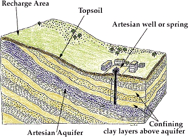
In artesian wells, water rises within the well to a point above the top of the aquifer. If the water also rises above the ground surface, the well is called a “flowing well,” or “flowing artesian well.” All flowing wells are artesian, but not all artesian wells are flowing wells. Within both confined and unconfined aquifers, the water level rises and falls in response to the volume of water within the aquifer pore space. Aquifer recharge events and withdrawal of ground water affect the water level. During pumping of a well in a confined formation, water flow to the well is the result of compression of the aquifer matrix and a lowering of the potentiometric surface. Because the water level of artesian aquifers can be influenced by barometric pressure, well owners occasionally report fluctuations of flow rates and/or turbidity production during stormy weather. Elevation and loading are two distinct hydrogeological forces that account for the development of flowing artesian wells. Artesian conditions can be either geologically-controlled or topographically-controlled.
The well taps an aquifer that is confined because of an overlying layer of geologic material that has a lower hydraulic conductivity (or permeability). The impermeable layer is called an “aquicludes.” Another geologic unit that can create artesian conditions is a slightly permeable layer which transmits some water vertically, called an “aquitard.” Water within confined aquifers (artesian water) is separated from the atmosphere by the impermeable materials. A recharge area that is at an elevation higher than the well causes loading that creates the hydraulic head that pressurizes the water within the confined aquifer. The weight of the overlying aquiclude or aquitard also exerts pressure on the water. When the well casing penetrates through the impermeable materials and reaches the artesian aquifer, pressure is released and the water rises within the well casing as it seeks equilibrium with the elevation of the water at the aquifer’s recharge area. Topography can influence hydrogeological conditions in an area and can be the controlling factor in the production of flowing wells. In unconfined aquifers, flowing wells can occur when the well intake (screen) is deep enough to intercept a zone where the hydraulic head (or pressure) value is higher than the land surface.
This typically occurs in ground water discharge areas, which are often lower areas near rivers and lakes, but can also occur in relatively flat terrains with no outcrop of the recharge area. The hydraulic head of ground water changes as it moves along flow paths from the recharge area toward the discharge area. The slope of the flow path and the resultant hydraulic head value are controlled by topography. As ground water moves along its flow path, it can travel deep below ground, where it lies beneath ground water having a lower hydraulic head. When a well is drilled into the high head zone, the resistance up the well casing is less than the resistance to water movement caused by the friction of the overlying soil. The ground water moves from the high head condition toward the low head condition and a flowing well is created.
To log this cache, please do the following items and email the answers for 2 and 3 to the cache owner.
1) Simple experiment - to show you how artesian pressure works. Fill a plastic baggie with water, put a straw in through the opening, tape the opening around the straw closed, then squeeze the baggie. Artesian water is pushed out through the straw.
2) Measure the water flow -BRING A GALLON CONTAINER. Measure the time it takes to fill the gallon container, then calculate this into gallons per minute. (If you do not have a gallon container, use a container of known volume and do the calculation.)
3) What is on the big rock near the cache?
4) OPTIONAL – take a picture with the artesian well in the background.
Source: MICHIGAN FLOWING WELL HANDBOOK by Michael S. Gaber, R.S., M.P.H., Chief, Well Construction Unit Michigan Department of Environmental Quality, Water Bureau
To learn more about earthcaches, including how to develop one of your own click here Earthcache.org. You can also obtain one or more of the following levels of the Earthcache Masters Program:
BRONZE (log three or more earthcaches in at least two or more states/countries),
SILVER (log six or more earthcaches in at least three or more states/countries and develop one earthcache),
GOLD (log twelve or more earthcaches in at least four or more states/countries and develop two earthcaches), or
PLATINUM (log twenty or more earthcaches in at least five or more states/countries and develop three earthcaches.