
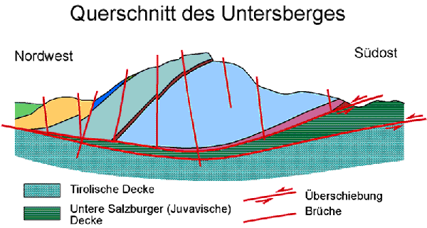
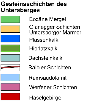
Entstehung des Untersberg:
Als Teil der Nördlichen Kalkalpen wurden die Gesteine des Untersberge vorwiegend im Erdmittelalter (Mesozoikum, vor 65 bis 225 Mill. Jahren) im Urmeer Tethys ca. 200 km südlich ihrer heutigen Lage abgelagert. Am Ende dieser Ära wurde durch den Zusammenstoß Afrikas mit Europa die Tethys geschlossen, die im Meer abgelagerten Gesteine wurden übereinander geschoben und die Entstehung und Auffaltung der Alpen begann. Dabei wurden die Nördlichen Kalkalpen vom Untergrund abgeschert und rund 200 km nach Norden verfrachtet, in mehrere Decken zerteilt und übereinander gestapelt. Bei dieser Überschiebung wurden die Gesteinsschichten zerbrochen und nach Norden gekippt.
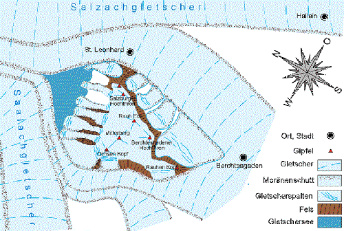
Vereisung des Plateaus:
Während der letzten Eiszeit war der Untersberg von großen Talgletschern umflossen.
Das Plateau selbst war von einem Eispanzer bedeckt. Dieser Plateaugletscher floss vorwiegend nach Norden ab. Seine schürfende Wirkung formte an der Nordflanke des Berges die von harten Felsen begrenzten Trogtäler mit Gletscherschliffen aus. Das Schmelzwasser des Gletschers hat im Vorfeld eindrucksvolle Karrenfelder hinterlassen.
Karsterscheinungen:
Das Kalkgestein des Untersbergs löst sich in Wasser langsam auf. Dort wo das Gestein durch Störungen zerbrochen ist, bildeten sich über Jahremillionen Abflusstrichter, Dolinen, sowie unterirdische Schächte und Höhlensysteme. An der Oberfläche formt das stetig abfließende Regen- und Schmelzwasser weit verzweigte Ablaufrinnen, die Karrenfelder. Das Wasser wird über Spalten und Dolinen den Höhlensystemen zugeführt. Das Wasser bleibt mehrere Tage im Berg und tritt als hervorragendes Trinkwasser in Form von Quellen wieder ans Tageslicht.
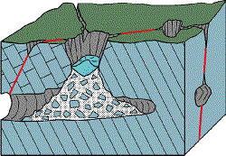
Modell einer Schachtdoline
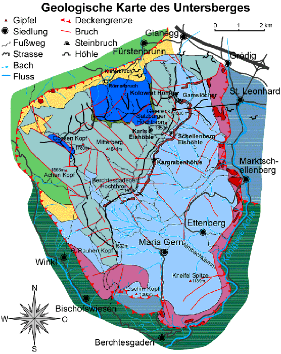
Ausdehnung und Form des Plateaus:
Das dreieckige Plateau des Untersbergs, mit den größten Erhebungen zwischen Salzburger und Berchtesgadener Hochtron, fällt sanft nach Norden hin ab. Fast der gesamte Bereich des Plateaus ist eine unwegsame, zerklüftete, mit Legföhren bewachsene Karstlandschaft, mit einzelnen Almgebieten im Norden und Osten.
Um diesen Earth Cache logen zu können musst du diese Aufgaben lösen:
1) Wie viele Tage wird das Wasser im Gestein „gespeichert“?
2) Erkläre die Struktur des Steinfeldes vor Ort?
3) Auf welchem Gestein steht das Salzburger Hochtrohn Gipfel Kreuz?
4) Optional mache ein Foto von dir am Gipfelkreuz?

Formation of the Untersberg:
Being a part of the Northern Limestone Alps, the rocks of Untersberg were primarily deposited in the Tethys Sea about 200 km south of their present location in the Mesozoic Era (65 to 225 million years ago). At the end of that era the Tethys Sea disappeared due to the collision between the African and European continent and the rocks deposited in the Sea were shoved on top of each other, which started the formation and folding of the Alps. The Northern Limestone Alps were sheared from their subsurface, pushed north about 200 km, split into several layers and piled on top of each other. In the course of this process the rock layers broke and were shifted northward.
Glaciation of the plateau:
During the last glacial period the Untersberg was bordered by vast valley glaciers. The plateau itself was covered with an ice shell, which primarily flowed north. Its abrading effect formed trough valleys bounded by hard, glacier-polished rocks on the north side of the mountain. The glacier’s melt water had already left impressing karren fields (i.e. erosions on the limestone surface) previously.
Karst features:
The Untersberg’s limestone slowly dissolved in water. Wherever the rock was fractured due to disruption, within millions of years sinkholes began to develop, called dolines, as well as subterraneous shafts and cave systems. On the surface the rain and melt water constantly created widely ramified drain channels, the karren fields. The water infiltrates the cave systems via crevices and dolines. It stays inside the mountain for several days and reappears in the form of springs being excellent drinking water.
Schema of a funnel doline
Dimension and shape of the plateau:
The triangular plateau of the Untersberg with its highest peaks between Salzburg’s and Berchtesgaden’s Hochtron gently descends northward. Almost all the plateau is an impassable, fissured karst area, covered with mountain pines, with several Alpine pastures in the north and east.
To get credit for this Earth Cache you have to complete the following tasks:
1) For how many days is the water stored within the rock?
2) Explain the structure of the rock field on site!
3) On which Rock stands the Salzburger Hochtrohn summit cross?
4) Optional: Take a picture for yourself near the summit cross!