There are many Granite outcrops in the Limpopo province. In this
Earthcache 9 km south of Polokwane we will see how this Granite
outcrop (koppie) differs from the one’s north of
Polokwane.
This site also bears evidence of occupation by Stone Age
Man.
This outcrop (Koppie) is within the Bakoni Malapa Northern Sotho
Open-Air Museum. (You don’t need to enter the Museum to do
this cache. The hiking trail is under construction for that reason
you can do the observation from out side the Museum fence.) Bakoni
Malapa is a reconstructed village in the style used by the northern
Sotho about 250 years ago designed to demonstrate the daily life of
the Bakoni, a highly sophisticated subgroup of the Northern Sotho
tribe. It’s worth a visit. Entry fee is R7.00 p/p about
US$
1.00 p/p
In this area granite (outcrops) the third foundation rock of the
Limpopo is the ancient granites. These igneous rocks were formed
about 3 billion years ago and are found over large parts of the
Limpopo Province. This is also described as the Fundamental
Complex, which forms the very foundation stone of the high South
African plateau. Many of the granite outcrops, which provide the
characteristic landscape of the African Savannah, belong to this
formation.
Granite is a common and widely occurring type of
intrusive,
felsic, igneous rock. Granite has a medium to coarse texture,
occasionally with some individual crystals larger than the
groundmass forming a rock known as porphyry. Granites can be
pink
to dark gray or even black, depending on their chemistry and
mineralogy. Outcrops of granite tend to form rounded massifs.
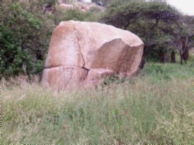
Bakoni boulder (I blur this photo you have to examine the rock
yourself)
Granite is currently known only on Earth where it forms a
major
part of continental crust. Granite often occurs as relatively
small, less than 100 km² stock masses (stocks) and in
batholiths that are often associated with orogenic mountain
ranges.
Small dikes of granitic composition called aplites are often
associated with the margins of granitic intrusions. In some
locations very coarse-grained pegmatite masses occur with
granite.
Granite has been intruded into the crust of the Earth during
all
geologic periods, although much of it is of Precambrian age.
Granitic rock is widely distributed throughout the
continental
crust of the Earth and is the most abundant basement rock
that
underlies the relatively thin sedimentary veneer of the
continents.
Granite has been extensively used as a dimension stone and
as
flooring tiles in public and commercial buildings and
monuments.
With increasing amounts of acid rain in parts of the world,
granite
has begun to supplant marble as a monument material, since it
is
much more durable. Polished granite is also a popular choice
for
kitchen countertops due to its high durability and aesthetic
qualities.
The Bakoni Koppie
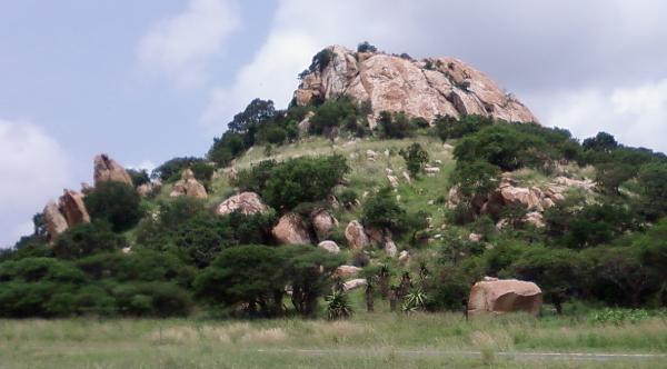
This triangular-shaped piece of ground lies entirely against
the
slopes of a series of high outcrops (koppies). The slopes
declaim
gradually to the southern and eastern borders of the area. A
basin
is formed between the outcrops (koppies) in the northern part
of
the area near the western boundary fence.
Literature tells us that the Nothern Sotho groups preferred
to
build their home structures against the foot of a koppie or
mountain, and specifically on its north-eastern slope.
During 1980 the University of the Witwatersrand did
archaeological excavations of the site. Since little is known
about
the history of the Northern Ndebele, the purpose of this study
was
to verify the written history of the Northern Ndebele with
the
archaeological explorations on the Pietersburg Plateau. The
explorations were undertaken mainly on the Ethnological museum
site
and in the Pietersburg Game Reserve. The results obtained from
the
findings of the exploration of the game reserve correspond to
those
found on the museum site, since the two sites adjoin each
other.
From this exploration it became clear that the museum site
housed a wide variety of settlers from 1600 – 1900,
viz.
Northern Ndebele, Northern Sotho and Shangaan. Various
anthropologists are of the opinion that the Northern Ndebele
occupied the site prior to the Northern Sotho (Koni of
Matlala).
According to them the Northern Ndebele lived on the site
between
1600 and 1650. When by 1700, the Northern Sotho (Koni of
Matlala)
occupied the site, they met the Northern Ndebele here.
Circa 1850 the Shangaan occupied the site. This earlier
occupation is suggested by the different stone-wall
complexes,
cattle kraals and pottery found all over the site. Apart from
the
above groups, the site also bears evidence of occupation by
Stone
Age Man, as can be seen from the stone implements identified by
the
University of the Witwatersrand. These implements are linked to
the
Middle and Later phases of the Stone Age. According to
literature,
in South Africa, the Middle Stone Age occurred 50 000 years ago
and
the late Stone Age 20000 years ago.
Indications of Northern Ndebele copper and iron smelting
activities are also present on the museum site.
A rock-carving was found on the southern foot of the
koppie
which indicates the presence of Bushmen-like natives at some
stage.
Archaeological studies currently undertaken in the
Waterberg
district, will hopefully shed more light on the history of
the
Northern Ndebele and especially on the presence of the Shangaan
on
the museum site. The results obtained from this new research can
be
viewed as an extension of the excavations already done on the
museum site, since the pottery and stone-walls on the museum
site
basically correspond with those in the Waterberg.
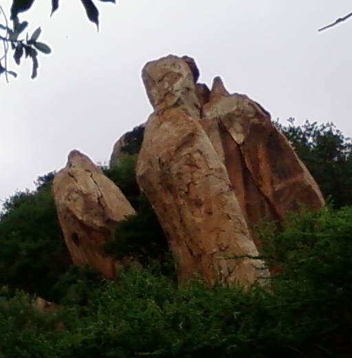
Pillar shaped boulders.
Must involve visitors undertaking some educational task that
relates to the Earth science at the site. This could involve
measuring or estimating the size of some feature or aspect of the
site, collecting and recording data (such as time of a tidal bore),
or sending an e-mail to the cache owner with the answer to Earth
science related questions they obtained by reading an information
display. While photographs may be requested, they do not take the
place of other logging requirements. Taking a photograph alone or
asking people to do internet research does NOT meet these logging
guidelines. Requests for specific content in the photograph (must
include the visitor's face, for example) will be considered an
additional logging requirement and must be optional. Cache owners
may not delete the cache seeker's log based solely on optional
tasks.
To Log your earthcache find, please do the
following (answers by email please, not in your log): You can go
ahead and log your find then email the answers to me within 7 days,
if not your log will be deleted.
Click on hennieventer top of the page and Send
Message
Questions:
1. When stand at coordinates. Look at the boulder in front of
you.
Is the grains small (cooled quickly) or big grains (cooled
slowly)?
2. Looking at this boulder texture. How do you observed the
weathering process happen?
3. Looking at the outcrop (big koppie). How do the trees
manage
to grow on this granite outcrop?
4. What is the “filling” caused by weathering
around
the koppie (outcrop) called?
5. When you examine the pillar shape boulders, what
according
your understanding in time with weathering will happen to
these
boulders?
6. Take a photo of yourself with GPS in front of koppie.
I have used sources available to me by visiting the site using
the
Bakoni Malapa book on the Museum (Jacques Jordaan), the
library,
internet, research, and asking questions to get information
for
this earth cache.
I am not a geologist. Since Earth caching is educational I
also
leant a lot through Earth caching .