Lewis & Clark C&D Trail Multi-Cache
-
Difficulty:
-

-
Terrain:
-

Size:  (regular)
Please note Use of geocaching.com services is subject to the terms and conditions
in our disclaimer.
Welcome to the Couples and Duo's Multi cache run. PLEASE READ THE RULES AND FOLLOW THEM! This run is located along the Baldwin Rail Trail. Please follow ALL park rules while on the trail.
Rules:
1. Please be respectful of other people using the Baldwin Rail Trail. This is a busy trail used by runners, walkers and Bicyclists.
2. Pull your bicycle off of the trail completely when searching for geocaches.
3. LOOK BOTH WAYS BEFORE CROSSING THE TRAIL! Bicylists travel on the the trail at speeds up to 20mph! (TREAT IT LIKE AUTOMOBILE TRAFFIC!)
4. Obey all traffic signs while on the trail. The trail crosses roads open to motor vehicles. Please be carefull and safe.
5. As always, Please be a good representive of the Geocaching community. Be respectfull of other people and their property while geocaching. Remeber that playing our game should be considered privilege not a right.
6. ABSOLUTELY NO MOTORIZED VEHICLES ARE TO BE USED ON ANY PART OF THE BALDWIN RAIL TRAIL!
Tips:
It is highly recomended that you use a bicycle when searching for the C&D multi Trail caches. Some of the caches will require walking through shallow puddles or low lying creeks.
Bring plenty of water and protection from the elements.
The hint on the cache page is for stage one. Hints for stage two will be provided at stage one.
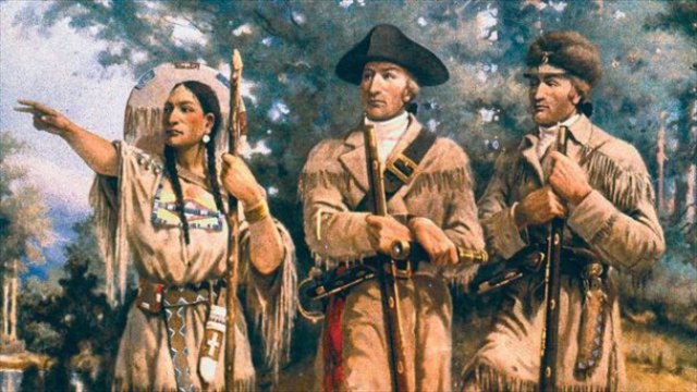 President Thomas Jefferson commissioned the expedition shortly after the Louisiana Purchase in 1803. It comprised a selected group of U.S. Army volunteers under the command of Captain Meriwether Lewis and his close friend, Second Lieutenant William Clark. Their perilous journey lasted from May 1804 to September 1806. The primary objective was to explore and to map the newly acquired territory, to find a practical route across the western half of the continent, and to establish an American presence in this territory before Britain and other European powers tried to claim it. The campaign's secondary objectives were scientific and economic: to study the area's plants, animal life, and geography, and to establish trade with local Native American tribes. With maps, sketches, and journals in hand, the expedition returned to St. Louis to report its findings to Jefferson.
Additional Hints
(Decrypt)
Fznyy Gerr uvtu