It is not a long hike to reach this cache. From the Connifer Road trailhead, I walked less than a mile (and even then there were shortcuts that could have been taken). But there is a sense of isolation as one looks over some of the most remote areas in all of Marin.
There is limited parking at the end of the unpaved Connifer Road in Woodacre, near where it meets Carson Road. I took the paved Carson Rd and drove to the end of Conifer, just enough room to avoid an eroded section of the road in my Prius. From there, the trail climbs through a grove of oaks, bays, and fir until it enters grassland. The views start to open -- Black Mountain, Barnabe, Big Rock Ridge, and (on a clear day) Mt. St. Helena. This part of the trail is about 3/4 mile and climbs 500 feet.
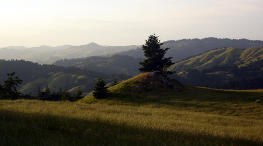
As you reach the top of the San Geronimo Ridge, you may notice "pygmy forests" of dwarf Sargent Cypress trees. Carson Meadow opens up and leads to views of the Big Carson country -- there are no trails through there, so the area near the cache provides a good place to look out over the lands.
The best trail to the cache is a short distance from the junction at Connifer Road, just up the ridge road. For longer hikes, one can continue up to Icarus Touches the Wind or follow the road across to Ridges and Ocean Without End.
There is no need to wade through the bushes in order to find the cache.
If you are meeting people for this hike, it is best to carpool from Woodacre or the San Geronimo Cultural Center. For more information, see the map of the Giacomini Open Space Preserve.