Erosion
Erosion is the process by which soil and rock are removed from the Earth's surface by natural processes such as wind or water flow, and then transported and deposited in other locations.
In this particular area at GZ, Water has caused most of the Erosion here. Springs are both caused by erosion and causes of erosion.
Types of Erosion:
Splash Erosion: Small soil particles are detached and sent airborne through the impact of raindrops on soil.
Sheet Erosion: Raindrops break apart the soil structure and it's moved down-slope by water that flows overland as a sheet rather than definitive channels. This occurs frequently during cloud bursts.
Rill Erosion: This process develops small, short-lived, concentrated flow paths. These paths create a sediment source and delivery system for hill-slope erosion. Areas where precipitation rates exceed soil infiltration rates are more prone to this type of erosion.
Gully Erosion: Water flows in narrow channels during or directly following heavy rains or melting snow. The gullies can erode to considerable depths.
Valley or Stream Erosion: Continual water flow alongside land (along a linear feature) creates this type of erosion. It extends downward, deepening a valley, and head-ward, extending the valley into the hillside. This occurs most frequently in times of flooding.
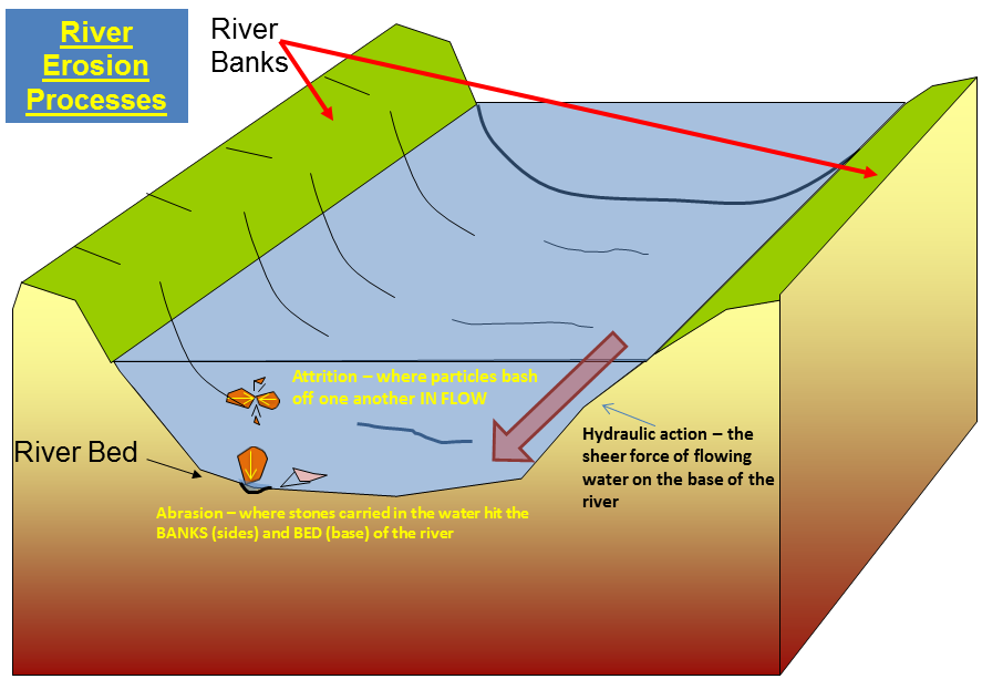
Bank Erosion: Over time, banks of rivers and streams are naturally worn down.
Freezing and thawing: Cold weather causes water trapped in tiny rock cracks to freeze and expand, breaking the rock into several pieces.
Deposits
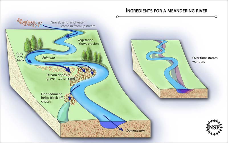
As rivers carry dust, pebbles, and rocks downstream, this material is eventually deposited at some locations further down. These deposits form at bends in a river, as well as in locations where rivers dump water into lakes.
**Logging requirements**
DO NOT POST ANSWERS IN YOUR LOG.
Send the following answers to me via email.
- The text "GC55RBQ Flood Erosion Control of Heartwell Park" on the first line
- At Waypoint “channeled walls” what do the walls look like, (sand bags, straight walls, or rocks)
- What effect does this kind of channel wall have on the way the water flows? (i.e. slows it down, speeds it up)
- As you walk along the channeled wall does the channel seem to be fairly straight or does it curve around and or twists like a snake?
- Do you see any sediment buildup in the channel?
- At either the west or east waypoint “un-channeled” what makes up the creek bed?
- At waypoint “year” what year was this park with its channel “created”?
| I have earned GSA's highest level: |
 |