
Cordillera Huayhuash
Bienvenido a una caminata de varios días a través de la Cordillera Huayhuash. Esto requiere una cierta aptitud física, así como la aclimatación previa. La alta calificación D / T proviene de la necesaria aclimatación, el aislamiento y la enorme altura en la que se encuentra. Inmediatamente, los problemas con el mal de altura no son infrecuentes y deben ser tomados seriamente.
La caminata por lo general tarda entre 8-10 días y pasa pasa entre 4.600 y 5.000 metros. Los caminos suelen ser buenos para encontrar y con un mapa útil (fuera de línea) debe ser difícil perderse. También hay tours ofrecidos con guía, alojamiento (tienda / saco de dormir) y comida. En mi propia gira, encontré el conocimiento, que las guías transmitían con respecto a la geología, como bastante inadecuado. Por lo tanto, esta serie de Earthcaches, que se supone para transmitir algunos conocimientos adicionales. Tenga en cuenta que para registrar la caché es absolutamente necesario hacer ciertas tareas! No es suficiente estar allí.
La serie consta de los siguientes siete Earthcaches y un traditional:
Si resuelve satisfactoriamente uno o más cachés, puede incluir el primer banner en su perfil. Si resuelves todo, puedes incluir el segundo banner. Los banners y el código se pueden encontrar al final de la página.
Vulcanismo
 Además de la caliza ya mencionada, hay volcanismo aquí, como en muchos otros lugares a lo largo del anillo de fuego. Cerca del Paso Paso las señales en la roca son las más visibles.
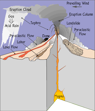
Varias rocas volcánicas se pueden encontrar en el sitio. Entre otras cosas, la toba lítica. Esta es una roca sedimentaria volcánica. En la erupción de un volcán, las cantidades variables de la roca se soplan hacia fuera, dependiendo de la explosividad. Ésta consiste en el magma y la roca, llevados adelante en su manera a la superficie. Esta roca y cenizas se depositan cerca del volcán. Esto puede hacerse por simple caída o por flujos piroclásticos. El calor resultante hace que los componentes se fundan juntos. Lo crea la toba. Dependiendo de la composición, esto puede tener descripciones más detalladas. La toba lítica tiene muchas rocas grandes de la roca circundante.
Puesto que estos componentes no han sido erosionados y por lo tanto han sido de forma redonda y son bastante angulares, esto no se llama conglomerado, sino brecha.
Tarea
Siga este procedimiento:
- ¡Lea el Earthcache y las preguntas!
- Vaya al lugar y busque respuestas.
- Envíame las respuestas.
- Posteriormente puede iniciar sesión inmediatamente.
Por favor, hágalo en este orden. :-)
- En las coordenadas encontrarás en la toba lítica del suelo. Realizar una investigación sobre una piedra utilizable: superficie, distribución de roca extraña, porcentaje de roca extraña, color de la roca extraña (principalmente), color de la masa de relleno.
- De la observación es la roca un conglomerado o una brecha?
- ¿La apariencia de la roca coincide con el proceso de formación? Describa por qué.

Cordillera Huayhuash
Welcome to a multi-day hike through the Cordillera Huayhuash. This requires a certain physical fitness as well as previous acclimatization. The high D / T rating comes from the necessary acclimatization, the seclusion and the enormous height in which you are located. Immediately, problems with altitude sickness are not uncommon and should be taken seriously.
The hike usually takes between 8-10 days and passes passes between 4,600 and 5,000 meters. The paths are usually good to find and with a useful (offline) map it should be difficult to get lost. There are also tours offered with guide, accommodation (tent / sleeping bag) and food. In my own tour, I found the knowledge, which the guides conveyed with regard to the geology, as rather inadequate. Therefore, this series of Earthcaches, which is supposed to convey some additional knowledge. Please note that in order to log the cache it is absolutely necessary to do certain tasks! It is not enough to be there.
The series consists of the following seven Earthcaches and one traditional:
If you successfully solve one or more caches, you can include the first banner in your profile. If you solve all, you can include the second banner. The banners and the code can be found at the end of the page.
Vulcanism
In addition to the already mentioned limestone, there is volcanism here, as in many other places along the fire ring. Near the Paso Pass the signs in the rock are the most visible.
Various volcanic rocks can be found on site. Among other things, lithic tuff. This is a volcanic sedimentary rock. In the eruption of a volcano, varying amounts of rock are blown out, depending on the explosiveness. This consists of the magma and the rock, carried along on its way to the surface. This rock and ashes are deposited near the volcano. This can be done by simply dropping down or by pyroclastic flows. The resulting heat causes the components to melt together. This results in tuff. Depending on the composition, this may have more detailed descriptions. Lithic tuff has a lot of large rocks from surrounding rock.
Since these components have not been eroded and so have been round-shaped and are rather angular, this is not called conglomerate, but breccia.
Task
Please follow this procedure:
- Read the Earthcache and the questions!
- Go to the place and look for answers.
- Send me the answers.
- Afterwards you can immediately log.
Please do it in this order. ;-)
- At the coordinates you will find on the ground lithic tuff. Perform an investigation on a usable stone: surface, distribution of extraneous rock, percentage of extraneous rock, color of extraneous rock (mainly), color of filling mass.
- From observation is the rock a conglomerate or a breccia?
- Does the appearance of the rock match the process of formation? Describe why.

Cordillera Huayhuash
Willkommen auf einer mehrtägigen Wanderung durch die Cordillera Huayhuash. Diese setzt eine gewisse körperliche Fitness sowie vorherige Akklimatisation voraus. Die hohe D/T Wertung kommt von der nötigen Akklimatisierung, der Abgeschiedenheit und der enormen Höhe, in der ihr euch befindet. Gleich vorweg, Probleme mit der Höhenkrankheit sind nicht selten und sollten ernst genommen werden.
Die Wanderung dauert normalerweise zwischen 8-10 Tage und überschreitet Pässe zwischen 4.600 und 5.000 Metern. Die Wege sind in der Regel gut zu finden und mit einer brauchbaren (offline-)Karte sollte es schwer werden, sich zu verirren. Es werden auch Touren angeboten mit Guide, Unterkunft (Zelt/Schlafsack) und Essen. In meiner eigenen Tour empfand ich das Wissen, welches die Guides vermittelten in Bezug auf die Geologie, als eher unzureichend. Daher diese Serie von Earthcaches, die etwas zusätzliches Wissen vermitteln soll. Bitte beachte dabei, dass es durchaus nötig ist, ein den spezifischen Stellen Aufgaben zu erfüllen! Es reicht in der Regel nicht, nur da gewesen zu sein.
Die Serie besteht aus den folgenden sieben Earthcaches und einen Tradi:
Wer erfolgreich einen oder mehrere Caches löst, kann den ersten Banner in sein Profil einbinden, wer alle löst, kann den zweiten Banner einbinden. Die Banner und der Code sind am Ende der Seite zu finden.
Vulkanismus
Neben dem bereits erwähnten Kalkstein, gibt es, wie auch an vielen anderen Orten entlang des Feuerrings, Vulkanismus. Nahe dem Paso Pass sind die Zeichen im Gestein am präsentesten.
Vor Ort lassen sich verschiedene vulkanische Gesteine finden. Unter anderem lithischer Tuff. Hierbei handelt es sich um ein vulkanisches Sediment Gestein. Beim Ausbruch eines Vulkans werden, je nach Explosivität, unterschiedliche Mengen Gestein ausgeschmissen. Dies besteht aus dem Magma und dem, auf dem Weg zur Oberfläche, mitgerissenem Gestein. Dieses Gestein und Asche lagert sich nahe dem Vulkan ab. Dies kann durch einfaches Herunterfallen geschehen oder durch pyroklastische Ströme. Die dabei vorkommende Hitze lässt die Bestandteile miteinander verschmelzen. Daraus resultiert Tuff. Je nach Zusammensetzung kann dieser weitergehende, genauere Beschreibungen haben. Lithischer Tuff hat dabei besonders viele größere Gesteinsanteile aus umliegendem Gestein.
Da diese Bestandteile nicht durch Erosion abgeschliffen und rund geformt wurden und eher eckig vorliegen, wird dieses nicht Konglomerat, sondern Brekzie genannt.
Fragen
Bitte wie folgt Vorgehen:
- Lese den Earthcache und die Fragen!
- Gehen zum Ort und suche nach den Antworten.
- Schicke mir die Antworten
- Im Anschluss kann direkt geloggt werden.
Bitte in dieser Reihenfolge ;-)
- An den Koordinaten wirst du auf dem Boden lithischen Tuff finden. Führe eine Untersuchung an einem brauchbaren Stein durch: Oberfläche, Verteilung des Fremdgesteins, Anteil des Fremdgesteins, Farbe des Fremdgesteins (hauptsächlich), Farbe der Füllmasse.
- Von der Beobachtung ist das Gestein ein Konglomerat oder eine Brekzie?
- Passt das Aussehen des Gesteins zu dem Entstehungsprozess? Beschreibe warum.
Banner & PDF
4 or more:
<a href="https://coord.info/GC79C75"><img src="https://abload.de/img/echuyhuashminfin1zsk5x.png" alt="Banner Earthcache Huayhuash" width="300" /></a>
all 8:
<a href="https://coord.info/GC79C75"><img src="https://abload.de/img/echuyhuashfin1wzju7.png" alt="Banner Earthcache Huayhuash" width="300" /></a>
|
Alle Geocaches in einer PDF:

|
All Geocaches in one PDF:
|
Todos los Geocaches en un PDF:
|