Meluzína (Eklogit, Eclogite)
I would first like to thank the5013thing for his helpful support and the excellent co-operation. I appreciate your assistance!
Geologie / Geology / Geologie (Obrázek č.1 / Figure 1 / Abbildung 1)
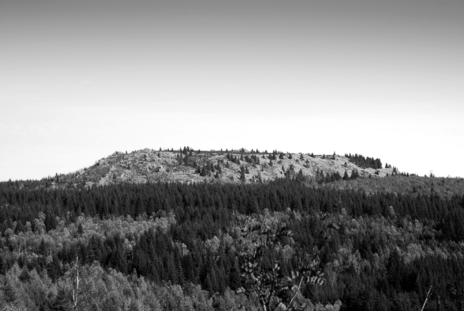
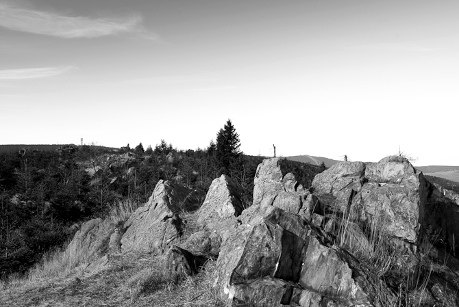
Hora Meluzína (Wirbelstein, obrázek č. 2), která se nachází přibližně 3 km východně od Klínovce, se tyčí asi 40 metrů nad okolní mírně zvlněný terén Krušných hor. Na jejích svazích a na 750 m dlouhé a 250 m široké vrcholové plošině se nachází mnoho skalních útvarů a balvanů (obrázek č. 3,4). Z vrcholu Meluzíny je patrný rozdíl mezi německou mírně svažitou stranou hor a strmými svahy podél Krušnohorského zlomu na straně české.
Dominující horninou Meluzíny je eklogit – silně přeměněná hornina, která vznikla v devonu během Hercynského vrásnění. Při přibližování dvou kontinentů – Gondwany a Laurasie – docházelo k subdukci (podsouvání) mezi nimi ležící oceánské kůry. Podmořské vulkány chrlily materiál (bazalt), který se ukládal na mořském dně. Při podsouvání oceánské kůry se tento bazalt dostával stále do větších hloubek, kde byl za vysokých tlakových a teplotních podmínek přeměňován na eklogit a to v hloubkách do 40 km. V karbonu došlo ke kolizi obou kontinentů a tím byla zastavena i subdukce oceánské kůry. Kůra se deformovala a došlo k vrásnění, při čemž vzniklo Hercynské pohoří. Eklogit byl rozlámán na části a ty byly vyzdviženy s okolními ortorulami. V následujícím období, až do konce permu, podléhalo Hercynské pohoří silné erozi a eklogit byl exponován na zemském povrchu. V třetihorách, během alpinského vrásnění, došlo vlivem enormního tlaku k rozlámání staré kůry a k uklonění krušnohorské desky podél zlomu k severozápadu. Říční eroze se zároveň postarala o vyhloubení horských údolí. Masivní eklogity jsou vůči zvětrávání mnohem odolnější než okolní ortoruly. To způsobilo selektivní vyvětrání eklogitů, které se vynořují z ortorul v podobě nápadného hřbetu Meluzíny.
(Devon: 408 mil. let až 360 mil. let; Karbon: 360 mil. let až 286 mil. let, Perm: 286 mil. let až 248 mil. let)
ENGLISH
The prominent mountain Meluzína (Wirbelstein, Figure 2) is located approximately 3km east of Klínovec (Keilberg). It soars about 40ms from the moderately undulating terrain of the Ore Mountains. There are numerous rocks and boulders on its slopes and on the 750ms long and 250ms wide summit plateau (Figure 3,4). On top of Meluzína you can see the typical character of the half-horst with its steep scarp face toward Bohemia in the south and a gentle slope on the German side in the north.
Meluzína consists of the highly metamorphosed (transformed) rock eclogite which was built during the Variscan orogeny (mountain building) in Devon. At the beginning the space between the towards moving continents Gondwana and Laurussia gets closer, came along with subduction of oceanic crust. Submarine volcanoes deposited their material (basalt) at the seabed. By the ongoing subduction, the ocean basalts got more and more into the depth and were metamorphosed by higher pressure and temperature to eclogite in 40ms depth. In Carboniferous, after the collision of the continent blocks, the subduction came to a standstill. Rocks were deformed, stacked and folded to the Variscan Mountains. The deep recessed eclogite broke and was transported upwards in smaller lenses along with the surrounding rock gneiss. In the following period, the Variscan mountains were eroded by strong erosion until the end of the Permian. The eclogite was exposed. Much later, during Tertiary, the mountain remnants came under heavy pressure as a result of plate tectonic processes during which the Alps were formed. The rock of the Ore Mountains shattered into an independent fault block which was uplifted and tilted to the northwest. Over time, the erosion formed deep valleys and mountain ranges into the former plateau. The massive rock eclogite weathered only selective why Meluzína is a characteristic mountain ridge today.
(Devonian: 408-360 mya; Carboniferous: 360-286 mya, Permian: 286-248 mya)
DEUTSCH
Der morphologisch auffällige Meluzína (Wirbelstein, Abbildung 2) befindet sich ca. 3km östlich vom Klínovec (Keilberg). Er erhebt sich ungefähr 40m aus dem mäßig gewellten Gelände der Erzgebirgslandschaft. An seinen Hängen und auf dem etwa 700m langen und 250m breiten Gipfelplatau findet man zahlreiche Felsen und Felsblöcke (Abbildung 3,4). Am Gipfel des Meluzína gewinnt man einen Eindruck vom typischen Charakter der Pultscholle mit dem Steilabfall nach Süden und der flachen Nordabdachung.
Der Meluzína besteht aus dem stark metamorphen (umgewandelten) Gestein Eklogit, welches im Zuge der Variszischen Orogenese (Gebirgsbildung) im Devon entstanden ist. Dabei wurde in der Anfangsphase der Raum zwischen den sich aufeinander zu bewegenden Kontinenten Gondwana und Laurussia immer enger, was mit Subduktion (Unterschiebung) von zwischengelagerter ozeanischer Kruste einherging. Untermeerische Vulkane lagerten ihr Material (Basalt) im marinen Rau ab. Durch die anhaltende Subduktion gerieten diese Ozeanbasalte immer weiter in die Tiefe und wurden bei den dort herrschenden höheren Druck- und Temperaturbedingungen in ca. 40km Tiefe zu Eklogit metamorphisiert. Im weiteren Verlauf kam es im Karbon zur Kollision der Kontinentblöcke, wobei Subduktionsprozesse zum Erliegen kamen. Gesteine wurden deformiert, übereinander gestapelt und zum Variszischen Gebirge aufgefaltet. Der tief versenkte Eklogit zerbrach und wurde in kleineren Linsen mit den benachbarten Gneisen nach oben transportiert. Im folgenden Zeitraum wurde das Variszische Gebirge durch starke Erosion bis zum Ende des Perm wieder abgetragen und der Eklogit wurde freigelegt. Viel später, im Tertiär, kam es im Zuge der Alpidischen Orogenese durch enormen Druck zum Zerbrechen der alten Gesteinsplatten und die Erzgebirgsbruchscholle wurde nach Norden angekippt, der Egergraben im Süden eingesenkt. Im Laufe der Zeit modellierte die Erosion aus der ehemaligen Ebene tiefe Täler und Höhenrücken heraus (Zertalung). Die massiven Eklogite verwitterten nur selktiv, weshalb der Meluzína heute einen charakterisitschen Bergrücken darstellt.
(Devon: vor ca. 408–360 Mio. Jahren; Karbon: vor ca. 360–286 Mio. Jahren; Perm: vor ca. 286–248 Mio. Jahren)
Úkoly / Tasks / Aufgaben
Zalogujte se a pošlete nám odpovědi na otázky č. 1 a 2 přes profil nebo na e-mail teamanuto@gmail.com! Pokud odpovědi nebudou správné, budeme vás kontaktovat. K logu (ne mailem) můžete připojit i fotografii vás nebo krajiny u Meluzíny, není to však podmínkou.
Please log your visit and send us the answers to question 1 and 2 via profile or by mail (teamanuto@gmail.com)! We will contact you if the answers are not correct! A photo of you or the landscape in your log (not in the mail!) would be nice.
Schreibt uns bitte über unser GC-Profil oder per Mail (teamanuto@gmail.com) die Antworten zu Aufgabe 1 und 2! Ihr könnt nach der Einsendung der Antworten sofort loggen! Wir melden uns, wenn etwas nicht stimmt! Ein Foto von euch oder der Landschaft in eurem Log (nicht in der Mail!) ist kein Muss, wäre aber schön.
1. Úkol (hornina "M") - N 50° 23.449 E 013° 00.411 (spoiler)
a.) Popište eklogit na vrcholu Meluzíny (barvu, texturu a strukturu).
b.) Posuďte odolnost eklogitu vůči svému prostředí.
1. Task (rock "M") - N 50° 23.449 E 013° 00.411 (spoiler)
a.) Describes the eclogite at the summit of Meluzína (color, structure, texture)!
b.) What do you think is the resistance of the rock to environmental influences?
1. Aufgabe (Gestein "M") - N 50° 23.449 E 013° 00.411 (Spoiler)
a.) Beschreibt den Eklogit am Gipfel des Meluzína (Farbe, Struktur, Textur)!
b.) Wie schätzt ihr die Beständigkeit des Gesteins gegenüber Umwelteinflüssen ein?
2. Úkol (měření) - N 50° 23.451 E 013° 00.449
Listingové souřadnice vás zavedou k trigonometrickému bodu (spoiler) na Meluzíně. Novější měření zjistila, že se nejvyšší místo nachází na jedné výrazné skále. Zkuste se po ní z místa souřadnic porozhlédnout (spoiler).
a.) Jakým směrem (ve stupních) se nachází nejvyšší skála Meluzíny od trigonometrického bodu?
b.) Odhadněte, o kolik metrů je nejvyšší skála vyšší než trigonometrický bod (cca. 3m, 7m, 12m).
2. Task (survey) - N 50° 23.451 E 013° 00.449
At the listing coordinates you are at the survey point (spoiler) of Meluzína. Recent surveys showed, that the highest point of the mountain is located on a prominent rock. Look for the summit rock (spoiler) at the listing coordinates!
a.) In which direction (degrees) is the summit rock from the survey point?
b.) Estimate how many meters the summit rock is higher than the survey point (about 3m, 7m, 12m?)!
2. Aufgabe (Vermessung) - N 50° 23.451 E 013° 00.449
An den Listing-Koordinaten befindet ihr euch am Vermessungspunkt (Spoiler) des Meluzína. Neuere Vermessungen haben aber ergeben, dass sich die höchste Stelle des Berges auf einem markanten Felsen befindet. Haltet an den Listing-Koordinaten Ausschau nach dem eigentlichen Gipfelfelsen (Spoiler)!
a.) In welcher Richtung (Grad) befindet er sich vom Vermessungspunkt aus?
b.) Schätzt ein, um wieviel Meter der Gipfelfelsen höher ist als Vermessungspunkt (ca. 3m, 7m,12m?)!
Přejeme příjemnou zábavu! Have Fun! Wir wünschen viel Spass:)
Sever / North / Norden > Bärenstein (898m), Pöhlberg (831m), Loučná (Weißes Kreuz, 1119m)
Severovýchod / Northeast / Nordosten > Velký Špičák (Großer Spitzberg, 965m), Jelení hora (Hassberg, 994m)
Severozápad / Northwest / Nordwesten > Klinovec (Keilberg, 1244m), Macecha (1113m), Fichtelberg (1215m), Eisenberg (1028m)


Obrázek č.1 / Figure 1 / Abbildung 1: Vznik Meluzíny / Emergence of Meluzína / Entstehung des Meluzína (©anuto)

Obrázek č.2 / Figure 2 / Abbildung 2: Meluzína (©anuto)
Obrázek č.3 / Figure 3/ Abbildung 3: Skalnatý hřbet / Rocky ridges / Felsrippen (©anuto)
Obrázek č.4 / Figure 4 / Abbildung 4: Skalnatý svah / Rocky slope / Felshang (©anuto)

Zdroje / Sources / Quellen: Diercke.de; Geology.cz; Geologieinfo.de; Klett.de; Wikipedia.cz; Wikipedia.de; Ulrich Sebastian: Die Geologie des Erzgebirges, Springer Spektrum, 2013; Otfried Wagenbreth & Walter Steiner: Geologische Streifzüge, Deutscher Verlag für Grundstoffindustrie, Leipzig 1990; Adolf Hanle: Meyers Naturführer Erzgebirge, Bibliographisches Institut, Mannheim, 1992