Earth Cache "El Dedo de Dios" :
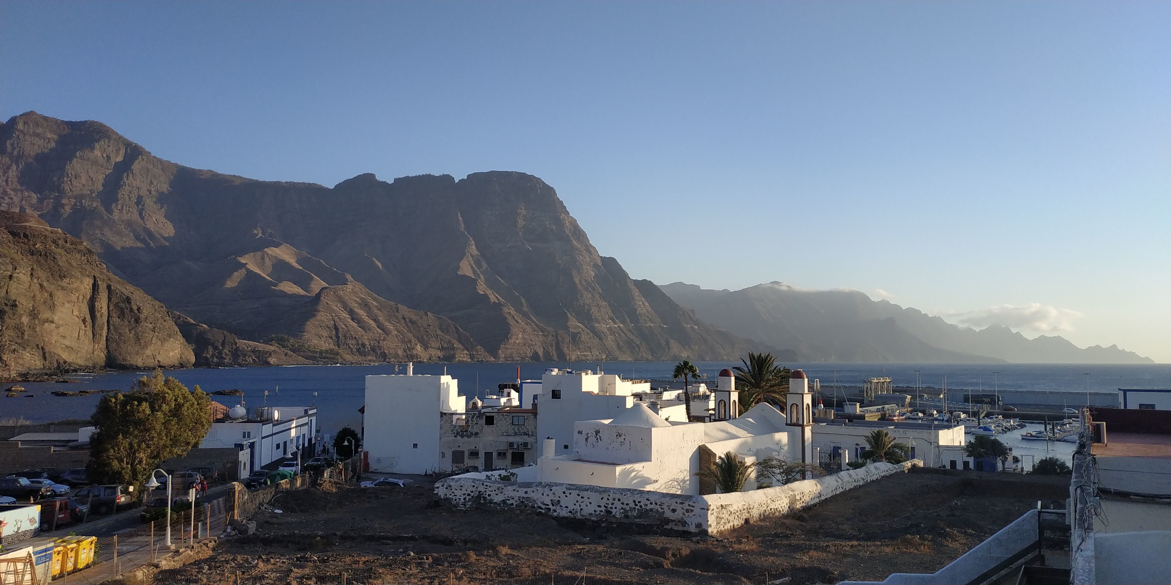
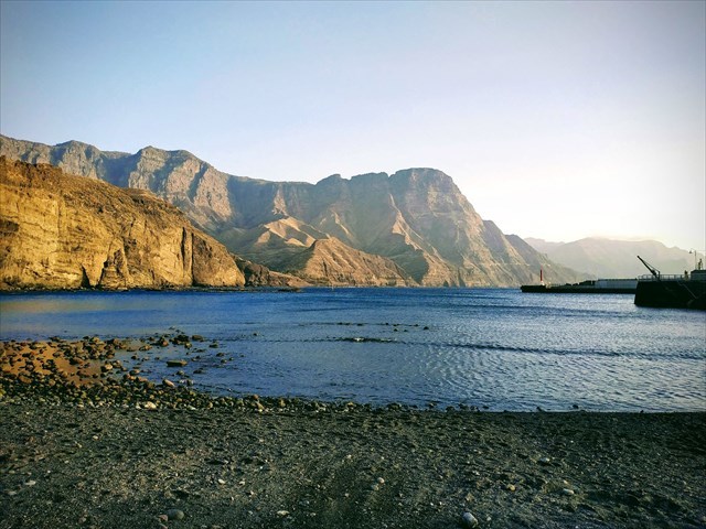
El Dedo de Dios es uno de los grandes iconos de Gran Canaria, y desde luego el icono por antonomasia del municipio de Agaete y su Puerto de las Nieves.
Cada año miles de visitantes pasean por el Muelle Viejo de Agaete, leen los rótulos explicativos, y buscan el "Dedo", que si bien ésta a plena vista, es muy juguetón y le encanta camuflarse con las luces cambiantes, mimetizándose con el acantilado que tiene detrás disimulando de este modo su perfil.
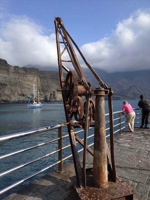
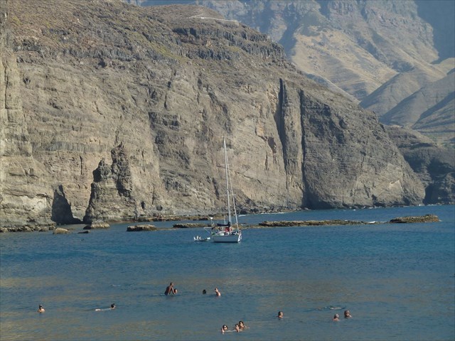
La formación geológica del Roque Partido -su verdadero nombre, ahora más ajustado a la realidad al faltarle su parte superior- está ligada a fenómenos erosivos que han ido haciendo "retroceder" la línea de costa de esta zona, que empezó a formarse hace 14 millones de años.
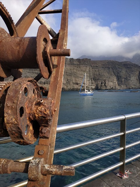
Al ir siendo erosionados los materiales más blandos por el viento y especialmente por el mar, los núcleos basàlticos que resisten mejor la erosión, se mantienen, calculándose en 300.000 años la edad del Roque, que también se ha erosionado por el viento y el batir de las olas, adoptando esa "caprichosa forma".
Como resultado de esa continua erosión natural, a finales de 2005 el "dedo índice" se encontraba en un precario equilibrio, y la tarde del 28 de noviembre de ese año la tormenta tropical "Delta" acabó por derrumbar y hundir bajo el mar unos 6 metros de la parte superior, que hoy en los días de más tranquilo se pueden observar bajo el agua.
Para contemplarlo en su grandioso escenario, el mejor sitio es el Muelle Viejo de Agaete, a la izquierda de la bahía, un paseo por él es una delicia, además de un gran sitio para darse un baño rodeado de vida marina.
Para poder registrar este Earth Cache deberás enviarme a mi correo: fachico57@yahoo.com o bien en un mensaje a mi perfil en Geocaching.com las respuestas a las siguientes preguntas, después puedes registrar la visita, te contestaré si hay algún comentario que hacer a tus respuestas:
1.- ¿De que material volcánico está formado el "Dedo de Dios", cuál fué su proceso de formación y que edad tiene?
2.- ¿Cuando se fracturó y como se llamaba la tormenta que lo hizo?
3.- Mira la contigua playa, observa color y textura de la poca arena y forma y tamaño de las piedras o "bolos", ¿Cual crees que es su orígen y porqué es tan distinta de las playas "claras" del Sur de la Isla?
4.- Como he dicho antes, el "Dedo" se mimetiza con el acantilado que tiene detrás, fíjate que incluso las "vetas" o líneas naturales en la roca se confunden con las del acantilado, ¿cual crees que es la razón?
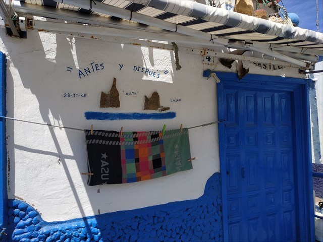
5.- Envíame una fotografía tuya, o de tu mascota, o de tu GPS con coordenadas visibles delante de la curiosa "obra de arte" pintada en la fachada de la casita blanca y azul en el waypoint que señalo y que representa el "antes" y el "dispues" de la tormenta Delta.
INGLÉS:
"El Dedo de Dios" is one of the great icons of Gran Canaria, and of course the icon par excellence of the municipality of Agaete and its Puerto de las Nieves.
Every year thousands of visitors walk along the Old Dock of Agaete, read the official explanatory texts, and look for the "Finger", which although in full view, is very playful and loves to camouflage itself with the changing lights, mimicking the cliff that has behind it and hiding his profile in this way.
The geological formation of the Roque Partido - its real name, now more adjusted to reality when its upper part is lacking - is linked to erosive phenomena that have "pushed back" the coastline of this area, which began to form 14 million ago of years.
As the softer materials are eroded by the wind and especially by the sea, the basaltic cores that resist erosion are better maintained, calculating the age of the Roque in 300,000 years, which has also been eroded by the wind and the beating of the waves, adopting that "capricious form".
As a result of this continuous natural erosion, at the end of 2005 the "index finger" was in a precarious equilibrium, and on the afternoon of November 28 of that year the tropical storm "Delta" ended up collapsing and sinking about 6 meters from the top, which today in the days of quieter sea can be observed underwater.
To contemplate it in its great scenery, the best place is the Agaete Old Pier, to the left of the bay, a walk through it is a delight, as well as a great place to take a bath surrounded by marine life.
To register this Earth Cache you must send me to my email: fachico57@yahoo.com or in a message to my profile on Geocaching.com the answers to the following questions, then you can register the visit, I will answer you if there is any comment to make to your answers:
1.- Which volcanic material is the "Finger of God" formed of, which was its formation proccess and how old is it?
2.- When was it fractured and what was the name of the storm that did it?
3.- Look at the near beach, observe color and texture of the little parcels of sand and the shape and size of the stones or "bolos", what do you think is its origin and why is it so different from the "clear" beaches in the south side of the Island?
4.- As I said before, the "Finger" mimics the cliff behind it, notice that even the "veins" or natural lines in the rock are confused with those of the cliff, what do you think is the reason?
5.- Send me a picture of you, or your pet, or your GPS with visible coordinates in front of the curious "work of art" painted on the facade of the white and blue little house at the waypoint that I indicate and that represents the "before" and the "after" of the Delta storm.