PLEASE NOTE: Your answers must be submitted AND approved by me before you may claim a find. If you claim a find before your answers have been approved, your log WILL BE DELETED. You may rest assured that all answers falling within reasonable tolerances will be approved promptly. If there is an issue with any point, I will be happy to tutor in geology.
Drive the scenic Stevens Canyon Road in Mt. Rainier National Park during its open season and you might pass across one of the Park's most interesting geologic features without realizing it. Box Canyon is a classic example of a slot canyon, created when the inexorable and persistent erosional force of water etched away an intrusive dike of softer material to leave a deep cleft between narrow walls of harder basalt. Pull off into the parking area east of the bridge, walk a short ways on a paved trail, and you will find your chin dropping at the sight of this quiet treasure.
So how did this present spectacle come into existence? It began with a fissure eruption of Mt. Rainier which exuded a very liquid and highly basaltic lava flow. As this flow cooled and solidified, fractures formed within it. A subsequent eruption injected a material of a less basaltic nature into the fractures, forcing them wider apart. The less basaltic flow (a softer material) formed what is known as an intrusive dike, in this case one which lay in an almost perpendicular plane to the harder basalt. Over time, water began to erode the softer material away at a faster rate than the surrounding matrix, making a channel which served as a gutter for runoff. As a greater volume of water flowed through the channel, its erosive strength multiplied until finally we were left with the slot canyon as it is seen today. The dike is no longer in evidence.
Today, the river we know as the Muddy Fork of the Cowlitz flows through this canyon. It begins at the foot of the Cowlitz Glacier and ends when it joins the mainstem Cowlitz at the south foot of Backbone Ridge near Packwood. It drops over 3000' in its journey, and your task is to determine how far it falls in the stretch between the two bridges at Box Canyon.
1) At Waypoint 1 - 46° 45.933 121° 38.143 - (the south bridge at 3050' elevation), you will find a sign giving the distance from the bridge deck to the water below. Record this number for your calculations.
2) At Waypoint 2 - 46° 46.016 121° 38.214 - (the north bridge at 3030' elevation), you will find another sign giving the distance from the bridge deck to the water below. Also record this number for your calculations.
3) Measure the distance (straight line, using your GPSr) between the two waypoints and round to the nearest tenth of a mile (i.e. 0.14 = 0.1 or 0.15 = 0.2).
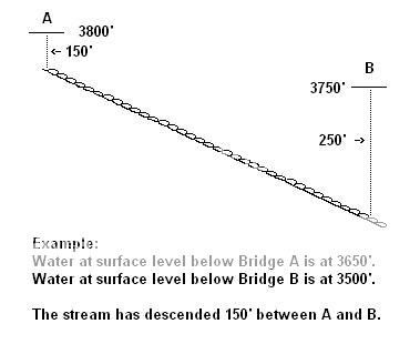
4) Using the method shown in the example diagram below, calculate how many feet the river drops per 0.1 mile at this point.
NOTE: Do not put any of the above information in an on-line log. When you EMAIL your answers to me, please cite all the numbers you obtained on-site, and show ALL MATH used to compute your solution. CORRECT answers are required to log a find.