La Earhcache / The Earhcache
► Contexte géologique local
La partie sud de Brétignolles sur Mer, au niveau du marais Girouard, à une histoire géologique complètement différente des séries métamorphiques de la partie nord.
Nous sommes en présence de deux séries non métamorphisées formant la partie méridionale de la fameuse "série géologique primaire de Brétignolles".
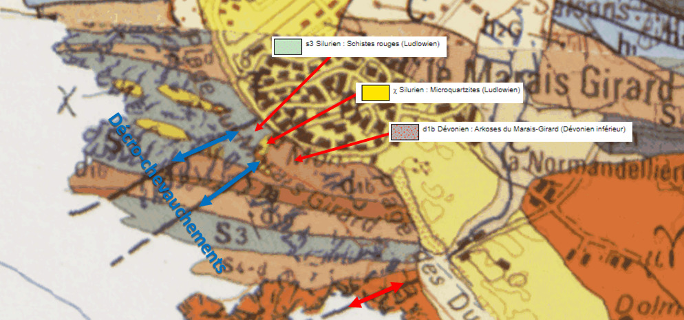
Ces deux formations ont été mises en contact par un histoire tectonique intense, fait de décrochements et d'intrusions qui ont fortement remaniés leur zone de rencontre.
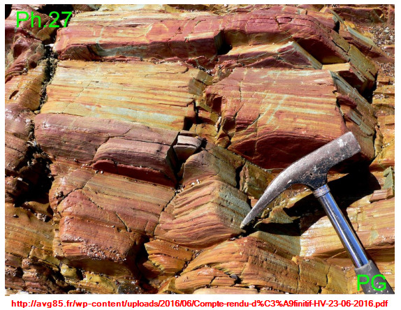
► Les Schistes bariolés de la Parée
Contrairement à ce que précise la carte géologique, les schistes détritiques sédimentaires bariolées de la Parée se sont déposées dans un fossé tectonique du début au Carbonifère (-360 Ma).
Ce sont des formations d’argilo-siltites versicolores peu consolidées constitués de poudre de quartz avec de fins débris de mica et de granules ferrugineux.
L'oxydation du fer de ces granules leur donne une coloration bariolée (jaune, rouge, violacé)
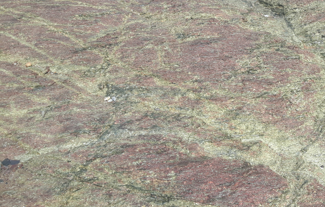
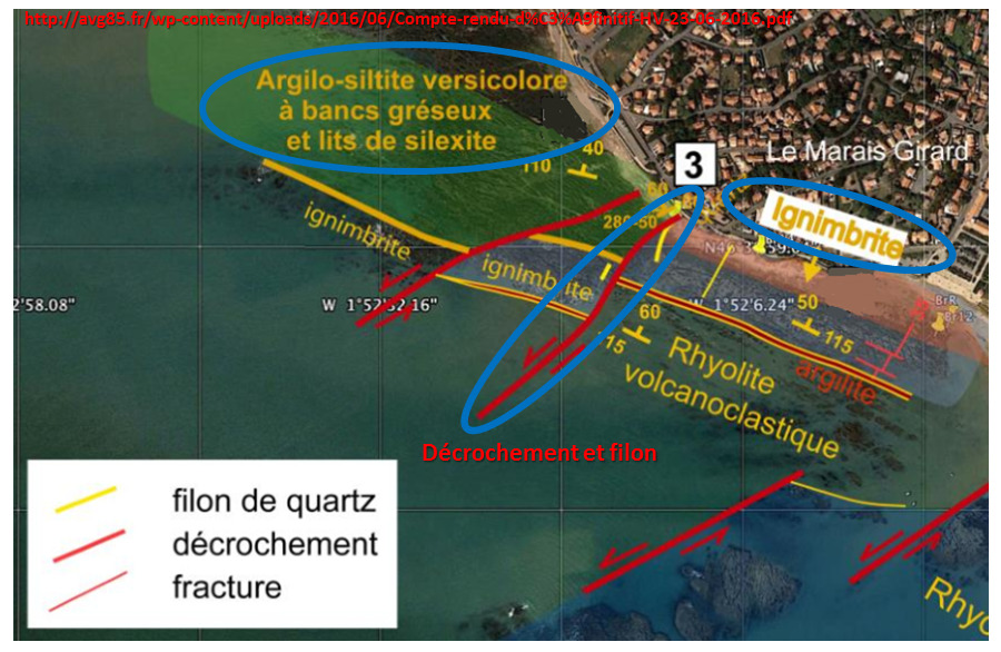
► L'Ignimbrite du Marais Girard
Le fossé contenant les dépôts de schistes bariolés a été recouvert au Viséen par une formation volcanique de l’Unité de La Chapelle-Hermier (-346 Ma).
Cet épisode volcanique continental a vu la mise en place d'ignimbrite, une formation de brèches volcaniques soudées à chaud résultant d’un écoulement pyroclastique de type nuée ardente.
Cette ignimbrite a la même composition chimique que les laves de rhyolites qu'elle chevauche.
Les variations de couleur rouge et verte résultent de différents taux d’oxydation du fer qui diffuse le long des plans de fracture.
Ces formations sont massives et ne présentent pas de litage orienté comme les schistes bariolés.
Ces ignimbrites ont été transportées vers l’ouest sur quelques dizaines de kilomètres lors de la mise en place des massifs granitiques de La Roche-sur-Yon pour se retrouver en contact avec les argilites carbonifères.
► Décrochements et roches filoniennes
Un important phénomène tectonique du cycle orogénique hercynien (mise en place d'une chaîne de montagne) a provoqué un décrochement majeur il y a 320 Ma de direction Sud-Ouest.
Les schistes bariolés de la Parée sont venus au contact de l'ignimbrite du Marais Girard par ce décrochement au niveau de failles inverses parallèles entre elles.
Plusieurs phénomènes se sont alors produits dans cette zone de mouvement tectonique :
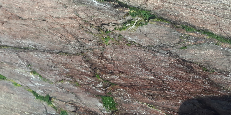
- Un écrasement et un mélange des formations au contact :
Sur quelques mètres de part et d'autre du chevauchement, les formations volcaniques et sédimentaires ont été fortement comprimées et broyées, montrant la violence de ce contact tectonique.
Les deux formations se sont mélangées (strates sédimentaires intriquées d’écailles d’ignimbrites).
- La zone de de fracturation est injectée par un gros filon de pegmatite hydrothermal (roche monocristalline de quartz opaque et de couleur blanc brillant). Ce filon est penché à 60° et positionné en partie dans le décrochement puis s'enfonce dans l’ignimbrite.

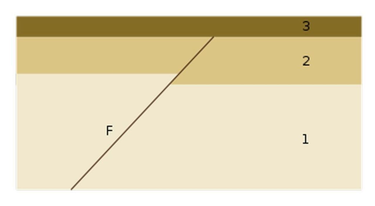
► Principe de datation géologique
Il existe plusieurs type de datation relative des roches et événements géologiques.
L'un d'entre eux est le principe de recoupement : Un événement (intrusion magmatique, faille, plissement, discordance, érosion) qui provoque un changement dans la géométrie des roches est postérieur à la dernière strate qu'il affecte et antérieur à la première strate non affectée.
Autrement dit, tout événement géologique qui en recoupe un autre lui est postérieur.
Dans l’exemple ci-dessous, le filon F est postérieur aux strates 1 et 2, mais antérieure à la strate 3.
► Local geological context
The southern part of Brétignolles sur Mer, at the level of the Girouard marsh, has a geological history completely different from the metamorphic series of the northern part.
We are in the presence of two non-metamorphosed series forming the southern part of the famous "primary geological series of Brétignolles".
These two formations have been brought into contact by an intense tectonic history, made of setbacks and intrusions that have greatly altered their meeting area.
► The variegated schists of Parée
Contrary to what is specified in the geological map, the variegated sedimentary detrital shales of the Parée are deposited in a tectonic ditch from the beginning to the Carboniferous (-360 Ma).
These are loosely consolidated, multi-colored clay-silt formations made of quartz powder with fine debris of mica and ferruginous granules.
The oxidation of the iron in these granules gives them a variegated coloration (yellow, red, purplish)
► The Ignimbrite du Marais Girard
The ditch containing the variegated shale deposits was covered in Viséen by a volcanic formation of the Unit of La Chapelle-Hermier (-346 Ma).
This continental volcanic episode saw the establishment of ignimbrite, a formation of hot welded volcanic breccias resulting from a pyroclastic flow of the fiery cloud type.
This ignimbrite has the same chemical composition as the rhyolite lavas it overlaps.
The red and green color variations result from different rates of oxidation of the iron, which diffuses along the fracture planes.
These formations are massive and do not have any oriented bedding like the variegated shales.
These ignimbrites were transported to the west over a few tens of kilometers during the establishment of the La Roche-sur-Yon granite massifs to find themselves in contact with the carboniferous argillites.
► Recesses and vein rocks
An important tectonic phenomenon of the Hercynian orogenic cycle (establishment of a mountain range) caused a major setback 320 million years ago in the southwest direction.
The variegated shales of the Parée came into contact with the ignimbrite of the Marais Girard by this setback at the level of reverse faults parallel to each other.
Several phenomena then occurred in this zone of tectonic movement:
- A crushing and a mixture of contact formation:
Over a few meters on either side of the overlap, the volcanic and sedimentary formations were strongly compressed and crushed, showing the violence of this tectonic contact.
The two formations mixed (entangled sedimentary strata of ignimbrite scales).
- The fracturing zone is injected by a large vein of hydrothermal pegmatite (monocritalline rock of opaque quartz and bright white in color). This vein is tilted at 60 ° and partly positioned in the recess and then sinks into the ignimbrite.
► Principle of geological dating
There are several types of relative dating of rocks and geological events.
One of them is the principle of overlap: An event (magmatic intrusion, fault, folding, discordance, erosion) which causes a change in the geometry of the rocks is after the last stratum which it affects and before the first stratum not affected.
In other words, any geological event which overlaps another one is subsequent to it.
In the example below, vein F is posterior to strata 1 and 2, but anterior to stratum 3.
► Sources bibliographiques / Bibliographical sources
Les Questions / The Questions
Questions pour valider :"Décrochements et Intrusions au Marais Girard"
Questions to validate: "Dropouts and Intrusions at the Girard Marsh"
!!! ATTENTION A LA MAREE !!!
!!! WARNING TO THE TIDE !!!
Avant de vous y aventurer, consulter l'horaire des marées :
Before you go, check the tide schedule:
Horaires des marées pour Bretignolles-sur-Mer.
- Question 0 : Prenez une photo de vous ou d'un élément vous identifiant avec l'estran en arrière plan (mais pas le waypoint).
Cette photo devra au choix nous être transmise avec les réponses ou être ajoutée à votre log.
-Question 0 : - Question 0: Take a photo of yourself or an item identifying yourself with the Sauzaie foreshore in the background (but not the WPs).
This photo must either be sent to us with the answers or added to your log.
Emprunter le chemin d'accès vers l'estran (TrailHead) puis rejoignez le point de la photo WP1 et tournez-vous vers le nord-ouest (photo WP1).
Take the path to the foreshore (TrailHead) then join the point of the photo WP1 and turn to the northwest.
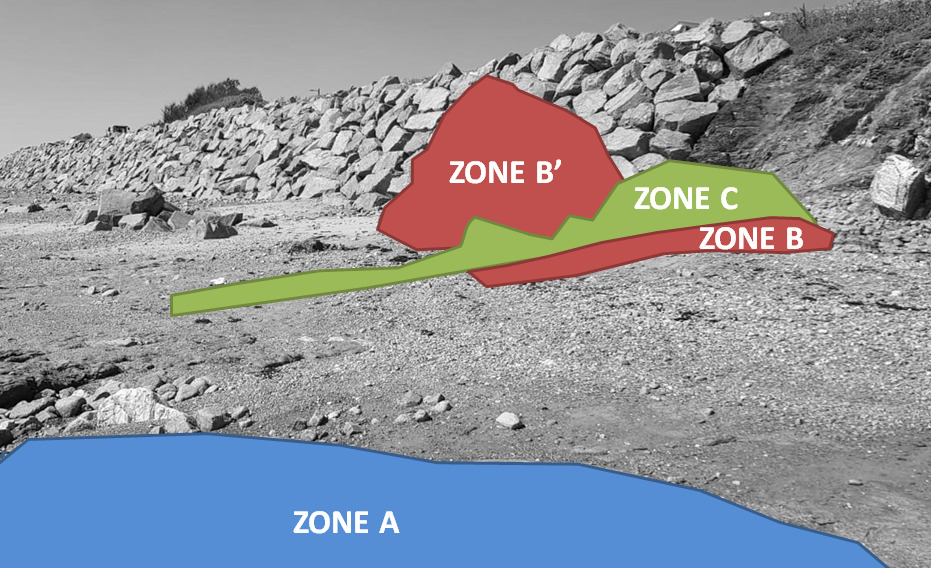
- Question 1 : Décrivez la zone bleue A et identifiez la roche. Est-elle d'origine ou remaniée ?
- Question 1: Describe the blue zone A and identify the rock. Is it original or modified?
- Question 2 : Décrivez la zone rouge B et identifiez la roche. Est-elle d'origine ou remaniée ? Selon vous, ou se situe l'endroit où débute la zone du décrochement?
- Question 2 : Describe the red zone B and identify the rock. Is it original or modified? Deduct from it the place where the drop zone begins.
- Question 3 : Que voyez-vous sous la zone verte C ? Quelle est sa largeur? Décrivez la formation et déduisez-en sa nature.
- Question 3 : What do you see under green zone C? How wide is it? Describe the formation and deduce its nature.
- Question 4 : Avec une boussole, évaluez la direction de la formation de la zone C. Est-elle cohérente avec l'histoire tectonique locale ?
- Question 4 : Using a compass, assess the direction of the Zone C formation. Is it consistent with local tectonic history?
- Question 5 : A l'aide du principe de datation, évaluez l'ordre d'apparition des formations A, B et C.
- Question 5 : Using the dating principle, assess the order of appearance of formations A, B and C.
Vous pouvez vous loguer sans attendre notre confirmation,
mais vous devez nous envoyer les réponses par mail en même temps via notre profil (
fafahakkai).
S'il y a des problèmes avec vos réponses nous vous en ferons part.
Les logs enregistrés sans réponses seront supprimés.Une photo de vous ou de votre GPS à un des WPs (mais sans prendre en photo le panneau ou les spots d'observation) serait la bienvenue, mais n'est pas obligatoire
You can log this cache without waiting for our confirmation, but you must send us the answers by e-mail at the same time via our profile (fafahakkai).
If there is a problem with your answers we will notify you. The logs recorded without answers will be deleted.
A picture of you or your GPS to a WPs (but not to photograph the sign or observation spots) would be welcome but is not mandatory.
Rappel concernant les « Earthcaches »: Il n'y a pas de conteneur à rechercher ni de logbook à renseigner. Il suffit de se rendre sur les lieux, de répondre aux questions ci-dessus et de nous renvoyer les réponses.
Reminder concerning "Earthcaches": there is neither a container to look for nor a logbook to sign. One need only go to the location, answer to the differents quiestions and send us the answers.