>
WELCOME TO 72 FAULTS AND FOLDS
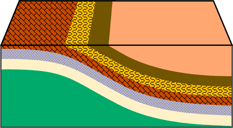
I should say Hwy 72 Faults and Folds. At this location, State Route 72 cuts through a very large formation of late Paleozoic Chert. Chert is a very hard sedimentary rock who's colors vary from opaque black to gray, white, yellow, brown, and red. It probably formed from the remains of ancient sea sponges or other ocean animals that have been fossilized. Silica has replaced the tissue forming the sedimentary rock. There’s a bunch of faults and folds here but I don’t think there’s 72 of them. The coords should take you to the incredible fold you see below

Now let’s learn a little about faults and folds so you’ll know how to claim this Earthcache.
Deformation of rock involves changes in the shape and/or volume of these substances. Changes in shape and volume occur when stress and strain causes rock to buckle and fracture or crumple into folds. A fold can be defined as a bend in rock that is the response to compressional forces. Folds are most visible in rocks that contain layering. For plastic deformation of rock to occur a number of conditions must be met, including:
(A) The rock material must have the ability to deform under pressure and heat.
(B) The higher the temperature of the rock the more plastic it becomes.
(C) Pressure must not exceed the internal strength of the rock. If it does, fracturing occurs.
(D) Deformation must be applied slowly.
There are several classifications of folds. For your convenience, I’ve listed them with pictures below.
The first and simplest is called a MONOCLINE. This fold involves a slight bend in otherwise parallel layers of rock.
Next is the ANTICLINE. This is a convex up fold in rock that resembles an arch like structure with the rock beds (or limbs) dipping way from the center of the structure.

Next is the SYNCLINE. This is a fold where the rock layers are warped downward. Both anticlines and synclines are the result of compressional stress.

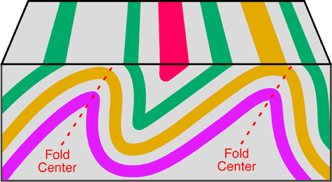
More complex fold types can develop in situations where lateral pressures become greater. The greater pressure results in anticlines and synclines that are inclined and asymmetrical. An example is below;
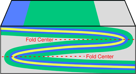
The last fold we’ll talk about is the RECUMBENT fold. This fold develops if the center of the fold moves from being once vertical to a horizontal position. Recumbent folds are commonly found in the core of mountain ranges and indicate that compression and/or shear forces were stronger in one direction. Extreme stress and pressure can sometimes cause the rocks to shear along a plane of weakness creating a fault. We call the combination of a fault and a fold in a rock an overthrust fault.
Now let’s learn about FAULTS.
Faults form in rocks when the stresses overcome the internal strength of the rock resulting in a fracture. A fault can be defined as the displacement of once connected blocks of rock along a fault plane. This can occur in any direction with the blocks moving away from each other. Faults occur from both tensional and compressional forces.
There are several different kinds of faults. These faults are named according to the type of stress that acts on the rock and by the nature of the movement of the rock blocks either side of the fault plane.
Below are animated examples of faults.
The first is a NORMAL FAULT. Normal faults occur when tensional forces act in opposite directions and cause one slab of the rock to be displaced up and the other slab down.

Next is a REVERSE FAULT. These develop when compressional forces exist. Compression causes one block to be pushed up and over the other block.

Now we have a GRABEN FAULT. These are produced when tensional stresses result in the subsidence of a block of rock. On a large scale these features are known as Rift Valleys

And finally we have the HORST FAULT. This is the development of two reverse faults causing a block of rock to be pushed up
All of this helpful information as well as much more can be found atvisit link.
Now that you are a pro at identifying folds and faults, let’s get to the qualifications for claiming this cache.
To claim this Earthcache, you need to:
(1) Take a picture of yourself with GPS at the fold I’m pointing to above.
(2) Using the photos above, what type of fold do you think this one is?
(3) Find another fault or fold on this cut (or the one on the other side of the road) and upload a picture of it explaining it as well.
(4) In your own words, explain how these faults and folds were formed.
This cache can't be done at night unless I can clearly see you in the picture. Please don't post your answers in your log.
Any "FOUND IT" log without your picture and without the correct answers emailed to me will be DELETED. Thanks and HAPPY CACHING!
| I have earned GSA's highest level: |
 |


(click to visit our website)