Menomonee River: Straight, Sinuous or Meandering? EarthCache
Menomonee River: Straight, Sinuous or Meandering?
-
Difficulty:
-

-
Terrain:
-

Size:  (not chosen)
Please note Use of geocaching.com services is subject to the terms and conditions
in our disclaimer.
This is an EarthCache. It has no physical container or log book. An EarthCache presents some lesson on how a place was formed, about why that place is important scientifically or what that site can tell us about our planet.
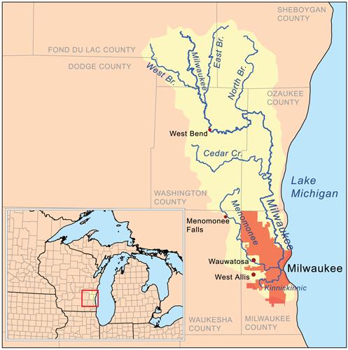
The Menomonee River is a tributary of the Milwaukee River. The Menomonee River watershed covers approximately 140 square miles of urban landscape. This includes portions of Washington, Ozaukee, Waukesha, and Milwaukee Counties.
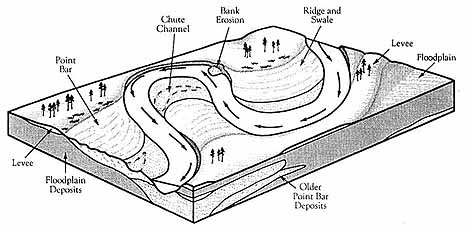
A meander in general is a bend in a sinuous watercourse. A meander is formed when the moving water in a river erodes the outer banks and widens its valley. A stream of any volume may assume a meandering course, alternatively eroding sediments from the outside of a bend and depositing them on the inside. The result is a snaking pattern as the stream meanders back and forth across its down-valley axis.
Most meanders occur in the region of a river channel with shallow gradients, a well-developed floodplain, and cohesive floodplain material. Erosion is greater on the outside of the bend where velocity is greatest. Deposition of sediment occurs on the inner edge because the river, moving slowly, cannot carry its sediment load, creating a slip-off slope called a point bar. The faster moving current on the outside bend has more erosive ability and the meander tends to grow in the direction of the outside bend, forming a small cliff called a cut bank. This can be seen in areas where willows grow on the banks of rivers; on the inside of meanders, willows are often far from the bank, whilst on the outside of the bend, the roots of the willows are often exposed and undercut, eventually leading the trees to fall into the river. This demonstrates the river's movement. Slumping usually occurs on the concave sides of the banks resulting in mass movements such as slides.
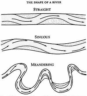
The meander ratio or sinuosity index is a means of quantifying how much a river or stream meanders (how much its course deviates from the shortest possible path). It is calculated as the length of the stream divided by the length of the valley. A perfectly straight river would have a meander ratio of 1 (it would be the same length as its valley), while the higher this ratio is above 1, the more the river meanders.
The sinuosity index has been used to separate single channel rivers into three general classes: straight (SI < 1.05), sinuous (SI 1.05-1.5), and meandering (SI > 1.5)
For this EarthCache, you are going to estimate the sinuosity of a portion of the Menomonee River, starting near the posted coordinates at Burleigh Street. While the river is not large enough for you to sail a boat down, the Menomonee River Parkway closely follows the winding path of the river. At your discretion, you may hike, bike or drive in your car. Before you start, just remember to zero out your trip odometer. Then simply follow the Parkway southbound and enjoy the view. I suggest taking it at least to Swan Boulevard, but you may continue as far as Harmonee Avenue in downtown Wauwatosa.
Once you have arrived at the end of your trip, take the total mileage traveled from the trip odometer and divide that by the distance you are from the starting coordinates. For example, if you traveled 3.00 miles and you are 1.50 mile from the starting point, your sinuosity index would be 3.00 divided by 1.50 equals 2.0 which, according to the definitions above, would be "meandering".
To log a "Found It" for this Earth Cache, you must do the following:
1) Email me (do NOT post in your log):
- The distance you traveled.
- Your distance from the starting coordinates.
- Your calculated sinuosity index.
- How you would classify this portion of the river.
- Finally, using the geocaching maps, take a look at how the river actually flows compared to the windings of the Parkway road. How do you think the actual sinuosity index would compare to your estimate?
2) Voluntary (no longer a requirement): Do include in your online log:
- A photograph of you, your team or your GPS in hand with one of the big brown wooden County Park signs in the background clearly showing that you are in the correct Parkway.
- Another photograph of any scenic view along the river.
Additional Hints
(No hints available.)