10 A Walk in the Garden-Kirikee/Carriglineen Mystery Cache
10 A Walk in the Garden-Kirikee/Carriglineen
-
Difficulty:
-

-
Terrain:
-
Size:  (small)
Please note Use of geocaching.com services is subject to the terms and conditions
in our disclaimer.

Spring has brought me to seek you out in these hills.
The sound of
your axe chopping wood breaks the
stillness.
I cross rivulets yet covered with snow
and ice.
The sun's rays through the Stone Gate Cliffs reaches this
spot.
You care nothing for the gold and silver in these azure mountains;
You go with deer and learn from them how
they avert harm.
We tramp around and soon lose ourselves,
Carefree as a pair of empty boats adrift.
Every turn of the landscape shall be absorbed into my bosom.
Every bird or flower shall be my friend.
(Tu Fu)
This is a lovely gentle walk in the Garden County of 7.5K with
about 450m ascent. In all it should take less than 2 hours. The
above coordinates are just for guidance. You will need to solve the
puzzle here to find the coordinates for Stage 1 where you will then
receive the coords for the final cache. You may need to see this
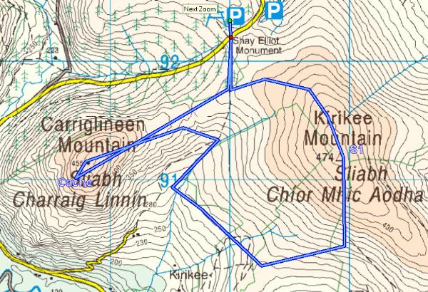
cache page on a PC or similar. The best place to start is the Shay
Elliot Forest Park at N 52° 58.136 W 006° 19.160. Walk to a
crossroads (forest park roads) at the given coordinates and go left
for Stage 1. Follow the track up staying on the moorland side of
the fence. Stage 1 is near the trig point of Kirikee and you may
wish to step into the private field but it is not absolutely
necessary to trespass on any private property (but it is a lot
easier, and an old stile exists for the purpose).
To make a nice circuit walk head for N52 57.354 W006 18.781 where
you can turn right on a forest track toward the final cache. There
are a number of ways from there but an easy walk is to a gate at
N52 57.687 W006 19.213. If you stay on the forest side of the fence
then as far as N52 57.680 W006 19.387 you can elect to go for the
cache or head up to a stile (N52 57.817 W006 19.527) which will
take you on a bog path (a lot easier) up to the cache. It is a
straightforward walk back over that stile and continue straight
ahead to the starting point then back to the car. The view from the
final cache itself is pretty spectacular so do take a
picture!
Please be clearly aware that
anyone attempting this cache does so entirely at their own risk and
that the cache owner has no liability of any sort and for any
reason, accident or mishap. As this is a mountain hike please be
sure to bring warm and waterproof clothes and all the mapping,
compass and GPS items that you can. Good hiking boots and gaiters
would be useful in most weathers
Please be aware that cars parked
in areas close to walking trails are vulnerable and they can be
vandalised or stolen. Unfortunately this is an ongoing problem
which is extremely difficult to solve. so there is a risk involved.
I have heard recently that many hiker groups are parking at the
nearest population centres and getting taxis to and from the start
points at very little expense.
Please observe the country code to the best of your ability. Local
landowners often generously allow access to upland areas across or
through parts of their private property. Please, please be
conscious of this and return the courtesy by keeping all gates
closed, immediately and not on your way back!. Please use the gates
where appropriate but if you have to climb over them then use the
hinged side ONLY.
Please do not cause any damage of any sort to fences or barriers
along the way.
Additional Hints
(Decrypt)
Nabgure bar!