Donaudurchbruch Beuron EarthCache
-
Difficulty:
-

-
Terrain:
-
Size:  (other)
Please note Use of geocaching.com services is subject to the terms and conditions
in our disclaimer.
Der Donaudurchbruch Beuron
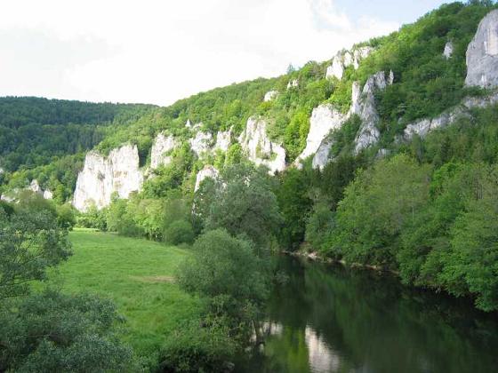
Entstehung des Oberen Donautals
Das heute eher kümmerlich wirkende Donauflüsschen hat wohl kaum diese imposante Naturkulisse herauspräpariert. Vielmehr war es die ehemalige Urdonau, die vor 3-5 Millionen Jahren (im Pliozän des ausgehenden Tertiärs) ein gewaltiger Strom war, der auch als Aare-Donau bekannt ist und große Gebiete der Nordschweiz und der Feldbergregion entwässert hat. Später hat der Urrhein durch rückschreitende Erosion des aus dem Gebiet des heutigen Oberrheintals die Donau angezapft und ihr den Quellfluss Aare geraubt.
Das Flussbett hat sich bis zu 200 m in den Jurafels eingegraben. Heute liegt die geringe Wasserführung der Donau auch in den ausgeprägten Karsterscheinungen. Die zerklüfteten und porösen Kalksteine lassen das Wasser in unterirdischen Spalten versinken. Ganz in der Nähe liegen auch die weltberühmten Donau-Versickerungsstellen bei Immendingen und Fridingen. Hier verliert die Donau an etwa 200 Tagen im Jahr ihr gesamtes Wasser, das dann nach einer unterirdischen Laufstrecke im ??? km entfernten Aachtopf wieder austritt und über den Bodensee dem Rhein zufließt.
Die riesigen Massenkalkfelsen der Schwäbischen Alb entstanden während der Zeit des Oberen Weißjura (Malm). Der Zeitraum, als dieses warme und flache Meer Süddeutschland überdeckte, liegt etwa 140 bis 160 Millionen Jahre zurück. Die Schichtenfolge aus Kalksteinen und Kalkmergelsteinen ist 400 bis 600 mächtig. Das warme und flache Meer, das dem heutigen Arabischen Golf oder dem Great Barrier Reef Australiens vergleichbar ist, bot zahlreichen Meerestieren Lebensraum wie Muscheln und Kopffüßlern (Ammoniten), Schnecken, Seeigeln, Seelilien und Schwämmen. In dem feinen Kalkschlamm am Meeresgrund konnten sich die Schalen und Skelette der Tiere gut erhalten.
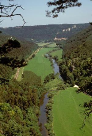
Die hoch aufragenden und durch die Erosion herauspräparierten Felsen sind die zu Stein gewordenen Schwammriffe, die über den Meeresgrund hinauswuchsen und heute aufgrund ihrer größeren Härte wiederum herausragen. Zahlreiche Fossilien sind in den kalkigen Gesteinen erhalten und bieten den Fossiliensammlern immer wieder überraschende Funde. Das Obere Donautal bildet sowohl in Längs- wie auch in Querrichtung ein natürliches Hindernis. Daraus resultiert eine relativ gering Siedlungsdichte.
Der Donaudurchbruch bei Beuron wurde in die Liste der bedeutendsten Geotope Deutschlands aufgenommen. Bei den bedeutendsten Geotopen handelt es sich, je nachdem ob Einzel-Geotop, Geotop-Ensemble oder Geotop-Landschaft, um herausragende geowissenschaftliche Objekte in Deutschland. Die bedeutendsten Geotope müssen langfristig erhaltbar sein. Sie sollten öffentlichen Informationsmöglichkeiten zugeordnet sein wie einem Museum, Lehrpfad oder einem ausgewiesenen Besichtigungsobjekt. Sie können auch Bestandteile eines Geoparks sein.
Logbedinung
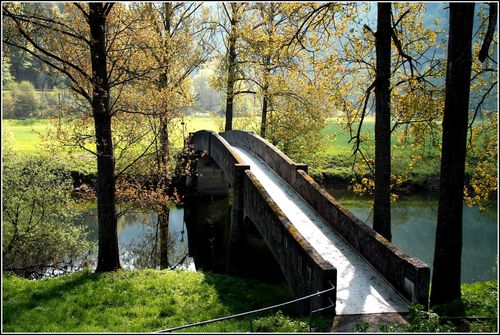
Macht ein Bild von euch oder eurem GPS und der Brücke und der Donau im Hintergrund und beantwortet mir folgende Frage. Wie lang ist die unterirdische Laufstrecke? 12, 50 oder 300 km lang?
Schickt mir eine Mail mit der richtigen Lösung, loggen könnt Ihr sofort. Auf Bilder im OnlineLog freue ich mich sehr.


Englisch Description
Der Donaudurchbruch Beuron
origin of the Oberes Donautal
The Donau rivulet working rather miserably today hardly has this imposing physical scenery herauspräpariert. Rather it was the former old danube which was before 3-5 million years (in the Pliozän of the outgoing Tertiärs) an immense stream which is also known as the eagle's Danube and has drained big areas of the Nordschweiz and the field mountain region. Later the old rhine by back-walking erosion from the area of the today's Upper Rhine valley has tapped the Donau and has robbed her of the source river eagles.
The riverbed has dug itself in up to 200 m in the law rock. Today the low water guidance of the Danube also lies in the distinctive two-pronged mattock phenomena. The cleft and porous limestones let the water sink into subterranean columns. Very near the world-famous Donau-Versickerungsstellen also lie with Immendingen and Fridingen. Here the Danube on about 200 days in the year loses her whole water, then after a subterranean run distance in ??? km removed Aach pot again resigns and over Lake of Constance runs towards the Rhine.
The gigantic mass lime rocks the Swabian nightmare originated during the time of the upper white law (Malm). The period when this warm and level sea South Germany covered dates back from about 140 to 160 million years. The layer result from limestones and lime marl stones is mighty from 400 to 600. The warm and level sea which is comparable to the today's Arabian gulf or the Great Barrier Reef of Australia offered to numerous sea animals living space like mussels and Kopffüßlern (ammonite), snails, sea urchins, sea lilies and sponges. In the fine lime mud in the seabed the bowls and skeletons of the animals were able to do themselves well-preserved.
The highly rising and by the erosion herauspräparierten rocks are the fungous reefs become to stone which outgrew the seabed and stand out today on account of her bigger hardness again. Numerous fossils are received in the calcareous rocks and offer astonishing findings to the fossil collectors over and over again. The upper Danube valley forms in longitudinal direction as well as in transverse direction a natural obstacle. From it there results a relatively slightly settlement density.
The Danube breakthrough with Beuron was taken up in the list the most important geotop of Germany. With the most important Geotopen it concerns, depending on whether singles-geotop scenery, geotop ensemble scenery or geotop scenery, around prominent geoscientific objects in Germany. The most important geotop must be receiveable in the long term. They should be assigned to public possibilities of information like a museum, teaching path or a stated inspection object. They can also be components of a geopark.
Logpermission
Take A picture of you and your GPS and the Donau in front of the brigde, and answers this question. How long is the subterranean run distance? 12, 50 or 300 km long?
The answer sends me by mail and you get the log release, still your picture hangs on your log please.
Quelle: Ministerium für Umwelt, Klima und Energiewirtschaft Baden Württemberg
Additional Hints
(No hints available.)